The Most Revolutionary Stroll in America: Independence National Historic Park

Imagine a place where the ideas that formed a nation were not only spoken — they were voted on, debated, perfected, and signed. That’s Independence National Historical Park in Philadelphia, Pennsylvania — often called “America’s most historic square mile.”

Photo by S. Resendez

The park wasn’t always a unified place you could stroll through. It began as a scattering of historic sites tied to the birth of the United States–Independence Hall (then the Pennsylvania State House), Carpenters’ Hall, the Liberty Bell, and other landmarks. In 1948, this cluster of landmarks was officially authorized as a historic park. The NationalPark Service began administration in 1950, with the park formally established in 1956. Over decades it expanded to protect more of Old City and Society Hill’s historic streets — now about 55 acres of vital American history. This park is also a UNESCO World Heritage Site because it isn’t just local history — it’s world history.

What makes this park unique is not just the buildings, but the ideas forged inside them — the concepts of liberty, democracy, and constitutional governance that influenced nations around the globe.

“Must-see” areas of the park to add to your itinerary:

Independence Visitor Center–Start here. It’s the gateway — with free maps, park info, and orientation films that set the stage.

 Independence Hall — Where history was literally made: The Declaration of Independence was debated here, in the Assembly Room, in 1776, and the Constitution later in 1787. The same space saw debates on the Articles of Confederation, and the very chair where George Washington sat during the Constitutional Convention — the “Rising Sun” chair — still stands. This building testifies to how 13 colonies decided to become a single nation — a dramatic leap in human governance that shaped the modern world. Note: Tickets for guided tours are free but required during peak months, so plan ahead.

Photo by S. Resendez

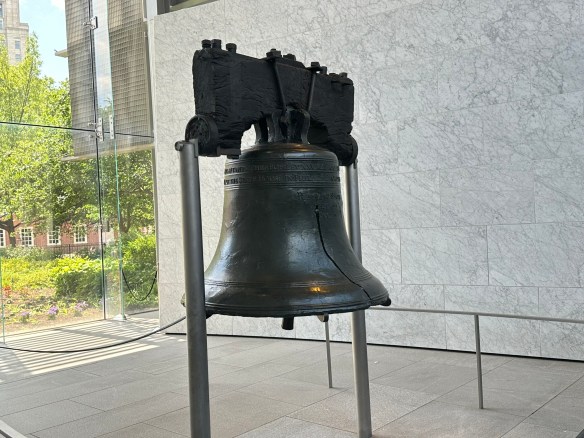
Liberty Bell Center — Icon of Freedom: Across from Independence Hall stands the Liberty Bell, a globally recognized symbol of liberty and justice. Cast in 1752, its famous crack came early and remains its defining feature.

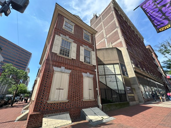
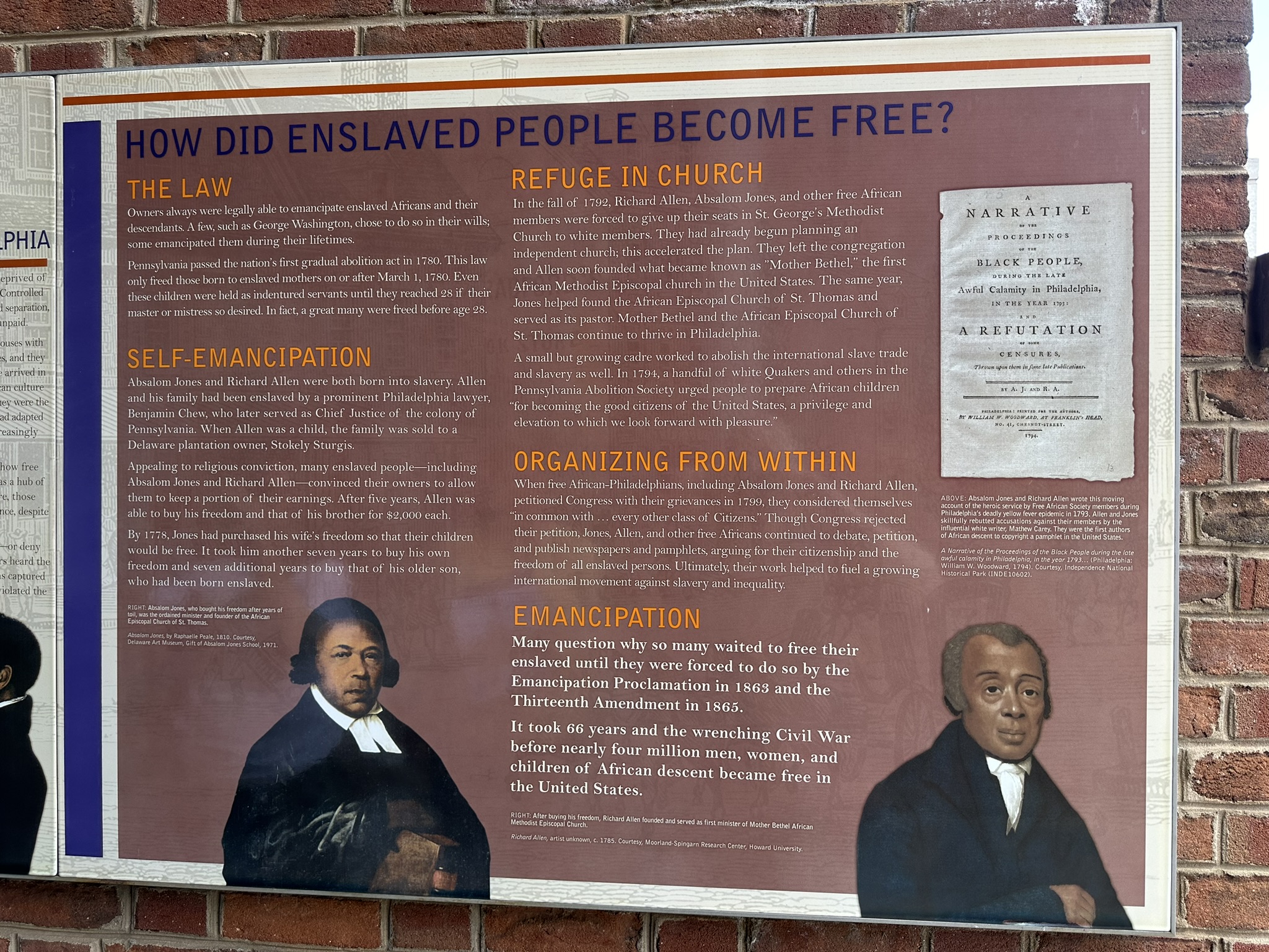
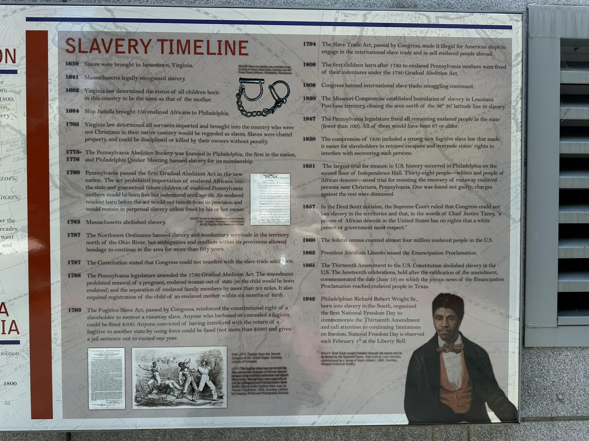
Presidents’ House Site: Near the Bell you’ll see the remains of the home where George Washington and John Adams lived while Philadelphia was the national capital (1790–1800). Recent exhibits explored the lives of the enslaved people who lived and worked there, underscoring the era’s contradictions between freedom and slavery. This is history that cannot be changed regardless of how some people would prefer to do so.

Franklin Court & Benjamin Franklin Museum: Honor Benjamin Franklin — inventor, diplomat, founding father. His house site and museum are nearby, with exhibits on his life and contributions.

The park today spans over 50 acres and ~20 blocks, from historic squares and buildings to restored streetscapes. The Independence Visitor and the Liberty Bell Center are open daily 9:00 am–5:00 pm. The President’s House Site is open daily 7:00 am–10:00 pm. Different halls and different buildings may have different hours or may be closed so check ahead before your visit.

Admission to most park sites is free. Entrance to Independence Hall is by both guided and self-guided tours. Check here for current hours. Guided tours require tickets that can be reserved through Recreation.gov. There is a $1 per ticket handling fee. Interagency passes do not apply to these fees. The Benjamin Franklin Museum charges an interpretive fee and the National Constitution Center, a partner of the park, charges an admission fee. Other museums and halls may have different fees and schedules so make sure you check before your visit.

MILE MARKER: Did you know that The Declaration wasn’t signed all at once? Despite the iconic painting, the Declaration of Independence wasn’t signed in one dramatic moment. Most delegates signed weeks later, and some weren’t even in town on July 4. So Independence Day is more of a publication date than a signature party.

HIKE IT!: No hiking trails here but you will walk! This park consists of 55 acres of buildings, halls, exhibits, and squares. You’ll definitely get some steps in!

Through Fields of Fire and Footpaths: Gettysburg National Military Park

Photo by S. Resendez

Gettysburg is where the nation turned and where a battlefield became sacred ground. Gettysburg National Military Park preserves the site of the Battle of Gettysburg (July 1–3, 1863), the bloodiest battle ever fought on American soil and a turning point in the Civil War. More than 51,000 soldiers were killed, wounded, captured, or declared missing in just three days. The battle ensued across rolling farmland, rocky hills, orchards, and small town streets. The battle erupted almost accidentally when Confederate troops encountered Union cavalry near the town of Gettysburg, Pennsylvania. What began as a scouting expedition quickly escalated into a massive three-day engagement involving over 165,000 soldiers.

After the battle, local citizens worked to recover bodies and care for the wounded. A Soldiers’ National Cemetery was created for Union dead. It was here that President Abraham Lincoln delivered the Gettysburg Address in November 1863 — redefining the war as a struggle not just for union, but for equality and democracy.

Photo by S. Resendez

The Battle of Gettysburg is important for several reasons:

  • It Stopped the Confederate Invasion of the North–General Robert E. Lee hoped to win a major victory on Northern soil, potentially forcing peace negotiations. Instead, his army suffered devastating losses and had to retreat back to Virginia.
  • It Shifted Momentum Toward the Union–After Gettysburg, the Confederacy never again launched a full-scale invasion of the North. The Union gained confidence and strategic advantage.
  • It Redefined the Meaning of the War–Lincoln’s Gettysburg Address framed the war as a fight for equality and democratic ideals — not simply preservation of the Union.
  • It Became a Symbol of Sacrifice and Unity–Gettysburg represents the cost of division and the power of reconciliation — something visitors still feel walking the fields today.
Stone wall on Cemetery Ridge
Photo courtesy of NPS

Today, the park protects over 6,000 acres, with more than 1,300 monuments, markers, and memorials, making it one of the most monument-dense historic landscapes in the world. Visitors can hike the same ridgelines and walk the same fields where Union and Confederate soldiers fought, often within feet of original stone walls, farm buildings, and cannon placements. It serves as a perfect junction for hikers and history lovers alike, it’s a rare place where the outdoors and American identity intersect.

Park hours for Gettysburg National Military Park are from sunrise to sunset. The battlefield and roads are open thirty minutes before sunrise to thirty minutes after sunset. Visitors can plan their visit and obtain a listing of sunrise and sunset times by day in Gettysburg, PA here. Visitor Center hours change by season so make sure you check the website for more detailed information.

MILE MARKER: Did you know Gettysburg almost became an amusement park?
In the late 1800s and early 1900s, parts of the battlefield were treated more like a tourist playground than sacred ground. There were trolley lines, picnic groves, dance pavilions, and even proposals for roller coasters and a Ferris wheel near key battle sites. Visitors could ride out to the battlefield for leisure outings, not reflection. It wasn’t until preservation groups and the federal government stepped in that large sections of the land were protected and restored to their historic appearance.

HIKE IT!: There are no hiking trails in the park but that doesn’t mean you won’t be getting your steps in. Places in the park like Gettysburg National Cemetery or taking a Gettysburg Battle Walk will make sure you get your exercise. Just check the weather and plan accordingly.

Hiking the Edge of Alaska: Kenai Fjords National Park

Photo by S. Resendez

Mountains, ice, ocean, and glaciers…have I left anything out?

Kenai Fjord National Park is located in south-central Alaska on the southeast coast of the Kenai Peninsula, primarily accessed from the town of Seward. It is situated about 130 miles (2.5-hour drive) south of Anchorage and is known as the place “where mountains, ice, and ocean meet,” featuring the massive Harding Icefield and coastal glaciers. It is one of the few Alaska national parks accessible by road and ies south of the Kenai National Wildlife Refuge and north of the Gulf of Alaska.

This part of Alaska has long been populated by the Sugpiaq (also known as Alutiiq) whom are often referred to as the “people of the seal.” They have lived in, and around, the Kenai Fjord area for over 7,800 years. They learned to rely on the ocean for food, clothing, and materials, using seal gut for waterproof parkas and harvesting such resources as mussels, clams, algae, and crustaceans. While these cultures and others subsisted on harvesting, gathering, preparing, and sharing wild foods, subsistence hunting is no longer allowed within the borders of the park because it is a national park and not a national preserve. However, subsistence practices are still allowed on corporation-owned lands within the park and its adjacent waters. The Sugpiaq/Alutiiq people still maintain a close relationship with the land and remain an integral part of the area.

There are three main areas of the park that provide opportunities to see the park through varied lenses:

  • Exit Glacier: The Exit Glacier area is the only part of the park accessible by road. This area also offers an opportunity to take a short, accessible, one mile loop hike that takes you to a panoramic vista of Exit Glacier spilling down from the Harding Icefield.
  • The Coastal Fjords:  Several local companies offer opportunities to see the park’s coastline, tidewater glaciers, and marine mammals up close. If you’d prefer to do it yourself, kayaking is also an option.
  • The Harding Icefield: This is the star of the show. During the last ice age, the immense pressure of glaciers from the icefield scoured the coastal mountains, carving deep, steep-walled valleys.
    As the climate warmed and the glaciers retreated, the ocean filled these U-shaped valleys, creating the characteristic steep-walled fjords. The combination of retreating ice and rising sea levels transformed the landscape, leaving behind a coastline where mountains drop directly into the ocean, sometimes descending 600 to 1,000 feet below sea level. If you’re the strenuous type, you can take a full day to hike the strenuous 8 mile round trip trail. Mountaineering here is also an option if you’re a mountaineer with several outfitters and guides to assist in the planning. Probably the best way to view the Harding Icefield would be from the sky, with flightseeing overflights. More information for those flights can be found at the Seward Chamber of Commerce.

Kenai Fjords National Park is open year round. The primary months to visit are June, July, and August. There are reduced services in the area during the months of May and September. The Visitor Centers are open from Memorial Day weekend (last weekend of May) through Labor Day (first Monday of September) unless otherwise noted.

Being at Kenai Fjord National Park is about moving through a landscape shaped by ice, animals, and generations of people who learned to live with both. Whether you go for the trails, the scenery, the wildlife, or the cultural echoes of this rugged coastline, Kenai Fjords teaches us to move slowly and enjoy creation.

MILE MARKER: Would you believe that the Harding Icefield contains remnants of the vast Pleistoscene ice sheets that once covered much of Alaska?! The Pleistocene Ice Age occurred from approximately 2.58 million to 11,700 years ago.

HIKE IT!: There are only two maintained trails in Kenai Fjords National Park. They are the connected Exit Glacier Trails and Harding Icefield Trail. The trailhead for both starts just beyond the parking lot at the end of Exit Glacier Road. Make sure you check out the local conditions as you plan your trip to the park.

Leaves, Limestone, and Guadalupe River State Park

Photo by S. Resendez

It’s a Hike & Feast!! That’s right, we’re headed for a hike at the Guadalupe River State Park, about 30 minutes northwest of San Antonio off Highway 46, west of 281 North.

This was the very first state park I ever visited when I first started camping. At the time of this first visit, I was a poor, case manager. Bachelor’s degree in hand, first professional job, still making peanuts. My housemate and I were looking for ways to have some fun that didn’t cost a lot of money. We decided to try our hand at camping so we splurged on a tent and somehow, I don’t really remember how, we found this park, made a reservation and spent a lovely weekend sleeping on the hard ground, grilling meats, hanging out at the river, and just generally, enjoying nature.

This isn’t my favorite state park but it does hold a special place in my heart because it was where I discovered camping. I’d been to Rocky Mountain National Park with my college roommate and her family before this camping trip, but they had a pop-up trailer and all I had to do was sit back and let my friend’s dad be in charge. The trip to Guadalupe River State Park was my first time setting up my own campsite, starting a campfire, and all the other camping experiences that came with it, including the midnight trips to the bathroom. But it was all good because that little bit of camping led to backpacking which led to hiking and here we are today! It’s a full circle for me.

Photo by M. Gonzalez

Guadalupe River State Park, as the name implies, sits smack dab on the Guadalupe River. The river here runs quiet and serene. The gentle flow makes it perfect for kids to get in and float down aways on a tube or raft, climb out, and do it all over again. The day use area is right on the river and you’d better believe it gets crowded in the summer. If you’re looking to camp here in the summer (as well as spring and fall if it’s warm enough), it’s going to be busy. It’s not the getaway you might be looking for if you’re looking for silence or quiet nature. But, if you’re looking for a place to hike some quiet, easy, and beautiful trails, you’ve come to the right place. Especially if you’re here in the fall and winter. Spring is also a magical time when the wildflowers are in bloom.

Guadalupe River State Park is part of the area we’ve discussed in some of our other blogs and in our podcasts. Like Pedernales River State Park and our first Hike & Feast at Crownridge Canyon Natural Area, Guadalupe River State Park is an area comprised of limestone canyons that used to be a seabed. Dramatic canyon walls and rocky outcrops were formed when this region was covered by a shallow sea millions of years ago. If you look closely at the limestone layers, sometimes you can find fossiliferous limestone, better defined as fossils of seashells and organisms fossilized right into the limestone. Bonus if you’re a birder! This park sits at the crossroads of Hill Country and riparian ecosystems, making it an important stopover for migratory birds. Fall hikers often don’t realize they’re walking through habitat used by golden-cheeked warblers, painted buntings, and migrating raptors. Susan and I hiked the Painted Bunting Trail, named after the beautiful painted bunting bird (which we did not see while we were hiking, damn it).

This park has plenty of trails ranging from easy to challenging. Trail lengths range from 0.3 miles all the way to 3.1 miles. There are also river crossings if you’re looking to roll up your pants and get your feet wet. Terrain is varied and there are some trails that are short but steep, so choose wisely.

This is a great, little getaway right down the road from San Antonio. And there are plenty of places to feast after you finish up your hike. We made our way a few miles up the road to Spring Branch, Texas where we feasted on chicken fried steak at Antler Cafe. Delicious!

FEAST! Chicken Fried Steak at Antler Cafe in Spring Branch, Texas

MILE MARKER: Guadalupe River State Park protects one of the cleanest stretches of the Guadalupe River. Unlike the more heavily trafficked downstream sections (like New Braunfels), this stretch of the river is spring-fed and less developed, which helps keep the water unusually clear and ecologically healthy. It’s a quiet reason why the park feels so calm compared to other Guadalupe access points.

HIKE IT!: Make sure you check out the park’s website hiking page for links to their trail map but notice that there’s a secret hike on there! That’s right, there’s a secret hike at the connected Honey Creek State Natural Area. Access to this special area is allowed only by tour which is a 2 mile, ranger led tour, that only happens once a week. Click on the link to get to the Honey Creek website and sign up for that special hike there.

Land of Standing Stones: Discovering the Magic of Chiricahua National Monument

Photo by S. Resendez

We’re here again. We’re in a place settled long, long ago by people who migrated to North America thousands of years ago across the Bering land bridge or by sea. Their ancestral homeland was believed to be around modern-day Siberia/Mongolia, eventually settling across Alaska, northern Canada, and the American Southwest. Their migrations occurred in waves, with later groups moving south and east from an initial Alaskan settlement, adapting to diverse environments from subarctic forests to desert regions. These people are the Athabaskan people. We mentioned them in our episode about Canyon de Chelly.

As these people made their way down to what we now refer to as the Southwestern United States (between 1400 and 1500), the Chiricahua eventually settled in what is now southeastern Arizona, southwestern New Mexico, and northern Mexico in the Sonoran and Chihuahuan Deserts. The Chiricahua people are named after the Chiricahua Mountains in southeast Arizona. The Apache Indians were only one of the bands of Chiricahua Indians that evolved into different clans.

As it was, and still seems to be, the way of the United States to take what belongs to someone else (for more current information, see “Greenland”) the Apache Wars of 1861 culminated, after 24 years, in the creation of a reservation for the Chiricahua people that allowed them to live in relative peace until the death of Cochise, when the reservation was abolished and the people were forced to move to another reservation.

After the Chiricahua people were relocated, settlers and ranchers moved into the area and in the 1930’s, the Civilian Conservation Corp (CCC) came into the region and were responsible for the construction of many of the roads, parking areas, and trails. Many of the trails were built for recreation but some of them were designed specifically to allow access for firefighters.The Sugarloaf Trail, for example, has the dual purpose of providing fire lookout access as well as recreational opportunities. The Natural Bridge Trail was constructed for the sole purpose of firefighter access into Picket Park.

Photo by S. Resendez

Bonita Canyon Highway offers a beautiful 8 mile drive to Massai Point, the culmination of a road that was constructed by the US Forest Service in 1932. The road is a narrow mountain road with low hanging trees and small parking areas. If you’re hauling a trailer, your trailer must be disconnected to drive up through Bonita Canyon. Chiricahua National Monument is a “Dark Sky” park, so be prepared for some intense stargazing!

Chiricahua National Monument is located at 13063 E Bonita Canyon Rd, Willcox, AZ. The park is open 24 hours a day. Trails stay open for sunrise, sunset, and night sky viewing. Be aware of wildlife and use extreme caution. There is no entrance fee or pass required to enter. The visitor center, on the right 3.5 miles after the entrance, is open from 8:30 am to 4:30 pm. It has an information desk, museum, park film, and gift shop. It provides free maps, junior ranger booklets, and information.

Photo by S. Resendez

MILE MARKER: Chiricahua National Monument was formed by a single massive volcanic eruption about 27 million years ago. The Turkey Creek volcano released such an enormous ash cloud that the material hardened into rock, creating the towering hoodoos and balanced stones we see today. When you hike here, you’re walking through what was once a volcanic ash blanket—now sculpted into a stone forest by time and erosion.

HIKE IT!: Once again, the National Park’s website offers a great hiking page which breaks the hikes down into easy, moderate, and strenuous hikes. Five easy hikes about a mile or less will take you to some of the most scenic areas in the park! Don’t forget, though, there is elevation in this park so acclimate to the altitude by doing a short hike first!


Welcome to 2026!

We’ve got lots of good stuff in store for you in 2026!

More hiking! New trips! New interviews! If there is anything else you might like for us to review or any place you’d like for us to check out this year, leave a comment down below and we’ll do our best to get there.

If you’ve been enjoying our content, do us a favor and consider buying some merchandise from our Zazzle Store or dropping a little coin to buy us a coffee. We would really appreciate it.

Happy hiking. Now get out there and hike your own hike!

When East Met West: A Traveler’s Guide to Golden Spike National Historic Park

Photo by S. Resendez

America was moving west and it wasn’t an easy trek. As settlers began making their way into and across the United States, there was a push to move westward in the 1800’s. Gold had been discovered, Spaniards were making inroads and discovering land and an abundance of natural resources. Places like Fort Davis were providing a safe respite from the wild west but it was taking time for get from one end of the country to the other. Wagon routes and months-long sea voyages were slowing progress. Many leaders—businessmen, politicians, and military planners—began calling for a faster, safer way to connect the nation, a nation dreaming of speed and connection.

But the idea stalled for years because Congress couldn’t agree on where the route should run. Northern states pushed for a northern path; Southern states demanded a southern one. The political deadlock broke only after the Civil War began, when Southern representatives (who preferred a southern route) withdrew from Congress. Suddenly, the northern-backed plan had a clear path forward.

In 1862, President Abraham Lincoln signed the Pacific Railway Act, officially launching the transcontinental railroad. The government supported it with land grants and loans, while two companies—the Union Pacific (building west from Omaha) and the Central Pacific (building east from Sacramento)—took on the construction. Their lines met in 1869 at Promontory Summit, Utah, forever transforming travel, trade, and the American West.

 On May 10, 1869, officials from the Central Pacific Railroad and the Union Pacific Railroad met at PromontorySummit, in Box Elder County, Utah, to drive the final, ceremonial spikes, linking the eastern and western United States by rail. In 1965, the site of the last spike on the transcontinental railroad was designated a National Historic Site. In March of 2019, the park’s designation was changed from a historic site to a historic park, just in time to for the commemoration on May 10, 2019, as America celebrated the 150th anniversary of the completion of the First Transcontinental Railroad and recognizing the historic site as the Golden Spike National Historical Park.

Photo by S. Resendez

While connecting the railways was indeed a giant leap forward for the United States, it should be noted that these strides were made on the backs of several groups of people. Native Americans were already settled in the west and the construction of the railroad caused the people from 15 tribal nations to watch their homes and livelihood be destroyed with the advancement of the railroad. Irish immigrants, who came seeking work during potato famine in the mid-1800’s, were instrumental in helping build the railroad despite religious discrimination and.a language barrier. And Chinese immigrants, who were reluctantly hired after a critical shortage of labor was created due to gold strikes, were responsible for a great majority of the hardest labor that went into building the transcontinental railway. Chinese workers were often given tasked with working in the most dangerous conditions. Tunnels in the Sierra Nevada Mountains that had to be bored into solid granite for the railroad, rockslides, explosions, exposure, avalanches, and violent clashes claimed the lives of many of the Chinese workers. It is estimated that over one thousand Chinese laborers died building the CPRR. At the 1869 Golden Spike ceremony, not a single Chinese laborer was invited or mentioned, despite their indispensable role.

Central Pacific Railroad Jupiter
Photo courtesy NPS

Today, Golden Spike National Historical Park offers a variety of things to do during your visit. Commemorative events, seasonal events, nature, and hiking are all available at this park. There are approximately 55,000 visitors a year and the visitor’s center is open seasonally, at various hours. Please check the website for specific information before your visit. The physical address is 6200 North 22300 West, Promontory, Utah. It is approximately 30 miles west of Brigham City. The park is 2,735 acres of land surrounding a 15 mile stretch of the original Transcontinental Railroad. There is only one paved road coming in to the visitor’s center.

MILE MARKER: Did you know that the famous golden spike wasn’t hammered into place at all—it was gently tapped, lifted back out, and sent home, while the real work of joining the rails happened quietly behind the scenes.

HIKE IT!: There is a 1.5 mile trail called the Big Fill Loop Trail. It provides a beautiful view of the Promontory Mountains, the Great Salt Lake, and the Wasatch Front. Visitors can walk along the original grades of the Central Pacific and Union Pacific railroads and still see drill marks from the tools used to create the tracks.

Wander the Petrified Wild at Petrified Forest National Park

Photo by S. Resendez

Imagine yourself in some open grasslands…the weather is humid and rainy. You can see that there’s a lush, beautiful forest nearby and in the river, there are large, expansive, trees growing in and around the river bottoms. The land is verdant and green. You’re actually standing in a flood plain. There are animals like wooly mammoth and giant bison roaming the area. This is the supercontinent Pangaea during the Late Triassic Epoch, over 225 million years ago. What we now recognize as the southwestern part of the United States.

Photo by S. Resendez

Over millions of years, as the continents moved, the land tilted and uplifted, and the climate changed significantly, transforming the environment from a tropical basin to an arid plateau. The trees in that forest eventually fell and became buried in the biorich sediment where mineral-rich water replaced the tree’s organic structure with minerals, and turned them into petrified logs. The gradual uplifting of the land (starting about 60 million years ago) created stress that caused the brittle, crystal-filled logs to fracture like glass rods, creating the segmented appearance. Continual erosion from wind and water eventually exposed the fossils and sculpted the surrounding badlands and colorful Painted Desert formations, revealing the landscape we see today.

The Paleoindian people lived in, and around, the area of the petrified forest and as the climate and environment changed, began to settle the area as evidenced by the pithouses that were built into the land to mark the need for more permanent housing. By this time, the geographical area resembled what we recognize today as the Southwest. By the 1500’s, Spanish explorers began making inroads in search of routes along the Rio Grande and the Pacific Coast. After becoming a part of the U.S. territories in the 1800’s, the army continued to seek routes to the Pacific coastline and in doing so, came across what would eventually become the Petrified Forest National Park.

The Petrified Forest is located within the greater Painted Desert. A variety of animals call this area of the U.S. home, including amphibians such as salamanders and toads; birds; insects; mammals such as fox, coyote, deer, and rabbits; and reptiles like lizards, skinks, horned toads, and snakes. There are also several hundred species of plants and trees throughout the park. Research and dig sites are a constant in the Petrified Forest as scientists continue to learn and provide scientific information about the park to park visitors. This park is best known for its Triassic fossils.

Petrified Forest National Park is open year round except for Thanksgiving and Christmas. Painted Desert Visitor Center and Rainbow Forest Museum & Visitor Center hours are from 8am to 5pm and the Painted Desert Inn National Historic Landmark Hours are from 9am to 4pm. Note: Arizona does not observe Daylight Saving Time, remaining on Mountain Standard Time year-round. For example, in the summer months, during Daylight Saving Time, the time in Arizona and California is the same, with New Mexico and the Navajo Reservation one hour ahead. As usual, always make sure you check ahead in regards to weather and possible closures. This is a pet friendly park!!! Dogs (on leash) are allowed on the trails and there’s even a dog park available. Stop by one of the Visitor Centers and get a BARK Ranger certificate for your furry friend!

Photo by S. Resendez

You can drive through the park in about an hour BUT there are plenty of short hikes that will allow you to see ancient villages, petroglyphs, giant logs, and petrified wood. This is the perfect park to see a lot with minimal physical investment.

MILE MARKER: Did you know Petrified Forest protects one of the richest Triassic fossil sites on Earth—not just fossilized trees, but early dinosaurs and evidence of some of the planet’s oldest wildfires? This park is far more alive than it looks!

HIKE IT!: There are several hiking trails of short to medium length available to hike in the Petrified Forest. The website’s trails page does a fantastic job of describing the trails and in giving you excellent insight into grades, cross slopes, and trial widths. Click on the link for the details.


Exploring the Cibolo Center for Conservation

Photo by S. Resendez

On our podcast, we’ve talked before about how the average person can make a difference in how our lands are cared for and conserved. You traveled with us to the Chihuahuan Desert Nature Center and saw how research, education, and conservation work cohesively. Now, let’s visit another beautiful area off Cibolo Creek in Boerne, Texas, that shows what a handful of people and a small city can do when they work together to preserve and conserve.

Photo by S. Resendez


In 1988, Carolyn Chipman Evans, her husband, Brent Evans, along with several friends, began advocating to restore and conserve a segment of Cibolo Creek. Gaining the support of the city of Boerne, the group brought the need for the conservation of their part of Cibolo Creek to the public and began a movement to create what eventually became the Cibolo Center for Conservation. With the purchase of the neighboring Herff Farm in 2007, and the creation of the Nest Nature School, the Center offers the local and surrounding community the opportunity to educate, hike, and garden. The Center provides a space for special events and exhibits, as well as a weekly farmer’s market. They serve more than 70,000 children, adults, and families a year.

Photo by S. Resendez

Cibolo Center for Conservation offers a plethora of outdoor learning programs for children, as well as opportunities for 18+ interns, educators, and adult education workshops for adults. Read all about it here.

Whether you’re visiting for the scenery, the wildlife, or a quiet escape into nature, Cibolo Creek Nature Center is a place that invites you to slow down and discover something new. Cibolo Creek Nature Center is located at 140 City Park Rd, Boerne, TX. Their visitor center hours are M–F from 9 am to 4:30 pm and the trail hours are from 8am to dusk, 7 days a week.

Photo by S. Resendez

MILE MARKER: Many visitors don’t realize that Cibolo Creek Nature Center is more than just a beautiful place, it’s a site rich with history and biodiversity. Archaeologists have found evidence of human life here dating back over 10,000 years, and the preserve protects four distinct ecosystems within just a few miles of trail. From the shady creekside to the open prairie, every step offers a glimpse into the natural and cultural story of the Texas Hill Country.

HIKE IT!: The main trail in the park is the Prairie, Creekside, and Woodlands Trail Loop. There is a map at the center that shows how each section of the hike traverses through distinct ecological areas. There are several other trails and many of them can be combined to create a longer hiking experience if that’s what you’re seeking.

Redwood National Forest: Secrets of the Tallest Trees on Earth

Image courtesy of NPS

When people think of the Redwood National Forest, the first thing that comes to mind is the trees. Redwood National Forest is home to some of the tallest trees on earth, but the landscapes in and around the forest consist of more than just giant trees. Oak woodlands, rivers, prairies, and coastline make up the surrounding landscape. But we get it; you go for the trees. We all go for the trees…but there’s so much more!

Redwood National and State Parks is unique because the National Park Service (federal) and California State Parks (state) jointly manage the parks. Approximately 55% of the park is under federal management: the federal government, through the National Park Service (NPS), owns and manages a portion of the parkland, which was initially designated as Redwood National Park in 1968. The remaining 45% of the park is managed by the state of California, through California State Parks. California owns and manages the land in three separate state parks that are part of the larger, cooperatively managed unit: Del Norte Coast Redwoods State Park, Jedediah Smith Redwoods State Park, and Prairie Creek Redwoods State Park. In 1994, the NPS and California State Parks formed a cooperative management agreement to manage the parks as a single unit, maximizing resource protection.

Sea Star on Rock Photo courtesy of NPS

The abundance of ecological diversity in the Redwood Forest led to it being designated a UNESCO World Heritage Site in 1980. The diverse species of animals range from birds, land mammals, marine mammals, fish, and tide pool creatures such as sea stars and sea anemones. The Redwood Forest is also home to several threatened and endangered species such as the Northern Spotted Owl and the Steller Sea Lion. Redwood National and State Parks work hard to preserve, monitor, and safeguard fish and wildlife habitats to support recovery.

Redwood National Park is a total of 139,000 acres, or about 217 square miles, when combined with the three state parks (Jedediah Smith, Del Norte Coast, and Prairie Creek). Without the state parks, the national park itself is 131,983 acres, or 206 square miles, which includes about 40,000 acres of old-growth forest. The entire park extends for 35-60 miles along the northern California coastline.

Redwood National Forest Coastline Photo by S. Resendez

The Redwood National and State Park(s) is open year round but the Visitor’s Centers operate on a seasonal schedule. Check the website for information on hours and times. Cell service is limited and while GPS works, it often offers confusing directions. plan ahead by:

  • Carrying a physical map, especially if venturing into remote areas.
  • Using official park maps, available at visitor centers and on the park’s website.
  • Using road signs within the park rather than GPS apps, which may misdirect you.

It’s also a good idea to check conditions before heading out because heavy fog might prevent you from seeing some of the sights you’re planning to visit. Luckily, the NPS site has a page made just to let you know what current conditions are at the park at all times. Check that page right before you head out for alerts, road closures, and trail information.

MILE MARKER: Did you know the redwoods in California’s Redwood National and State Parks are not just the tallest trees on Earth — they’re weather-makers too? These ancient giants capture fog from the Pacific, absorbing moisture through their needles and creating their own microclimate. It’s a self-sustaining forest, where the trees literally drink from the clouds.

Hiking Trail in the Redwood Forest Photo by S. Resendez

HIKE IT!: Once again, the National Park Service website for The Redwood National Forest and State Parks has done an excellent job helping you to plan your best hike. Their web page breaks down hikes by time and region. From short walks to all-day hikes, they’ve got you covered. Make sure you check out the current conditions page before you head out, then get your sticks and go!