View of the Shenandoah River from the Murphy-Chambers Farm Overlook.
Photo courtesy of NPS/Autumn Cook
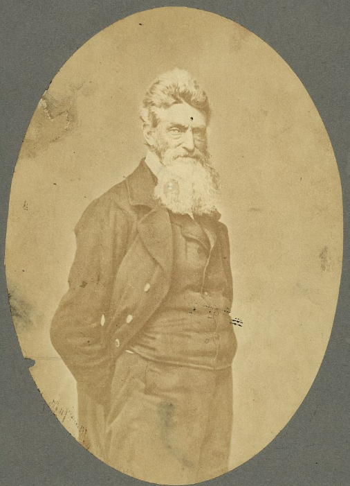
Near the area where the Potomac and Shenandoah rivers meet, a group of nineteen men, led by Captain John Brown, invaded the arsenal at Harpers Ferry. The group then took several of the residents of the surrounding neighborhood as prisoners, while emancipating several slaves, and held off United States troops, under the command of Colonel Robert E. Lee, for almost 30 hours, before finally being captured, wounded, or killed. Captain John Brown was captured, tried, convicted, and executed for high treason and inciting slaves to insurrection. While this endeavor appears to have been a failure, the actions of the Captain and the men who accompanied him helped to launch the United States into the Civil War.
Captain John Brown
Photo by S. Resendez
Because Harpers Ferry was chosen by George Washington to be the location of the 2nd national armory in the US at that time, Harpers Ferry was a prime spot for a faction to seize control. Between 1861 and 1865, the town of Harpers Ferry changed hands eight times. Strategically located at the confluence of two rivers and two railway lines, the arsenal at Harpers Ferry and its strategic location made it a hotbed of invasion and occupation that continued throughout the Civil War. In October of 1867, after the Civil War, Storer College was founded. It became the first higher education institution in West Virginia open to African Americans.
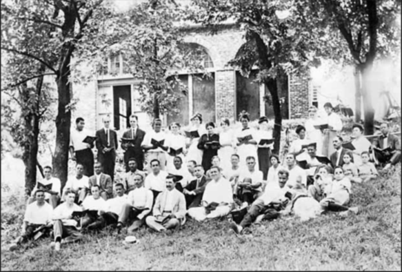
From 1909-1968, John Brown Fort stood on the site of Storer College on Camp Hill in Harpers Ferry. In this circa 1915 photograph, Storer College students, faculty members, and their families pose in front of the fort during an evening choral session. Year: 1915. Image Credit: Historic Photo Collection, Harpers Ferry NHP.
African American families continue to maintain their deep connections to the area in and around Harpers Ferry and today, more than 250 years after the first family settled the area, Jefferson County still boasts the longest established African American community in the state of Virginia.
In 1944, Harpers Ferry National Monument was authorized by Congress and in 1963, the park was renamed Harpers Ferry National Historical Park. Today, Harpers Ferry is not only a significant historical site, it also boasts a wide and varied ecosystem that encompasses a deciduous forest, flood plains, mountains, rivers, streams, wetlands, marshes, and swamps. “The park is home to approximately 14 amphibian,18 reptile, 36 mammal, 30 spider, 43 fish, 174 bird, and 276 insect species.”
Harpers Ferry National Historical Park is open year round with the exception of Thanksgiving Day, December 25, and January 1. The Visitor Center is located at 171 Shoreline Drive, Harpers Ferry, WV 25425 and is open daily from 9a to 5p. Shuttle buses run every day the park is open, every 10-15 minutes. Park museums/exhibits and restrooms in the historic Lower Town are open daily from 9 a to 5 p. Hours change seasonally so make sure you visit the website or call for the most up to date information.
Accessibility: The park has two wheelchairs available that may be borrowed by visitors upon request. The park’s shuttle buses are equipped for those with physical limitations. The buses kneel and have lifts to accommodate those who are unable to utilize the stairs. For more details on accessibility for physical, hearing loss, low vision/blindness, please check the website.
MILE MARKER: Harpers Ferry is an anchor point on the Lewis & Clark National Historical Trail. It served as the starting point for the Corps of Discovery’s journey westward on the Lewis & Clark Expedition in 1803.
HIKE IT!: There are several trails with varying levels of length and difficulty ranging from 1 mile to 6.5 miles long. Be sure to check out the hiking page of the Harpers Ferry NPS website for detailed information on the hikes and the Appalachian Trail!
Loudoun Heights Trail in the fall
Photo courtesy NPS / Volunteer Devin Taggart
We’re covering new ground today as this is our first time exploring an NPS National Historic Trail. Based on the NPS definition of what denotes a National Historic Trail, we learn that a National Historic Trail is a “long-distance route that follows and commemorates a historic path of travel that changed the history and character of the U.S.” Today these routes offer opportunities to visit surviving sites, trail segments, and defining places of history as we learn about the diverse stories they tell. According to the NPS site, there are currently 19 trails that range from 16 miles long to a little over 5,000 miles long. For more information about all the trails, click on the link here.
Map courtesy of NPS
Beginning in Mexico City and winding its way through Texas and up into Louisiana, the Camino Real de Los Tejas covers approximately 2,600 miles. This isn’t a “hikeable” trail by definition, rather it should be considered as a chance to follow the historical footsteps of the people who traveled across countries and through inhospitable lands to begin settling the areas we now recognize as Texas and Louisiana.
Spanish Missions in Texas
Photo by M. Gonzalez
Because we’re writing this from our home base in San Antonio, it’s easy to talk about where the trail leads us from here, but before it got to San Antonio, the trail meandered up from Coahuila, Mexico, near the Rio Grande, to Laredo, Texas, in and around Goliad, Texas (where the Camino Real de Los Tejas museum is located), and up through Victoria and Cuero. From here, the trail veers back towards San Antonio, or continues on to Bryan, Texas. There are also documented starting points, once the border was crossed, in Eagle Pass up to San Antonio. From San Antonio, the road continued on through New Braunfels (which later became a German settlement), up to San Marcos, to Austin or towards Bastrop (home of the Lost Piney Woods). From there, the branches seemed to gather near Crockett and continue on towards Nacogdoches and on towards Louisiana. The Camino Real de Los Tejas split or combined according to the seasons. If the weather affected the planned route, the way could be rerouted to avoid flooded areas or other hazards along the way.
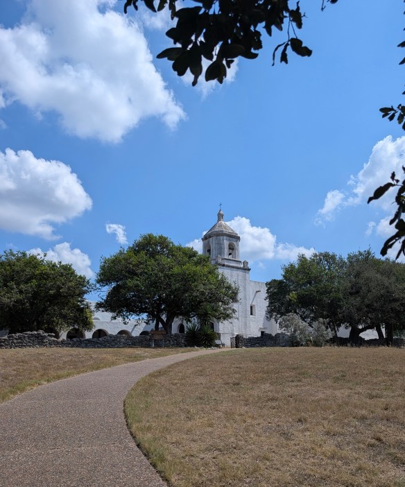
There are several missions along this corridor, some missions having been moved from other areas closer to the Gulf of Mexico, and rebuilt to follow the San Antonio River, going east towards Louisiana or west towards California. In this part of Texas, the most famous missions in and around this area are, arguably, the San Antonio Missions National Historical Park, a UNESCO World Heritage site. However, other missions pepper the way along the Camino Real, such as Mission Nuestra Señora del Espíritu Santo de Zúñiga in Goliad State Park.
Mission Nuestra Señora del Espíritu Santo de Zúñiga
Photo by M. Gonzalez
This amazing spot along the Camino Real showcases the work of the CCC (Civilian Conservation Corp) which was instrumental in building, conserving, and restoring a variety of buildings in and around Texas. While Mission Espiritu Santo was established in the mid-1700’s, it was the fourth mission with the same name and after several relocations, found its final home in the area known as La Bahía, which later became known as Goliad, Texas. As time passed and the mission was no longer needed, Franciscan Priests finally closed this mission in 1830.
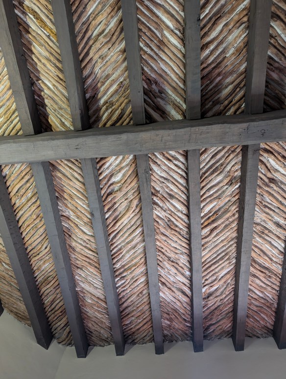
Between 1933-1942, the men of the CCC followed the plans to meticulously reconstruct the mission under the direction of a young architect by the name of Raiford Stripling. But before they would begin their project, they had to work on a “beginner” project in order to ensure that everyone understood the methods used to build the original mission in the 1700’s. In order to practice, they set about making a cottage for the park’s “superintendent to be”. In building this cottage, the men of the CCC could practice their brick making skills, along with learning to work with native materials, and making latilla ceilings (a traditional Southwestern design element consisting of peeled branches or small pieces of wood (latillas) laid between beams (vigas) to create a rustic, decorative ceiling). They learned how to hand carve large, ornate doors and forge iron hinges and once the cottage was finished, they understood what needed to be done to recreate the actual Mission de Espiritu Santo.
Latillas and Vigas
Photo by M. Gonzalez
The Mission Nuestra Señora del Espíritu Santo de Zúñiga is the highlight of Goliad State Park and rightfully so. This mission, reconstructed on top of the its original 1749 foundation and wall remnants, is a testament to architecture and history as we make our way along the Camino Real de Los Tejas on the way to Louisiana.
If you’re interested in learning more about the Royal Road or following in the path of long ago Spanish settlers, look here for a FREE downloadable checklist of places to visit along the Camino Real de Los Tejas.
But there’s more to Goliad, Texas than meets the eye! We’re not done with our stop here just yet because in the midst of traveling this royal road through history, we also find ourselves in the heat of the battle for Texas independence! We’re going to look at, and talk about, flags you might not have known even existed! Stay with the Two Chicks for more adventures in Goliad, Texas!
MILE MARKER: A staircase, carved from two logs, could be placed in tight spaces that might have otherwise only had room for a ladder. Known as “Escaleras de Madera” or Staircases of Wood, they were also sometimes referred to as “Witches Staircases” as folklore denotes the stairs were designed to prevent witches from climbing them.
Escalera de Madera
Photo by M. Gonzalez
HIKE IT!: There is a paved trail that runs through the park and connects the Presidio La Bahía to Goliad State Park and continues on towards downtown Goliad. Within the park, there is a trail that follows alongside the San Antonio River. It’s easy to park in the parking lot at the state park and walk the trail which is relatively flat and accessible. There are also hiking trails at the Medina Valley Natural Area. This area, just south of San Antonio, was part of the Camino Real de Los Tejas and there are some lovely trails to hike along the Medina River.
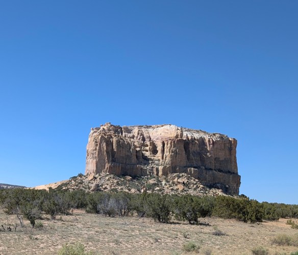
Deep in the high desert of New Mexico, there sits a 367 foot high, sandstone mesa known as Acoma Rock. This is home to Acoma Sky City Pueblo. The ancient Puebloan tribes began to inhabit this mesa, and the surrounding area, as far back as 1150 AD. It is believed that the Puebloans originally inhabited the desert area in and around the mesa until eventually, they found a way to get to the top of the mesa by building crude steps, including hand holds and toe holds, which allowed people to climb up the side of the mesa. Once there, they more than likely realized that its high, isolated location made it virtually impossible to penetrate.
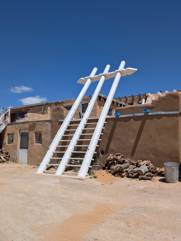
The ancient Puebloans were potters, artisans and architects. The pueblo was a village of roughly 500 three or four stories tall adobe houses. Dwellings were built on the mesa, not unlike those in Mesa Verde, except that the dwellings were not built into cliffs, but on them. People entered buildings via ladders placed through holes in the roof. If materials had to be brought up from the desert or surrounding area, people had to carry everything to construct the buildings up the cliffs on their backs.
Ladder to other worlds
Photo by M. Gonzalez
During the times when the Spanish began their explorations and making their presence known, the Acoma people were able to generally refrain from contact due to their location atop the mesa. When the Spaniards finally made their way to the top of the mesa where the dwellings were located, initial contact was friendly, but over time, as Spanish demands for food and supplies increased, tensions rose. The Acoma people retaliated and months later, the Spanish responded in force, killing over 1500 people. Many survivors were mutilated and forced into slavery and eventually surrendered the pueblo to the Spanish. This lead to the rebuilding of the pueblo under Spanish rule.
San Estévan del Rey Mission Church of Acoma
Photo by M. Gonzalez
Missionaries began their efforts to convert the people to Catholicism and to force them to give up their way of life. The Mission San Estevan del Rey church was built on the mesa in an effort to move the religious agenda forward. The church itself is an amazing structure, especially when you see it for what it is…a place where the people of Acoma could create a flux between Catholicism and their own culture. This is how the church is utilized today. The ceremonies of the people of Acoma are practiced inside the church and the church stands as a testament to the tenacity of the Acoma people and their culture. It is a large, beautiful building consisting of materials that had to be carried up the cliffs on the backs of the enslaved people forced to build it. The roof is held in place by 40-foot long Ponderosa pine vigas, or roof beams, originally hewn in the San Mateo Mountains, 30 miles away. The vigas were carried in by the enslaved people and were not allowed to touch the ground throughout the journey back to the mesa. There is a simple cemetery in front of the church and all the earth used to create that cemetery also had to be brought up the side of the mesa.
Acoma Pueblo
Photo by M. Gonzalez
Acoma was designated a National Historic Landmark in 1960. In 1970, it was placed on the National Register of Historic Places and in 2007, the San Estévan del Rey Mission Church was designated a National Trust Historic Site. It is the only Native American site with that designation. The pueblo consists of approximately 250 dwellings that have held to tradition and currently have no electricity, sewer, or running water. The pueblo is largely uninhabited but there are some families who choose to live there year round. The pueblo is usually filled to capacity during feasts, dances, and community gatherings.
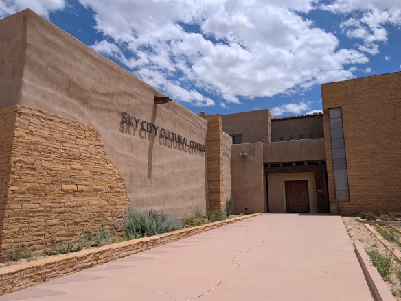
Cultural Center
Photo by M. Gonzalez
Sky City Cultural Center is located approximately 50 miles west on I-40, then another 12 miles on State Route 23. Signs are easily visible once you exit the interstate. The cultural center is open Monday and Tuesday 9am- 4pm and Wednesday- Sunday 9am- 5pm. Monday & Tuesday tour times are 10:30am, 12:30pm, and 2:30pm. Wednesday- Sunday tours start every hour starting at 9:30am to 3:30pm. There are annual closures, and sometimes there are unannounced cultural events that require closure. Weather issues may affect tour times. You can check the website for more details or all 800-747-0181 between 9am to 5pm for specific questions prior to your visit. The price for a tour is approximately $30 at the time of this posting so it may have changed depending on when you’re reading this post. Entry fee includes your photo permit. Your photo permit allows you to take pictures of the pueblo except for inside the Church, within the cemetery courtyard, and during feast days. Permission must be obtained prior to photographing tribal members or their artwork.
Use of tripods, GoPros, video cameras, digital video cameras, binoculars and audio recording devices is prohibited. Commercial use of a photograph depicting Acoma imagery for personal gain (profit) is prohibited. For more information on guidelines, click here.
MILE MARKER: “Acoma is on the Zuni-Acoma Trail, an ancient footpath connecting the old Zuni and Acoma Pueblos. Once used by both native peoples and Spanish explorers, the seven and a half mile-long trail is enjoyed by hikers through New Mexico’s beautiful lava beds. The Zuni-Acoma Trail is part of the El Malpais National Monument, which the National Park Service manages.”~Information courtesy of NPS
Hiking down the mesa
Photo by M. Gonzalez
HIKE IT!: There aren’t any specific trails on the mesa itself, but the guided tour takes about an hour and a half and I logged about one and half miles by the time the tour was finished. If you want to add a bit more adventure to your day, you will be given the option, towards the end of the tour, to take the steps down the side of the cliff and walk back to the Cultural Center. If you’re going there in the summer, be prepared for intense heat. Water and restrooms are only available at the visitor center so bring a hat, wear some sunscreen, and bring some water. Walking sticks help because the terrain in the pueblo is uneven.
Ahhhhh…do you like it steamy?! If so, have we got a place for you!
Photo by S. Resendez
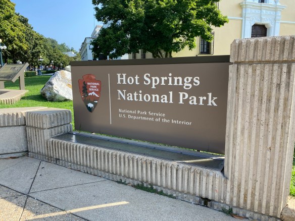
Indigenous people have been quarrying stone from this area of Arkansas for thousands of years. After an exploration expedition in 1804, sent by President Thomas Jefferson, the hot springs were discovered and shortly afterwards, Europeans arrived and began utilizing the geothermal springs. There was talk that the spring waters had healing abilities. A town grew in the area of the springs that later became known as Hot Springs. The resulting bathing industry was built around the geothermal springs coming from the Hot Springs Mountain. This later became known as the “American Spa”.
In 1832, President Andrew Jackson signed legislation to preserve “…four sections of land including said (hot) springs, reserved for the future disposal of the United States (which) shall not be entered, located, or appropriated, for any other purpose whatsoever.” This proclamation meant that Hot Springs National Park was actually the very first, and now the oldest, national park in the current national park sites. Unfortunately, there was no accompanying legislation that prohibited building or settling in or around the area, which meant that people continued to build around and over the springs.
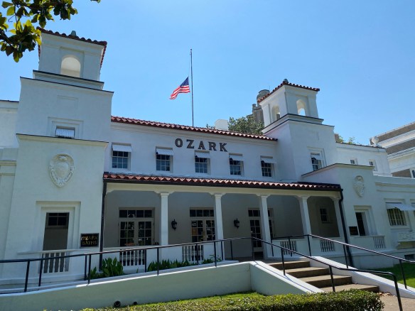
Ozark Bathhouse
Photo by S. Resendez
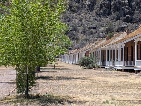
Victorian bath houses built between 1880-1888 were considered large and luxurious, but by the early 1900’s, they were eventually replaced with fire-resistant brick and stucco. This was a precaution due to a severe fire in 1878 which decimated south and central downtown Hot Springs. In contrast to the previous structures, these newly built bath houses featured marble walls, billiard rooms, and gymnasiums. The culmination of changes to Bathhouse Row was completed when the Lamar Bathhouse opened its doors for business in 1923. These bathhouses are all still standing today.
After the Civil War reconstruction era, African Americans found that they could work at the bath houses but they still could not receive services from the bathhouses so they built and maintained many of their own bath houses. African American bathhouse attendants were an integral part of the bathing industry in Hot Springs. They organized to protect their pay and professions from exploitation. And in the early 1900’s, African American residents built the first bathhouse used exclusively by African Americans. For a more in depth look at how African Americans impacted the bathing industry at Hot Springs, visit the NPS link about Bathhouse Attendants at Hot Springs National Park.
The Grand Promenade
Photo by S. Resendez
Take a short walk along the Grand Promenade. This walk runs behind the eight bathhouse buildings that were built between the years 1892-1923. Most of these buildings are open to the public with Fordyce functioning as the park’s visitor center. They can be accessed from Central Avenue. The Fordyce Bathhouse is open every day from 9:00-5:00pm, with the exception of Thanksgiving Day, Christmas Day, and New Years Day.
Today, there are only two bath houses where you are permitted to soak in the springs: the Buckstaff and the Quapaw. There are no entrance fees for the park but because this park encircles a city, you will probably have to pay for parking somewhere in the general area. This is one of the national parks that allows pets! Pets are welcome in the park and on the trails but not in the federal buildings. There is a cell phone tour available for Bathhouse Row so you can stop and listen along the way. If you decide to visit in the summer months, be prepared for the heat! Drink lots of water and wear a hat!
Accessibility: The Fordyce Visitor Center, Gulpha Gorge Campground, other park buildings, and all park bathrooms have functional ramps and are accessible to all persons. Bathhouse Row is paved and has a four to five foot wide walkway that creates a circular loop around the block. There are benches with backs along the Grand Promenade if you need to sit down and rest. There are two wheelchairs available to loan free of charge for use in the Fordyce Bathhouse Visitor Center and Museum. There are tactile exhibits along with self-guided tour books in braille as well as audio descriptions some exhibits and the park films. ASL interpreters are available for guided tours, but you must submit a request two weeks in advance. There are two accessible trails in the park. The Grand Promenade is a half-mile (one-way), fully paved trail with ramp access off Fountain Street and another behind the Fordyce Bathhouse. Whittington Park Trail is a 1.2 mile gravel trail that is a flat but unpaved loop.
MILE MARKER: The water in the hot springs is over 4000 years old! The thermal water that bubbles up in the park today fell as rain over 4,000 years ago. It percolates deep underground, gets heated by the earth’s geothermal energy, and reemerges through the Hot Springs Fault. So when you step into those bathhouses, you’re literally soaking in ancient rainwater!
HIKE IT!: There are over 20 miles of hiking trails in and around the Hot Springs National Park! Levels vary but there are plenty of options for anyone looking to get out of the city and into nature. Paper trail maps can be obtained at the Fordyce Bathhouse and Visitor Center and digital maps with real-time GPS location are available by downloading the service-wide NPS App. Make sure you check at the visitor center before starting your hike just in case there have been any updates or closures.
There are signs that in around 1849, Mescalero Apache watered their horses at the Mescalero Springs. Later, Mexican farmers dug canals by hand to irrigate their crops, which they later sold to people who lived in Fort Davis. The farmers called these springs the San Solomon Springs. In 1927, the springs were dredged and a canal was built to better utilize the flow of the water. Records show that the springs around Balmorhea have been in use for almost 11,000 years.
San Solomon Springs Motor Courts Photo by S. Resendez
In 1934, the State Board of Texas acquired approximately 46 acres around the San Solomon Springs. The Civilian Conservation Corp (CCC) arrived at the springs in July 1934 and began work on building what would later become Balmorhea State Park. The CCC created the 1.3 acre pool around the springs. They also built the concession building, the bath houses, and the motel court using native limestone and hand hewn adobe bricks.
Balmorhea Swimming Pool
Photo by S. Resendez
The San Solomon Springs is the largest in a series of 6 springs located in the Chihuahuan desert. The Balmorhea State Park Swimming Pool is the world’s largest spring-fed pool and often referred to as the crown jewel of the Texas State Parks System. The springs originally emptied into what is known as a ciénga or desert wetland. Construction of the swimming pool, back in 1934, resulted in the destruction of the natural springs which were rebuilt and fashioned into two man-made ciéngas.
Ciénega
Photo by M. Gonzalez
There is an overlook by the RV section of the park for visitors to look for wildlife like deer, javelina, squirrels, turtles, lizards and dragonflies, which also utilize the springs. San Solomon Springs also serves as a stop for resident and migratory birds and is home to several rare and endangered species of snails and fish. San Solomon Springs is the largest spring in the Balmorhea area, and the habitat at Balmorhea State Park is very important for the conservation of these species.
Balmorhea State Park is located at 9207 TX-17, Toyahvale, TX 79786. Daily entrance fee for adults is $7 and free for children 12 and under. Park hours are from 8a to 7:30p or sunset (whichever comes first) and office hours are from 8a-5p. They often reach capacity and highly recommend reservations for both camping and day use. You can reserve passes online or by calling the customer service center before you visit. Check the park’s Facebook page for updates. Read their FAQ page for more detailed information about park and pool rules. Make sure you plan your visit before going!
Chihuahuan Desert Nature Center Entrance Photo by S. Resendez
About 41 miles south and just outside of Fort Davis, Texas, sits the Chihuahuan Desert Nature Center. The Chihuahuan Desert Research Institute (CDRI) is a nonprofit organization that was established in 1973 and housed in Alpine, Texas. Its principal founders were science professors at Sul Ross State University, a university that the institute continues to work closely with today. Today, the CDRI is the Chihuahuan Desert Nature Center and is located on 507 acres in the foothills of the Davis Mountains.
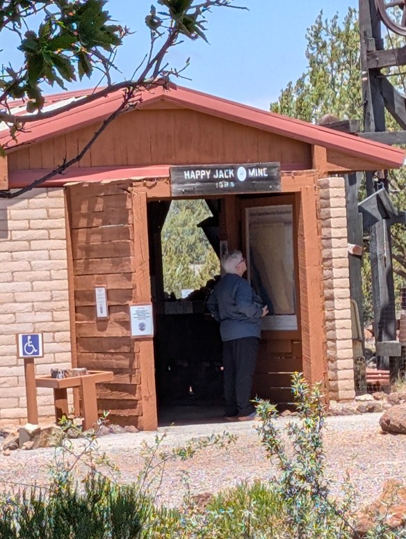
Susan intently studying the locations of the mines!
Photo by M. Gonzalez
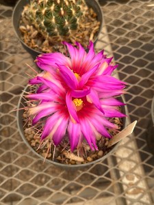
The Nature Center is open year round. If you’re interested in exhibits about geology, history, and culture of the Chihuahuan desert, there is a mining exhibit detailing desert mining and the geological changes that have occurred in the Trans-Pecos of Texas over the last 2 billion years! A bird blind is available for birders, and there’s a cactus museum which houses over 200 species, sub-species, and varieties of cacti and succulents.
Photo by M. GonzalezPhoto by M. GonzalezPhoto by S. Resendez
If you don’t feel like hiking, there are botanical gardens which encompass a wildscape garden, a self-guided stroll through a Trans Pecos Natives garden, a pollinator garden trail, and a native grasses exhibit.
Check the website for Chihuahuan Desert Nature Center before heading out. The Center is located off of Hwy 118, 4 miles SE of Fort Davis at 43869 St. Hwy. 118, Their hours are Monday-Saturday, 9a-5p.
MILE MARKER: Would you believe that cactus can be found as far north as Canada?! Some species have evolved to withstand cold temperatures and dry conditions. Southern prairies and certain regions by the Great Lakes, provide habitats with enough sun, well-drained soil, and suitable temperatures for cacti to thrive.
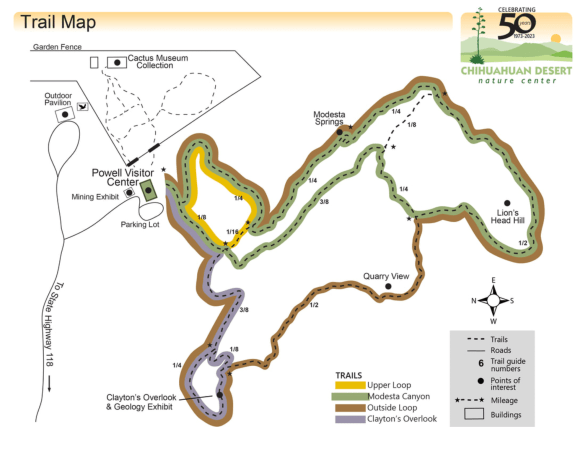
HIKE IT!: There are lots of great hiking trails at the Chihuahuan Desert Nature Center. There are 5 trails ranging from .25 mile (scenic loop inside the botanical garden) to a 2.5 mile loop, which is considered a strenuous hike. Remember, you are hiking at an elevation of approximately 5,000 feet! Consider the weather and your own physical abilities. While the trails are mostly earthen, they may be uneven so take your hiking sticks, sunscreen, a good hat to cover your head and face, and plenty of water. After all, you’re desert hiking!
Trail Map for CDNC
Photo courtesy of Chihuahuan Desert Nature Center
Minidoka, one of ten incarceration sites established during World War II, stands as a powerful reminder of the injustices faced by Japanese Americans forcibly removed from their homes during the onset of World War II.
In the 1880’s, Japanese immigrants began making their way to America, primarily to Hawai’i, where they worked in the sugar plantations. From there, many Japanese immigrants made their way to the mainland where they worked clearing mines, building the railroad, at sawmills, and in the fields. This was due in part to The Chinese Exclusion Act of 1882, which was the first significant law prohibiting immigration of Chinese laborers for 10 years.
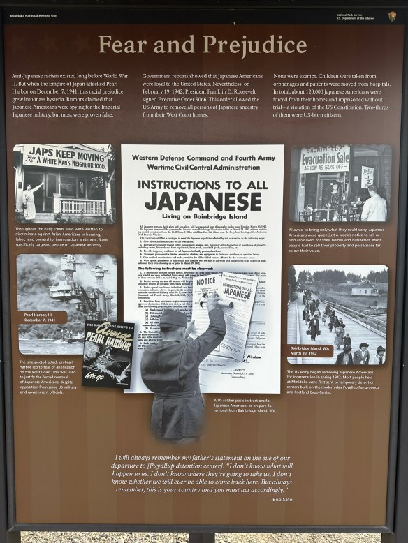
By the early 1900’s, Japanese families had assimilated into American culture. With a strong presence in Hawai’i and along the entire west coast of the United States, Japanese American families were fully productive members of society. They were business owners, educators, entrepreneurs, and neighbors. Despite lingering racist sentiment, much of it stemming from the Asian Exclusion Act of 1924, Japanese-American families had tentatively created a place for themselves in America. Then, on December 7, 1941, Imperial Japan launched an unprovoked attack on Pearl Harbor. The United States declared war with Japan and life for Japanese Americans immediately changed.
Photo by S. Resendez
Predicated by the Asian Exclusion Act of 1924, on February 19, 1942, President Franklin D. Roosevelt signed Executive Order 9066, declaring certain areas within the United States as “war zones” thus enacting the removal of any and all Japanese Americans from their homes, forcing them into imprisonment without the benefit of due process. This remained in effect for the duration of the war. Despite some opposition and varied court cases filed against it, the executive order was not overturned until 1944.
Japanese Americans were first sent to temporary detention facilities, usually animal stables, racetracks, or fair grounds, and were held there until they were transported to their assigned War Relocation Camp. Ten major camps were set up for Japanese-American relocations. Minidoka was just one of them.
Minidoka National Historic Site is located in Jerome, Idaho, in the south-central part, not too far from Twin Falls. The concentration camp sat on approximately 33,000 acres and housed approximately 13,000 people, mostly from Washington, Oregon, and Alaska. The compound consisted of over 600 buildings, including the barracks where families lived. Before families arrived at Minidoka, they were given little to no notice that they had to vacate their homes. They were not allowed to bring anything they could not carry themselves.
Upon arrival at Minidoka, the prisoners learned that the camp was barely able to house all the incoming. Barracks had been hastily built using green wood and tar paper. One young man wrote of getting off the bus and walking into a dust storm. The minimally built shelters did nothing to keep out the elements as the green wood shrank and created gaps for the wind, dust, and rain to get through. There was no privacy in the large, shared buildings, and as an added insult to injury, prisoners were forced into labor, building more of the barracks that would be needed to house the hundreds of people coming in daily. Even the plumbing and sewage system wouldn’t be completed for several months. Across the nation, over 120,000 people were forced to live in these camps, in horrific conditions, with many of them being U.S. citizens,
Photo by S. Resendez
Minidoka consisted of 36 residential blocks with 12 barracks, a mess hall, and a latrine. Each barrack was 120’x 20’, which was divided into six units. Each unit housed a family or a group of individuals. Each unit had one lightbulb and one coal burning stove. The walls dividing the units did not extend to the ceiling and the barracks had no insulation. Bathrooms consisted of a row of toilets and a row of showers. There were no partitions or dividing walls. Each block held a mess hall which served as a “hub” of sorts for families to gather and eat and hold community events like holiday parties or dances.
While not ideal, the families and individuals living within the concentration camp made the best they could of their situation. They educated their children in makeshift schools. They created sports teams, building a baseball field and basketball courts so they could play. They hosted cultural events amongst themselves, held religious services, and even published their own newspaper. The Japanese American people proved to be resourceful as well as resilient.
Baseball Field
Photo by S. Resendez
While in the concentration camps, males were offered the “opportunity” to serve their country as long as they signed acknowledgment and swore “unqualified allegiance” to the US and that they also forswore allegiance to any foreign power, including the Japanese Emperor. Most of the interred men wanted to serve their country but were angry at having to declare their allegiance to a country for which they never gave up their allegiance. How could they renounce allegiance to an emperor they never swore allegiance to in the first place? In the end, the men who decided to answer “no” to the questions regarding their allegiance were removed from the internment camps and sent to high security camps or detention centers. Most of the 30,000 Japanese American men who saw battle became part of 442nd Regimental Combat Team and the 100th Infantry Battalion, with many still who became part of the Company B of the 1800th Engineering Battalion. In all, they were awarded six Distinguished Service Crosses during the first eight weeks of combat and three Presidential Unit Citations. Eventually, joining the 442nd Combat Team and the 100th Infantry Battalion, Company B of the 1800th Engineering Battalion is often recognized as the most decorated American unit for its size and length of service.
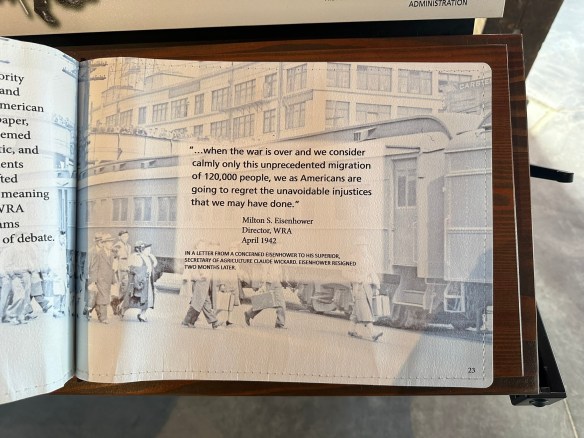
“Americans are going to regret the injustices that we may have done.”
Photo by S. Resendez
In late 1944, in the case of Ex parte Mitsuye Endo, the Supreme Court ruled that Executive Order 9066 was unconstitutional. Also being reviewed by the Supreme Court in 1944, was the case Korematsu v. United States. In this case, (which was happening at almost the exact, same time as the Mitsuye Endo case) the use of the internment camps was upheld and is often cited as “one of the worst Supreme Court cases of all times”. In his dissent, Justice Frank Murphy said this,
I dissent, therefore, from this legalization of racism. Racial discrimination in any form and in any degree has no justifiable part whatever in our democratic way of life. It is unattractive in any setting, but it is utterly revolting among a free people who have embraced the principles set forth in the Constitution of the United States. All residents of this nation are kin in some way by blood or culture to a foreign land. Yet they are primarily and necessarily a part of the new and distinct civilization of the United States. They must, accordingly, be treated at all times as the heirs of the American experiment, and as entitled to all the rights and freedoms guaranteed by the Constitution.~~Korematsu v. United States, 323 U.S. 214 (Supreme Court of the United States 1944)
When the camps closed and the prisoners were released, they were given the paltry sum of $25 and a one-way bus or train ticket to the destination of their choice. Despite the fact that the war was over and the despite the fact that Japanese Americans fought for their country alongside other American soldiers, anti-Japanese sentiments made integrating back into their communities difficult.
Life After Minidoka
Photo by S. Resendez
After the war ended, President Truman signed the Japanese American Evacuation Claims Act of 1948. This entitled anyone who was incarcerated to file claims for damages and loss of property but reparations did not come close to the $148 million dollars claimed. Only $37 million dollars had been allocated for damages. After the Civil Rights Movement, reparations were again sought and in 1980, the commission on Wartime Relocation and Incarceration of Civilians was signed into law. They discovered that the incarceration was the result of “racial prejudice, wartime hysteria, and a failure of political leadership.” In 1988, the Civil Liberties Act of 1988 was formalized, with President Ronald Reagan formally acknowledging the unconstitutional nature of the internment camps. Japanese Americans who were wrongfully imprisoned finally received reparations of $20,000 along with a formal apology.
Survivors and family members, friends, and allies of the people who were incarcerated at Minidoka participate in an annual pilgrimage. To learn more about their pilgrimage, click here.
The Minidoka Visitor Center is located at 1428 Hunt Road in Jerome, Idaho. If the visitor center is not open during your visit, you can check the after hours box for brochures. The historic site grounds are open year-round for self-guided walking tours. The Visitor Center is open Friday, Saturday, and Sunday from 10a to 5p. Restrooms are unavailable if the Visitor Center is closed.
The books mentioned in the podcast are Facing the Mountain: A True Story of Japanese American Heroes in World War II by Daniel James Brown and The Train to Crystal City: FDR’s Secret Prisoner Exchange Program and America’s Only Family Internment Camp During World War II by Jan Jarboe Russell
MILE MARKER: Despite the limited rations given at the internment camp, residents created gardens, grew crops, built hog and poultry farms and became completely self-sustainable. They even managed to create their own tofu plants.
HIKE IT!: Minidoka National Historic Site offers 1.6 miles (2.5 km) of gravel walking trails which is basically a self-guided tour of the grounds. It is essentially flat and not difficult to navigate on foot. It is not considered an “accessible” trail. There is plenty to see and read along the route. The sign boards offer stories of information regarding the activities on the land.
Imagine yourself in the middle of a desert, surrounded by nothing but harsh cliffs, scrub brush, cactus, and sandy caliche. There is a dusty road stretching out from east to west and there is no sign of civilization as far as the eye can see.
Okay, this isn’t the actual road but you get the idea. (This is a road in the same general area, though.) Photo by M. Gonzalez
This is the Chihuahuan Desert. The largest desert in North America. It stretches from northern Mexico to the southwestern US, running through southwest Texas, New Mexico, and parts of Arizona. It covers approximately 200,000 square miles and while the average elevation is only 1000 feet above sea level, elevations can range from 3,500 to 5,000 feet.
In the mid-1800’s, if you wanted to travel from San Antonio, Texas to El Paso, Texas or further onto California to join the gold rush, this was the route you had to take. It was referred to as the Trans-Pecos Trail, specifically the San Antonio-El Paso road on the Chihuahua Trail.
Park Entrance Photo by S. Resendez
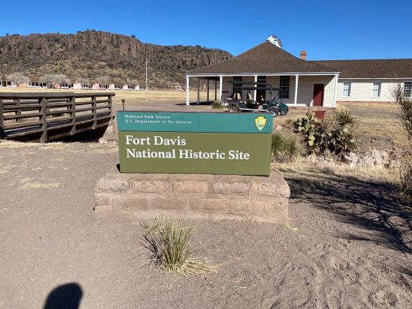
In 1854, Fort Davis was established to create a point of protection for travelers, freighters, and mail carriers. The Eighth U.S. Infantry was stationed at Fort Davis until 1891. Fort Davis, named after Secretary of War, Jefferson Davis, was instrumental in protecting, defending, and developing the western frontier. The post was situated in a box canyon in the shadow of the Davis Mountains, (known then as the Limpia Mountains). With the onset of the Civil War and the secession of Texas, Fort Davis was abandoned and stayed deserted for five years.
The original post was built quickly and was poorly constructed. After the civil war, in 1867, Fort Davis, once again, became an active post. New buildings were constructed, eventually adding a guardhouse, barracks, officer’s quarters, a temporary hospital, and storerooms. Construction went on through the 1880’s, eventually housing up to 400 soldiers.
Housing at Fort Davis Photo by M. Gonzalez
Commanches and Apaches continued to make the road hazardous travel for mail carriers and travelers, so soldiers spent the majority of their time patrolling the road and fighting off the Apache, as the Commanche had been defeated years earlier. The Apache, led by their leader, Victorio, were pushed into Mexico where, after eluding US troops for over a decade, they were finally captured and killed.
In June of 1891, Fort Davis was ordered to shut down and was abandoned, having outlived its usefulness. In 1961, the fort was authorized as a national historic site, a unit of the National Park Service.
Before we travel onto the Davis Mountains State Park, we would be remiss if we didn’t delve a tiny bit into what an integral part the Buffalo Soldiers played in the formation, maintenance, and safety of Fort Davis and the San Antonio-El Paso Road.
Following the Civil War, as Fort Davis was recommissioned, Troops from the Ninth U.S. Cavalry, the Buffalo Soldiers, were the first to report. They helped to reconstruct the fort, faced down conflicts with the Apache and the Comanche, and protected the mail, as well as travelers, on the San Antonio-El Paso road. The Buffalo Soldiers were integral in the day to day functions of Fort Davis. In addition to providing protection to travelers and escorting freight and mail, they repaired military telegraph lines and guarded water holes.
Even though the civil war was over, the Buffalo Soldiers still faced discrimination. Troops were segregated and rations and equipment were given to the white troops first, with the black troops receiving whatever was leftover. Despite all this, the Buffalo soldiers proved to be a force for keeping West Texas in check. They became known as the peacekeepers of the area and were highly revered by the Native Americans for their fierce fighting skills. It was the Native Americans who nicknamed these regiments, “Buffalo Soldiers”. The African-American soldiers accepted the name and adopted the Buffalo as a symbol of honor.
On a side note, in addition to keeping the peace in West Texas, active units of the Buffalo Soldiers served from 1866 until 1952. While remaining segregated, the Buffalo Soldiers served and fought in the Spanish-American War, protected the U.S. during the Mexican Revolution, World War I and World War II, as well as the Korean War.
Now, let’s make our way to the Davis Mountains State Park. It’s about a 10 minute drive from Fort Davis. Once you’re on the grounds, you will find yourself in an expansive state park of approximately 2,700 acres that reaches elevations of up to 6,000 feet! It may not seem like it, but this park is busy, especially beginning in the spring to the late summer. Camping is available but reservations are suggested, for camping AND day use, especially during their busy season.
Pullout view from Skyline Drive Photo by M. Gonzalez
There are many things to see and do at Davis Mountains State Park. You can go camping, hiking, backpacking, mountain biking, and if you have one, you can bring your horse and hit the trails! There’s a scenic drive that winds its way up the mountains for some spectacular views. If you’re there at night, or almost anywhere in this general area, star gazing is at its best. (The McDonald Observatory is nearby so you could book a star party with some friends if you really want to take advantage of the dark sky!)
In addition to all of the nature and the views, there are a couple of shops available, the smaller shop being at the park entrance office and the larger shop located at the Indian Lodge which is further into the park.
If you plan on spending several days in and around this area of west Texas, why not check to see if there are any rooms available at the The Indian Lodge? The Lodge has been recently renovated and would be a wonderful place to stay while you explore the area.
As you make your way to the top of Skyline Drive, take a minute to stop at the Interpretive Center. This short stop is worth your time if you have any interest in the park’s wildlife, geology, or history. And if you’re a birder, you’re really going to love stopping here because they have an indoor bird blind which allows you to sit in air conditioned comfort while you watch the birds fly in and out. There are also has GPS Units available for loan if you plan on hiking in the park. Please say hi to Charlie if you go by the Interpretive Center. He’s a wealth of information!
The top of Skyline Drive
Photo by M. Gonzalez
After your stop, continue towards the top of Skyline Drive, where you can park and take in the expansive views.
There is so much more to write about this park and its history but it’s just too much to cover. Take some time to visit their website. It’s got a wealth of information about everything the park has to offer. It also has alerts about things you may need to be aware of as you plan your trip. Make sure you check the website!
MILE MARKER: Cathay Williams was the first documented female buffalo soldier! She served from 1866-68. Since women were not allowed to serve then, Williams disguised herself as a man to enlist in the army. Read more about her history and more about the Buffalo Soldiers at the Bexar County Buffalo Soldiers Association.
HIKE IT!: There are several trails to choose from if you decide to hike while at Davis Mountains State Park. Check the website for details on length and difficulty. If you’re planning a visit to the Fort Davis National Historic Site, there’s a hiking path that connects both parks. It would be our recommendation, if you’re a less experienced hiker, especially if you’re hiking in higher elevations than you may be used to, that you study the details of this hike and make your decision based on your experience. While it is a relatively short hike (approximately 1 mile), you will be encountering an elevation drop on your way to Fort Davis and an elevation gain back to where you parked at the Davis Mountain State Park.
Remember, you’re in the mountains!! Most of these trails will incur elevation drops and elevation gains. You’re also in a desert, so hike wisely. Start your hikes early in the morning and take more water than you think you may need. Borrow a GPS unit from the Interpretive Center if it makes you feel more confident. Click here for an interactive map of the Davis Mountains State Park Trails. Be safe and have fun!
Canyon de Chelly was authorized in 1931, but its roots go back further than our imaginations can carry us.
Initially inhabited by Ancient Puebloans until the mid-1300’s, they were followed by the Hopi, and in the mid-1600’s, the lands were finally settled by the Navajo, also known as the Diné.
The Navajo were able to prosper in the canyons, raising their families, farming crops, planting orchards, and caring for livestock, until the late 1700’s when many external forces created challenges to their ability to live on their rightful land. Invasions by the Ute, other tribes, and Spanish colonists challenged Navajo defenses, which were eventually overrun.
The Navajo built their lands up again, only to be assailed in the 1860’s by Col. Kit Carson of the U.S. Army, who utilized a scorched earth policy to decimate the land and forced the Navajo people to leave their home and walk 300+ miles over a span of 3 years. The Navajo, as well as the Mescalero Apache, were forcibly removed from their homelands and “relocated” to an outpost known as the Bosque Redondo Indian Reservation, which was intended to be a reservation but quickly became a prison camp. Lack of rations, disease, and horrific living conditions resulted in the deaths of approximately 1500 people, not including those who perished during the Long Walk to Bosque Redondo.
In 1868, a treaty was signed acknowledging the sovereignty of the Navajo Nation and the Navajo people were allowed to return to their land. In 1931, President Herbert Hoover authorized the Canyon de Chelly National Monument. Canyon de Chelly covers approximately 84,000 acres, all of which resides fully in the Navajo Nation. There are still at least 40 families residing within the boundaries of the park. The Navajo people and the National Park system share resources and work in tandem to preserve this beautiful monument.
Canyon de Chelly has no entrance fee! There is a Welcome Center with a park store. The entrance gates are open from 8a-5p daily except for Thanksgiving, Christmas and New Year’s Day.
Plan ahead to learn more about the scenic drives. There are two paved, rim drives with several overlooks. The North Rim Overlook offers views of the cliffside dwellings and the South Rim offers more scenic views including a view of Spider Rock.
Each drive takes approximately 2 hours, according to the park website, so plan for a 2-4 hour trip if you plan on making all stops for photo opportunities. The park website provides suggestions for what to see depending on how much time you’ve allotted for your visit.
Primitive campsites are available for a fee. Self-guided hikes and Ranger led programs are available but check before hand for changes in fees and schedules. Private canyon tours are available by hiking, horseback or vehicle. As with other parks and sites where people are currently in residence, please look out for and respect any signs that prohibit taking photographs.
MILE MARKER: The Navajo and Apache people are Athabaskan speakers. They are distantly related to the Athabaskan people from Canada and Alaska.
HIKE IT!: The White House Ruins Trail is a 2.5 mile, round trip hike that descends 600 feet into the canyon. This is the only self-guided tour at Canyon de Chelly and although it is currently closed, there are plans to reopen the trail sometime in 2025.
Last week, we shared our visit to The World Heritage Center and introduced you to the Mission Trail. This is a Hike & Bike Trail that connects all the San Antonio Missions. This trail is an out and back trail that is approximately 14 miles long. After we finished up there, we made our way to the Padre Margil Pilgrimage Center.
Before we talk a little bit about the Pilgrimage Center, it is worth the time to learn about, and possibly introduce you to The Camino de Santiago, also known as The Way of St. James. The Camino is a pilgrimage that starts from various places, all over England and Europe, but every route leads the pilgrim to their final destination, the Church of St. James.
Until 2018, when the Camino de San Antonio Missions became a recognized part of El Camino de Santiago, there were no other formally recognized routes to the Camino outside of Europe. It is a great honor for San Antonio Missions to be formally recognized as part of the Camino!
The Way of St. James, has many starting points and these starting points are reflective of the route the Pilgrim takes as they make their way to their final destination. For example, the Camino Frances, or The French Way, which is the most common route, begins at the base of the Pyrenees Mountains in France and traverses across the northern part of Spain towards St. James. The Camino Portugués, or The Portuguese Way, begins in the southern part of Portugal and makes its way north to the church of St. James. And, The Camino Ingles, or the English Way, begins from one of two traditional starting points, either Ferrol or Coruña, and makes its way south to St. James Church. The English Way is named the English Way (even though both starting points are in Spain) for Pilgrims who began their pilgrimage in England and Ireland.
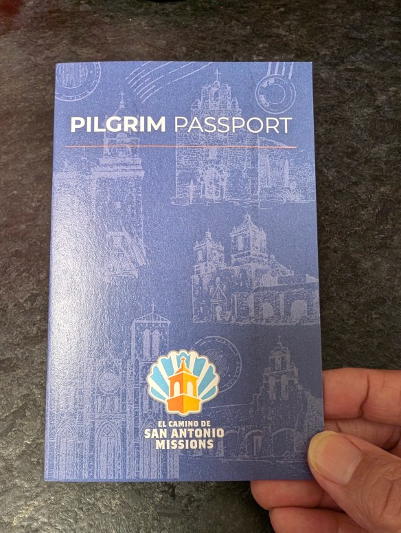
In order for your journey to count towards accreditation, you are required to have travelled at least the last 100 km on foot (or the last 200 km by bicycle), which is demonstrated by the “Credencial del Peregrino” which you have had stamped along the route travelled. The Credencial or Credential, is a sort of “passport” you receive upon starting your pilgrimage. While traveling along The Way, there are places known as albergas that are available for Pilgrims to spend the night as they journey towards St. James. Upon arrival at an alberga, you present your Credencial and receive a stamp to acknowledge that you stayed there on your way to St. James. At the end of your journey, you submit your Credencial as proof of your Pilgrimage and receive a Compostela, or accreditation, at the culmination of your journey.
El Camino de San Antonio Missions is a way to link your journey on the Camino de Santiago. Travel by foot on the Camino de San Antonio, traveling to all four Missions and the San Fernando Cathedral. Completing this journey counts as 30 km towards the Camino Ingles in Spain. Continue your Camino in Spain beginning in Ferrol and complete the remaining 70 km to complete the required 100 km towards your Compostela. From the official website: “If a pilgrim has already started a route on foot outside Spain along one of the routes recognized by the International Pilgrim’s Reception Office system, the required distance in Spain shall be no less than 70 kilometers.” Get more detailed information about the Pilgrimage and all the available routes at website of El Camino de Santiago.
For more details on the San Antonio portion of the Pilgrimage, visit the website for El Camino de San Antonio.
The Pilgrimage Center is a bright and welcoming, place with a small shop and a small cafe. There’s nothing fancy in the cafe but it’s a good place to grab a drink and a snack if you’ve been walking. There are tables outside in some shady areas to sit and relax for a bit. There’s not really a museum, per se, but there are some touch screens with some interesting information about a variety of subjects, including the Camino de San Antonio, the Camino de Santiago, the Riverwalk, and other areas of interest. There is also a display entitled “Hands in Prayer” showcasing the meaning and use of strings of beads from different religions. There are places where children can do a “craft” of sorts creating ropes of beads. The building is a welcome place to sit and refresh on a hot day. The shop has some nice items in it. Buying a small souvenir helps to support the center so it’s all for a good cause. This is also where you will buy your Pilgrim Passport. For $10 you get your passport and a keychain. The fully stamped passport is what you will need to receive your Compostela upon completion.
MILE MARKER: Compostela means Field of Stars. It comes from the Latin “campus stellae” and is based on the stars of the Milky Way that, according to legend since the Middle Ages, had been outlined by the apostle St. James and followed by pilgrims to reach his tomb.
HIKE IT!: The Camino de San Antonio Missions is approximately 19-20 miles. The route does not have to be completed in one day and can be completed in sections. The route can be completed from north to south, or south to north. If you think you may ever travel to Spain to complete your Camino, register on the San Antonio website for your Compostela. Don’t forget, summer months can be brutally hot, so remember to bring plenty of water and sunscreen. See our downloadable checklist for ideas on what to bring for a city hike.
On July 5, 2015, the five San Antonio Missions were designated the first UNESCO World Heritage site in Texas. The San Antonio Missions National Historical Park ensures that these treasures are preserved for future generations. Through guided tours, museum exhibits, and cultural events, the stories of the missions come alive, inviting visitors to reflect on the enduring legacies of cooperation, adaptation, and perseverance.
The San Antonio Missions tell the stories of the people who came into the Spanish missions to live in the 1700s. Acculturating and converting the Indigenous population in order to become Spanish citizens reverberates today in the southwest United States. Our history is part of who we were, who we are, and who we will be. The National Park Service invites you to discover American history in all its diversity at San Antonio Missions National Historical Park.
Other mission sites, such as those in Goliad and Nacogdoches, are maintained by state parks and local organizations, each contributing to the preservation of Texas’ rich history. Efforts to document and restore these sites ensure that the diverse narratives they hold are not lost to time.
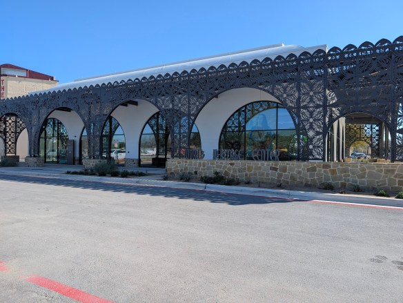
The City of San Antonio World Heritage Office manages the World Heritage Center, Mission Marquee Plaza, and the Spanish Governor’s Palace. On February 7, 2025, the World Heritage Center opened its doors to the public. Set on the site of the former Mission San José farmland, The Center is a doorway, not only to the San Antonio Missions, but to the neighborhoods surrounding them. The Center provides visitor orientation, informs the community about the World Heritage Designation, and honors the legacies of the people connected to our World Heritage missions, in particular our mission descendants.
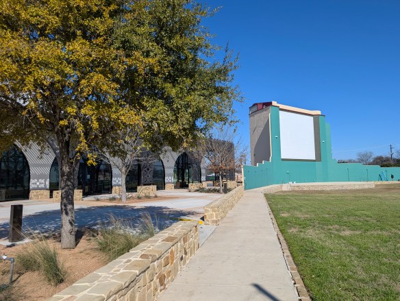
Upon arriving at The Center, the first thing you might notice, and truly appreciate (especially if you’re from San Antonio) are the grounds. The Center is set on the site of the former historic Mission San Jose farmland and the former Mission Drive-In Theater. They have retained the original facade of the old Mission Drive-In Theater. There is a large, grassy field in front of one of the old screens and the old concession stand is still there. The area is now referred to as Mission Plaza and also includes a public library and YMCA.
Mission Marquee Plaza, formerly known as the Mission Drive-In Theatre is open to the public and hosts a variety of free City of San Antonio events and various programs throughout the year.:
Movie Nights: Every 1st and 3rd Saturday (May-Nov.) — Movies begin at dusk
Throwback Thursday Movie Nights: Every 3rd Thursday (May-Nov.)
For more details and information about Mission Marquee Plaza, please check their website.
World Heritage Center Veranda
Photo by M. Gonzalez
Moving to The Center, there are beautiful, large, glass windows and an ornate, scrolling metal wall, also referred to as The Veranda. The Veranda was designed by local artist Adriana Garcia, and is also a Tricentennial Celebration Commission’s Legacy Gift to the citizens of San Antonio. The Plaza is easy to find with the San Jose Mission’s silhouette in the background.
The Center is a small museum with with interactive video boards, interpretive displays, and life-sized displays of regalia. It has enough information to keep visitors interested for at least 30 minutes or longer. Children might have some interest but there’s probably not enough there to keep a young child engaged. There are publications available to all visitors, most collectible is a very nice brochure highlighting the San Antonio River Walk. There is also a brochure featuring World Heritage Sites in the US. They will also, eventually, have a small gift shop.
Whether you’re a history enthusiast, a nature lover, or simply seeking a connection to the past, the Spanish Missions of San Antonio, Texas offer an unparalleled journey. Walk through the arched corridors, listen to the whispers of history in the mission chapels, and let the spirit of this remarkable heritage inspire you. Here, the past is not just remembered but celebrated, a testament to the resilience and creativity of those who came before.
Visit the San Antonio Missions! Choose one or make a full day of it.
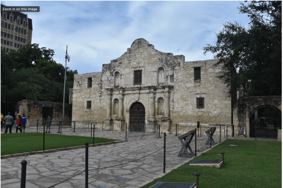
The Alamo: The most recognizable of all the San Antonio Missions is The Alamo. Originally referred to as Mission San Antonio de Valero, the most recognizable part of the building was the chapel. The grounds continue to develop and grow as more and more history is discovered and as new information is brought to light.
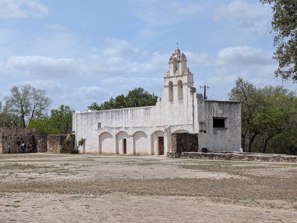
Mission Concepcion: Mission Concepcion is considered to be the oldest, unrestored church in the United States. It is an active Catholic Church serving as a parish within the Archdiocese of San Antonio. There are several frescos still visible on the walls of the church, including the famous “Eye of God”. Mission Concepcion grounds also house the Padre Margill Pilgrimage Center.
Mission San Juan: Mission San Juan de Capistrano was originally founded in East Texas and moved to San Antonio in 1731. There is a short trail behind the mission, the Yanaguana Trail, that leads to the San Antonio river.
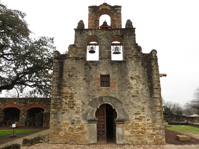
Mission Espada: Mission Espada is an active parish, meaning it still functions as a Catholic church. It is the oldest of all the San Antonio Missions and the first Mission to be founded in Texas in 1690. It was relocated from the Houston area in 1731.
The World Heritage Center is located at 3106 Roosevelt Ave., 78214. They are open from 10a to 5p on Tuesdays, Wednesdays, & Fridays. They are open from 10a to 8p on Thursdays, and from 10a to 5p on Saturdays & Sundays. They are closed on Mondays.
MILE MARKER: In 2024, Mission San José along with 18 other sites in 10 states have been added to the National Underground Railroad Network to Freedom today which recognizes places and programs with verifiable connections to the Underground Railroad and the resistance to enslavement through escape and flight.
HIKE IT!: There is a Hike & Bike Trail that connects all the San Antonio Missions. This trail is an out and back trail that is approximately 14 miles long. There are approximately 2.5 miles between missions on this trail and it can be completed in one day or broken up into segments. Summer months can be extremely hot, so remember to bring plenty of water and sunscreen.