Imagine yourself in the middle of a desert, surrounded by nothing but harsh cliffs, scrub brush, cactus, and sandy caliche. There is a dusty road stretching out from east to west and there is no sign of civilization as far as the eye can see.

Photo by M. Gonzalez
This is the Chihuahuan Desert. The largest desert in North America. It stretches from northern Mexico to the southwestern US, running through southwest Texas, New Mexico, and parts of Arizona. It covers approximately 200,000 square miles and while the average elevation is only 1000 feet above sea level, elevations can range from 3,500 to 5,000 feet.
In the mid-1800’s, if you wanted to travel from San Antonio, Texas to El Paso, Texas or further onto California to join the gold rush, this was the route you had to take. It was referred to as the Trans-Pecos Trail, specifically the San Antonio-El Paso road on the Chihuahua Trail.
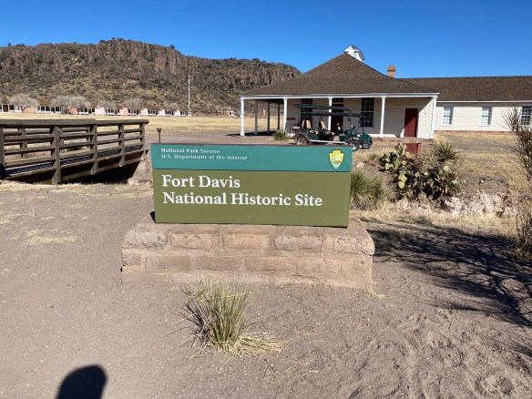
Photo by S. Resendez
In 1854, Fort Davis was established to create a point of protection for travelers, freighters, and mail carriers. The Eighth U.S. Infantry was stationed at Fort Davis until 1891. Fort Davis, named after Secretary of War, Jefferson Davis, was instrumental in protecting, defending, and developing the western frontier. The post was situated in a box canyon in the shadow of the Davis Mountains, (known then as the Limpia Mountains). With the onset of the Civil War and the secession of Texas, Fort Davis was abandoned and stayed deserted for five years.
The original post was built quickly and was poorly constructed. After the civil war, in 1867, Fort Davis, once again, became an active post. New buildings were constructed, eventually adding a guardhouse, barracks, officer’s quarters, a temporary hospital, and storerooms. Construction went on through the 1880’s, eventually housing up to 400 soldiers.
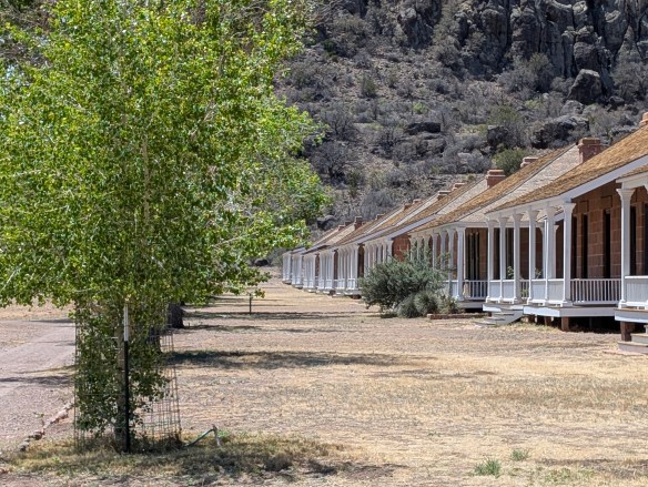
Photo by M. Gonzalez
Commanches and Apaches continued to make the road hazardous travel for mail carriers and travelers, so soldiers spent the majority of their time patrolling the road and fighting off the Apache, as the Commanche had been defeated years earlier. The Apache, led by their leader, Victorio, were pushed into Mexico where, after eluding US troops for over a decade, they were finally captured and killed.
In June of 1891, Fort Davis was ordered to shut down and was abandoned, having outlived its usefulness. In 1961, the fort was authorized as a national historic site, a unit of the National Park Service.
Before we travel onto the Davis Mountains State Park, we would be remiss if we didn’t delve a tiny bit into what an integral part the Buffalo Soldiers played in the formation, maintenance, and safety of Fort Davis and the San Antonio-El Paso Road.
Following the Civil War, as Fort Davis was recommissioned, Troops from the Ninth U.S. Cavalry, the Buffalo Soldiers, were the first to report. They helped to reconstruct the fort, faced down conflicts with the Apache and the Comanche, and protected the mail, as well as travelers, on the San Antonio-El Paso road. The Buffalo Soldiers were integral in the day to day functions of Fort Davis. In addition to providing protection to travelers and escorting freight and mail, they repaired military telegraph lines and guarded water holes.
Even though the civil war was over, the Buffalo Soldiers still faced discrimination. Troops were segregated and rations and equipment were given to the white troops first, with the black troops receiving whatever was leftover. Despite all this, the Buffalo soldiers proved to be a force for keeping West Texas in check. They became known as the peacekeepers of the area and were highly revered by the Native Americans for their fierce fighting skills. It was the Native Americans who nicknamed these regiments, “Buffalo Soldiers”. The African-American soldiers accepted the name and adopted the Buffalo as a symbol of honor.
On a side note, in addition to keeping the peace in West Texas, active units of the Buffalo Soldiers served from 1866 until 1952. While remaining segregated, the Buffalo Soldiers served and fought in the Spanish-American War, protected the U.S. during the Mexican Revolution, World War I and World War II, as well as the Korean War.
Now, let’s make our way to the Davis Mountains State Park. It’s about a 10 minute drive from Fort Davis. Once you’re on the grounds, you will find yourself in an expansive state park of approximately 2,700 acres that reaches elevations of up to 6,000 feet! It may not seem like it, but this park is busy, especially beginning in the spring to the late summer. Camping is available but reservations are suggested, for camping AND day use, especially during their busy season.

Photo by M. Gonzalez
There are many things to see and do at Davis Mountains State Park. You can go camping, hiking, backpacking, mountain biking, and if you have one, you can bring your horse and hit the trails! There’s a scenic drive that winds its way up the mountains for some spectacular views. If you’re there at night, or almost anywhere in this general area, star gazing is at its best. (The McDonald Observatory is nearby so you could book a star party with some friends if you really want to take advantage of the dark sky!)
In addition to all of the nature and the views, there are a couple of shops available, the smaller shop being at the park entrance office and the larger shop located at the Indian Lodge which is further into the park.
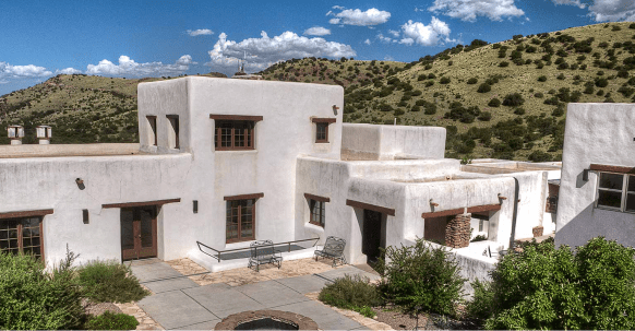
If you plan on spending several days in and around this area of west Texas, why not check to see if there are any rooms available at the The Indian Lodge? The Lodge has been recently renovated and would be a wonderful place to stay while you explore the area.
As you make your way to the top of Skyline Drive, take a minute to stop at the Interpretive Center. This short stop is worth your time if you have any interest in the park’s wildlife, geology, or history. And if you’re a birder, you’re really going to love stopping here because they have an indoor bird blind which allows you to sit in air conditioned comfort while you watch the birds fly in and out. There are also has GPS Units available for loan if you plan on hiking in the park. Please say hi to Charlie if you go by the Interpretive Center. He’s a wealth of information!

After your stop, continue towards the top of Skyline Drive, where you can park and take in the expansive views.
There is so much more to write about this park and its history but it’s just too much to cover. Take some time to visit their website. It’s got a wealth of information about everything the park has to offer. It also has alerts about things you may need to be aware of as you plan your trip. Make sure you check the website!
MILE MARKER: Cathay Williams was the first documented female buffalo soldier! She served from 1866-68. Since women were not allowed to serve then, Williams disguised herself as a man to enlist in the army. Read more about her history and more about the Buffalo Soldiers at the Bexar County Buffalo Soldiers Association.
HIKE IT!: There are several trails to choose from if you decide to hike while at Davis Mountains State Park. Check the website for details on length and difficulty. If you’re planning a visit to the Fort Davis National Historic Site, there’s a hiking path that connects both parks. It would be our recommendation, if you’re a less experienced hiker, especially if you’re hiking in higher elevations than you may be used to, that you study the details of this hike and make your decision based on your experience. While it is a relatively short hike (approximately 1 mile), you will be encountering an elevation drop on your way to Fort Davis and an elevation gain back to where you parked at the Davis Mountain State Park.
Remember, you’re in the mountains!! Most of these trails will incur elevation drops and elevation gains. You’re also in a desert, so hike wisely. Start your hikes early in the morning and take more water than you think you may need. Borrow a GPS unit from the Interpretive Center if it makes you feel more confident. Click here for an interactive map of the Davis Mountains State Park Trails. Be safe and have fun!