Why Padre Island National Seashore Should be on Your Bucket List

Last week, we talked about places where history seems to be standing still. There are places in our country that inhabit their physical surroundings, virtually unchanged for hundreds, if not thousands, of years.

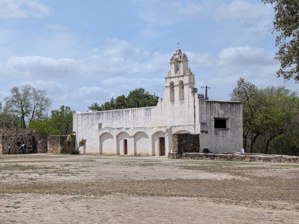
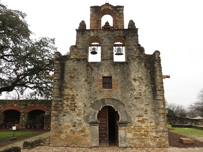
Padre Island National Seashore is one of those places. In the early 1800’s, Spain was the first to lay claim to the island, followed by Mexico, which owned the island from 1821 through 1836, at which point, the Republic of Texas claimed the land between the Nueces River and the Rio Grande. Finally, the United States wrested ownership of the island after acquiring the territory of the Republic of Texas in the mid 1800’s. Of course, the history books neglect to mention that prior to the various entities claiming ownership of the island, the indigenous people of the Karankawa were there first. The Karankawa were a nomadic group that traveled along the coastline of the barrier islands. Their traditional lands ran from Galveston Bay to the Bay of Corpus Christi. The Karankawa are first entered into the historical records in1528 when a Spanish ship wrecked on an island, near Galveston, that was inhabited by the Karankawa. Álvar Núñez Cabeza de Vaca, who was one of the shipwrecked sailors stranded on the islands, became one of the first people to provide a written history of the indigenous people and of Texas. In the mid 1700’s, there were several attempts by the Spaniards to “missionize” (code word for relocate and steal land from) the Karankawa but the fight to steal the lands lasted until the early 1800’s when military actions and smallpox decimated the population of the Karankawa. For more detailed history on the Karankawa, check out this post on the Texas State Historical Association’s website.

Padre Island has been known by many names over the years. It is currently known as Padre Island after Padre Nicolas Balli, a Spanish priest who settled there in 1804. Prior to being known as Padre Island, it was also known as La Isla Blanca (White Island) and Isla de los Malaguitas (Island of the Malaquites–a band of the Karankawa). Another interesting historical note about Padre Island is that from World War II to the1960’s, the island had a Navy bombing range on the northern tip of the island, which makes sense considering there is a naval base at nearby Corpus Christi.

Malaquite Beach Photo by M. Gonzalez
Goat’s Foot Morning Glory Photo courtesy of NPS

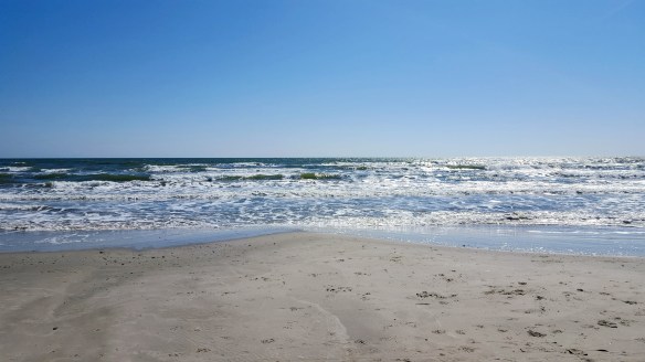
Padre Island was established as a National Park Service in 1962 and was dedicated by Lady Bird Johnson. It is one of ten national seashores under the National Park Service banner. Padre Island has the longest stretch of undeveloped barrier island in the world! Today, Padre Island National Seashore is a nature lover’s paradise! The National Seashore is home to hundreds of plants, animals, and birds. There are over 400 species of flowering plants. Padre Island and the surrounding area provides over “380 migratory, overwintering, and resident bird species (nearly half of all bird species documented in North America),” a habitat that includes prairies, dunes, tidal flats, and a hypersaline lagoon environment known as The Laguna Madre (the mother lagoon). Thirteen of these species are considered species of concern, threatened, or endangered. Birders come from all over the world to Padre Island National Seashore hoping to catch a glimpse of a rare or endangered bird.

Kemp’s ridley (Lepidochelys kempii) hatchlings making their way across the beach. Photo courtesy of NPS

And speaking of endangered, the Kemp’s ridley sea turtle, one of the most endangered sea turtle species in the world, nests on Padre Island’s shores from April to mid-July. This is one of the few places you can watch newly hatched babies get released into the wild! If you’re there between April and July, be on the lookout for red dots (reflective lollipop stakes) red flagging tape, or bright yellow flags with a turtle silhouette. This means there are turtle nests nearby and to be on the lookout! Also, if you spot a nest that hasn’t been marked, or if you see someone moving a reflector or tampering with a nest, do your part to save the turtles and report your sightings to 1-866-TURTLE5. Learn more about how you can help protect these turtles by visiting the NPS website about the Sea Turtles of Padre Island.

Padre Island National Seashore is open 24 hours a day, 365 days a year. If the entrance station is not open upon arrival, you are on the honor system and expected to pay the entrance fee on your way out. If you decide to camp there, you can go back to the station once it’s open and pay your camping fee then. The Visitor Center is open from 9a-5p every day of the year except for Thanksgiving and Christmas days. Beach accessible wheelchairs and walkers are available for use free of charge. They are available at the Visitor Center and are first come, first served.

MILE MARKER: Padre Island is the only place in Texas where 5 species of sea turtles exist:  Kemp’s ridley sea turtles, green sea turtles, loggerhead sea turtles, hawksbill sea turtles, and leatherback sea turtles. If you’re interested, check here to find out when sea turtle hatchling releases will be scheduled. People come from all over the world to watch hatchlings make their way across the beach and back into the ocean.

HIKE IT!: Grasslands Nature Trail is a .75 mile loop located near the park entrance. The trail is paved and easy to walk on. This trail allows for sweeping views of the dunes and the grasslands, as well as various wildflowers, birds, and other wildlife. Because this trail is paved, it is also wheelchair accessible. Be sure to take water with you. Use bug spray if needed and don’t feed the wildlife!

From Frontier Forts to Mountain Trails: Fort Davis National Historic Site and Davis Mountains State Park

Imagine yourself in the middle of a desert, surrounded by nothing but harsh cliffs, scrub brush, cactus, and sandy caliche. There is a dusty road stretching out from east to west and there is no sign of civilization as far as the eye can see.

Okay, this isn’t the actual road but you get the idea. (This is a road in the same general area, though.)
Photo by M. Gonzalez

This is the Chihuahuan Desert. The largest desert in North America. It stretches from northern Mexico to the southwestern US, running through southwest Texas, New Mexico, and parts of Arizona. It covers approximately 200,000 square miles and while the average elevation is only 1000 feet above sea level, elevations can range from 3,500 to 5,000 feet.

In the mid-1800’s, if you wanted to travel from San Antonio, Texas to El Paso, Texas or further onto California to join the gold rush, this was the route you had to take. It was referred to as the Trans-Pecos Trail, specifically the San Antonio-El Paso road on the Chihuahua Trail.

Park Entrance
Photo by S. Resendez

In 1854, Fort Davis was established to create a point of protection for travelers, freighters, and mail carriers. The Eighth U.S. Infantry was stationed at Fort Davis until 1891. Fort Davis, named after Secretary of War, Jefferson Davis, was instrumental in protecting, defending, and developing the western frontier. The post was situated in a box canyon in the shadow of the Davis Mountains, (known then as the Limpia Mountains). With the onset of the Civil War and the secession of Texas, Fort Davis was abandoned and stayed deserted for five years.

The original post was built quickly and was poorly constructed. After the civil war, in 1867, Fort Davis, once again, became an active post. New buildings were constructed, eventually adding a guardhouse, barracks, officer’s quarters, a temporary hospital, and storerooms. Construction went on through the 1880’s, eventually housing up to 400 soldiers.

Housing at Fort Davis
Photo by M. Gonzalez

Commanches and Apaches continued to make the road hazardous travel for mail carriers and travelers, so soldiers spent the majority of their time patrolling the road and fighting off the Apache, as the Commanche had been defeated years earlier. The Apache, led by their leader, Victorio, were pushed into Mexico where, after eluding US troops for over a decade, they were finally captured and killed.

In June of 1891, Fort Davis was ordered to shut down and was abandoned, having outlived its usefulness. In 1961, the fort was authorized as a national historic site, a unit of the National Park Service.

Before we travel onto the Davis Mountains State Park, we would be remiss if we didn’t delve a tiny bit into what an integral part the Buffalo Soldiers played in the formation, maintenance, and safety of Fort Davis and the San Antonio-El Paso Road.

Following the Civil War, as Fort Davis was recommissioned, Troops from the Ninth U.S. Cavalry, the Buffalo Soldiers, were the first to report. They helped to reconstruct the fort, faced down conflicts with the Apache and the Comanche, and protected the mail, as well as travelers, on the San Antonio-El Paso road. The Buffalo Soldiers were integral in the day to day functions of Fort Davis. In addition to providing protection to travelers and escorting freight and mail, they repaired military telegraph lines and guarded water holes.

Even though the civil war was over, the Buffalo Soldiers still faced discrimination. Troops were segregated and rations and equipment were given to the white troops first, with the black troops receiving whatever was leftover. Despite all this, the Buffalo soldiers proved to be a force for keeping West Texas in check. They became known as the peacekeepers of the area and were highly revered by the Native Americans for their fierce fighting skills. It was the Native Americans who nicknamed these regiments, “Buffalo Soldiers”. The African-American soldiers accepted the name and adopted the Buffalo as a symbol of honor.

On a side note, in addition to keeping the peace in West Texas, active units of the Buffalo Soldiers served from 1866 until 1952. While remaining segregated, the Buffalo Soldiers served and fought in the Spanish-American War, protected the U.S. during the Mexican Revolution, World War I and World War II, as well as the Korean War.

Now, let’s make our way to the Davis Mountains State Park. It’s about a 10 minute drive from Fort Davis. Once you’re on the grounds, you will find yourself in an expansive state park of approximately 2,700 acres that reaches elevations of up to 6,000 feet! It may not seem like it, but this park is busy, especially beginning in the spring to the late summer. Camping is available but reservations are suggested, for camping AND day use, especially during their busy season.

Pullout view from Skyline Drive
Photo by M. Gonzalez

There are many things to see and do at Davis Mountains State Park. You can go camping, hiking, backpacking, mountain biking, and if you have one, you can bring your horse and hit the trails! There’s a scenic drive that winds its way up the mountains for some spectacular views. If you’re there at night, or almost anywhere in this general area, star gazing is at its best. (The McDonald Observatory is nearby so you could book a star party with some friends if you really want to take advantage of the dark sky!)

In addition to all of the nature and the views, there are a couple of shops available, the smaller shop being at the park entrance office and the larger shop located at the Indian Lodge which is further into the park.

Indian Lodge in Davis Mountains State Park Photo courtesy Texas Parks and Wildlife Department © 2006

If you plan on spending several days in and around this area of west Texas, why not check to see if there are any rooms available at the The Indian Lodge? The Lodge has been recently renovated and would be a wonderful place to stay while you explore the area.

As you make your way to the top of Skyline Drive, take a minute to stop at the Interpretive Center. This short stop is worth your time if you have any interest in the park’s wildlife, geology, or history. And if you’re a birder, you’re really going to love stopping here because they have an indoor bird blind which allows you to sit in air conditioned comfort while you watch the birds fly in and out. There are also has GPS Units available for loan if you plan on hiking in the park. Please say hi to Charlie if you go by the Interpretive Center. He’s a wealth of information!

The top of Skyline Drive Photo by M. Gonzalez

After your stop, continue towards the top of Skyline Drive, where you can park and take in the expansive views.

There is so much more to write about this park and its history but it’s just too much to cover. Take some time to visit their website. It’s got a wealth of information about everything the park has to offer. It also has alerts about things you may need to be aware of as you plan your trip. Make sure you check the website!

MILE MARKER: Cathay Williams was the first documented female buffalo soldier! She served from 1866-68. Since women were not allowed to serve then, Williams disguised herself as a man to enlist in the army. Read more about her history and more about the Buffalo Soldiers at the Bexar County Buffalo Soldiers Association.

HIKE IT!: There are several trails to choose from if you decide to hike while at Davis Mountains State Park. Check the website for details on length and difficulty. If you’re planning a visit to the Fort Davis National Historic Site, there’s a hiking path that connects both parks. It would be our recommendation, if you’re a less experienced hiker, especially if you’re hiking in higher elevations than you may be used to, that you study the details of this hike and make your decision based on your experience. While it is a relatively short hike (approximately 1 mile), you will be encountering an elevation drop on your way to Fort Davis and an elevation gain back to where you parked at the Davis Mountain State Park.

Remember, you’re in the mountains!! Most of these trails will incur elevation drops and elevation gains. You’re also in a desert, so hike wisely. Start your hikes early in the morning and take more water than you think you may need. Borrow a GPS unit from the Interpretive Center if it makes you feel more confident. Click here for an interactive map of the Davis Mountains State Park Trails. Be safe and have fun!

Rocky Mountain National Park: Trails, Wildlife, and Majestic Views

“The mountains are calling and I must go.” – John Muir 

11,000 years ago, humans began to venture into the untamed wilderness we now know as Rocky Mountain National Park. Replete with an abundance of wild animals, flora, fauna, and glacier-sculpted mountains, the Ute came to settle in the meadows and the valleys, eventually moving on in the 1700’s. With the Louisiana Purchase of 1803, the United States acquired the land that we know now as the Rocky Mountain National Park. In the late 1850’s, the gold rush in and around Pike’s Peak brought prospectors to the area. Hunters and trappers also began to discover the abundance of wildlife in the rugged area and despite the harsh winters, ranchers, hunters, miners, and homesteaders began to settle.

As tourism built, a conservation movement was already underway. Now renowned naturalists, John Muir, Gifford Pinchot, and Teddy Roosevelt, were instrumental in establishing the Estes Park Protective and Improvement Association. Enos Mills, a naturalist and nature guide began promoting, in earnest, the creation of a national park. After years of exhaustive lobbying, lecturing, and letter writing by Mr. Mills, President Woodrow Wilson signed the Rocky Mountain National Park Act in 1915, despite opposition from miners and loggers in the area.

During the depression of the 1930’s, the CCC (Civilian Conservation Corp) helped the National Park Service to build Trail Ridge Road. This was an integral part of the park because unlike other national parks at that time, there was no rail service to take tourists to the park. Rocky Mountain National Park was primarily an “auto park”. This meant that roads were a necessity for tourists to be able to experience all the beauty the park had to offer.

Rocky Mountain National Park hosts approximately 4 million visitors a year, with a record high of 4.7 million back in 2020.

There are 3 main entrances: 

Grand Lake Entrance if you wish to go clockwise on Trail Ridge Road.  

Beaver Meadows The entrance to get you to Bear Lake and you can also reach Trail Ridge Rd. 

Fall River Entrance if you wish to go counter-clockwise on Trail Ridge Road and a good place to see bighorn sheep.

As of the date this post was written, timed entry reservations are not needed in the spring and fall seasons. After May 23rd, you MUST make a timed entry reservation and if you wish to include a visit to Bear Lake, that must be stipulated with your timed entry reservation. Make sure you go to the Rocky Mountain National Park website and check out the Plan Your Visit section. Always make sure you’re looking ahead and planning your trip. Entrance fees can vary with your age and passes can be purchased ahead of time. Cash is NOT accepted so plan to use your credit card. There are fee-free entrance days but if you choose to go on those days, be aware that the park entrances may have extra long lines for entry. Everything you need to know is on the website so decide what time of year you’d like to visit, plan ahead, then go! If you live in and around the Rocky Mountain National Park and visit often, you might consider purchasing a transponder for your vehicle. Transponders are for park visitors who visit the park frequently, especially before 9a and after 2p, outside of the timed entry window. Check the park information page for more information about transponders.

There are approximately 355 miles of hiking trails throughout the park. Some good, simple hikes to do – especially when you are coming up to this altitude and need to take it easy.

  • Sprague Lake .7 miles (loop) 
  • Bear Lake .7 miles (loop) 
  • Alberta Falls 1.6 miles (in and out) 

There are also many more moderate, difficult, and longer trails, too.  Be sure to check out the Park newspaper for all the trail information and always check with the rangers on trail conditions before you head out, especially if you’re hiking in the spring and the fall, when weather can quickly take a turn.

If you’re not interested in hiking and just want to bask in the glory of the beautiful Rocky Mountains, take the Trail Ridge Road up to Alpine Ridge and the Alpine Visitor Center. Did you know that Rocky Mountain National Park has many aspects of the boreal forest?  While not in the continuous range of the geographic boreal forest, scientists have noted that many trees and animals in the Rocky Mountain National Park are the same as what you would find in the boreal forest that stretches from Alaska to New Foundland, and through Russia.

Feeling a little adventurous? While Trail Ridge Road is the highest, continuous, paved road in the nation, the Old Fall River Road is a scenic road that reminds you to slow down and enjoy the scenery. Old Fall River Road is an 11 mile long, one-way, gravel road. The speed limit is 15 mph and will take you, approximately, one hour to complete. There are several switchbacks and if driving up a road with no guardrails makes you antsy, this road may not be for you. But it is a one-way road so you will not encounter opposing traffic. Most of the people who take this road are driving it because they’re in no hurry. There are wider spots for you to pull over if someone does want to pass you. If you have the time, I would suggest taking Old Fall River Road up to Alpine Ridge and taking the Trail Ridge Road back down. Adventure awaits!

Rocky Mountain National Park is open year round, 24 hours a day, 365 days a year. It is located at 1000 US Hwy 36
Estes Park, CO 80517

The Information Office is open year-round: 8:00 a.m. – 4:00 p.m. daily in summer; 8:00 a.m. – 4:00 p.m. Mondays – Fridays and 8:00 a.m. – 12:00 p.m. Saturdays – Sundays in winter. Recorded Trail Ridge Road status: (970) 586-1222.

Information on accessible trails can be found here and all-terrain wheelchairs can be reserved at no cost to you.  Just call the Estes Park Mountain Shop at 970-586-6548.

MILE MARKER: There were so many women trailblazers that contributed to the development and conservation of this park, they could have a blog post of their own. Homesteaders, authors, teachers, and conservationists, these women were an integral part of making Rocky Mountain National Park the jewel it is today. To read more about them, go here to the history of the park and learn more about these female trailblazers!


“Canyon de Chelly: Where Culture, History, and Landscape Meet”

Canyon de Chelly was authorized in 1931, but its roots go back further than our imaginations can carry us.

Initially inhabited by Ancient Puebloans until the mid-1300’s, they were followed by the Hopi, and in the mid-1600’s, the lands were finally settled by the Navajo, also known as the Diné.

The Navajo were able to prosper in the canyons, raising their families, farming crops, planting orchards, and caring for livestock, until the late 1700’s when many external forces created challenges to their ability to live on their rightful land. Invasions by the Ute, other tribes, and Spanish colonists challenged Navajo defenses, which were eventually overrun.

The Navajo built their lands up again, only to be assailed in the 1860’s by Col. Kit Carson of the U.S. Army, who utilized a scorched earth policy to decimate the land and forced the Navajo people to leave their home and walk 300+ miles over a span of 3 years. The Navajo, as well as the Mescalero Apache, were forcibly removed from their homelands and “relocated” to an outpost known as the Bosque Redondo Indian Reservation, which was intended to be a reservation but quickly became a prison camp. Lack of rations, disease, and horrific living conditions resulted in the deaths of approximately 1500 people, not including those who perished during the Long Walk to Bosque Redondo.

In 1868, a treaty was signed acknowledging the sovereignty of the Navajo Nation and the Navajo people were allowed to return to their land. In 1931, President Herbert Hoover authorized the Canyon de Chelly National Monument. Canyon de Chelly covers approximately 84,000 acres, all of which resides fully in the Navajo Nation. There are still at least 40 families residing within the boundaries of the park. The Navajo people and the National Park system share resources and work in tandem to preserve this beautiful monument.

Canyon de Chelly has no entrance fee! There is a Welcome Center with a park store. The entrance gates are open from 8a-5p daily except for Thanksgiving, Christmas and New Year’s Day.

Plan ahead to learn more about the scenic drives. There are two paved, rim drives with several overlooks. The North Rim Overlook offers views of the cliffside dwellings and the South Rim offers more scenic views including a view of Spider Rock.

Each drive takes approximately 2 hours, according to the park website, so plan for a 2-4 hour trip if you plan on making all stops for photo opportunities. The park website provides suggestions for what to see depending on how much time you’ve allotted for your visit.

Primitive campsites are available for a fee. Self-guided hikes and Ranger led programs are available but check before hand for changes in fees and schedules. Private canyon tours are available by hiking, horseback or vehicle. As with other parks and sites where people are currently in residence, please look out for and respect any signs that prohibit taking photographs.

MILE MARKER: The Navajo and Apache people are Athabaskan speakers. They are distantly related to the Athabaskan people from Canada and Alaska.

HIKE IT!: The White House Ruins Trail is a 2.5 mile, round trip hike that descends 600 feet into the canyon. This is the only self-guided tour at Canyon de Chelly and although it is currently closed, there are plans to reopen the trail sometime in 2025.

Check ahead on the website before making plans.

El Camino de San Antonio Missions: How San Antonio Became Part of a Legendary Pilgrimage

Last week, we shared our visit to The World Heritage Center and introduced you to the Mission Trail. This is a Hike & Bike Trail that connects all the San Antonio Missions. This trail is an out and back trail that is approximately 14 miles long. After we finished up there, we made our way to the Padre Margil Pilgrimage Center.

Before we talk a little bit about the Pilgrimage Center, it is worth the time to learn about, and possibly introduce you to The Camino de Santiago, also known as The Way of St. James. The Camino is a pilgrimage that starts from various places, all over England and Europe, but every route leads the pilgrim to their final destination, the Church of St. James.

Until 2018, when the Camino de San Antonio Missions became a recognized part of El Camino de Santiago, there were no other formally recognized routes to the Camino outside of Europe. It is a great honor for San Antonio Missions to be formally recognized as part of the Camino!

The Way of St. James, has many starting points and these starting points are reflective of the route the Pilgrim takes as they make their way to their final destination. For example, the Camino Frances, or The French Way, which is the most common route, begins at the base of the Pyrenees Mountains in France and traverses across the northern part of Spain towards St. James. The Camino Portugués, or The Portuguese Way, begins in the southern part of Portugal and makes its way north to the church of St. James. And, The Camino Ingles, or the English Way, begins from one of two traditional starting points, either Ferrol or Coruña, and makes its way south to St. James Church. The English Way is named the English Way (even though both starting points are in Spain) for Pilgrims who began their pilgrimage in England and Ireland.

In order for your journey to count towards accreditation, you are required to have travelled at least the last 100 km on foot (or the last 200 km by bicycle), which is demonstrated by the “Credencial del Peregrino” which you have had stamped along the route travelled. The Credencial or Credential, is a sort of “passport” you receive upon starting your pilgrimage. While traveling along The Way, there are places known as albergas that are available for Pilgrims to spend the night as they journey towards St. James. Upon arrival at an alberga, you present your Credencial and receive a stamp to acknowledge that you stayed there on your way to St. James. At the end of your journey, you submit your Credencial as proof of your Pilgrimage and receive a Compostela, or accreditation, at the culmination of your journey.

El Camino de San Antonio Missions is a way to link your journey on the Camino de Santiago. Travel by foot on the Camino de San Antonio, traveling to all four Missions and the San Fernando Cathedral. Completing this journey counts as 30 km towards the Camino Ingles in Spain. Continue your Camino in Spain beginning in Ferrol and complete the remaining 70 km to complete the required 100 km towards your Compostela. From the official website: “If a pilgrim has already started a route on foot outside Spain along one of the routes recognized by the International Pilgrim’s Reception Office system, the required distance in Spain shall be no less than 70 kilometers.” Get more detailed information about the Pilgrimage and all the available routes at website of El Camino de Santiago.

For more details on the San Antonio portion of the Pilgrimage, visit the website for El Camino de San Antonio.

The Pilgrimage Center is a bright and welcoming, place with a small shop and a small cafe. There’s nothing fancy in the cafe but it’s a good place to grab a drink and a snack if you’ve been walking. There are tables outside in some shady areas to sit and relax for a bit. There’s not really a museum, per se, but there are some touch screens with some interesting information about a variety of subjects, including the Camino de San Antonio, the Camino de Santiago, the Riverwalk, and other areas of interest. There is also a display entitled “Hands in Prayer” showcasing the meaning and use of strings of beads from different religions.  There are places where children can do a “craft” of sorts creating ropes of beads. The building is a welcome place to sit and refresh on a hot day. The shop has some nice items in it. Buying a small souvenir helps to support the center so it’s all for a good cause. This is also where you will buy your Pilgrim Passport. For $10 you get your passport and a keychain. The fully stamped passport is what you will need to receive your Compostela upon completion.

The Padre Margil Pilgrimage Center is located at 263 Felisa St., behind Mission Concepción. It’s open M-Sa from 9a-5p.

MILE MARKER: Compostela means Field of Stars. It comes from the Latin “campus stellae” and is based on the stars of the Milky Way that, according to legend since the Middle Ages, had been outlined by the apostle St. James and followed by pilgrims to reach his tomb.

HIKE IT!: The Camino de San Antonio Missions is approximately 19-20 miles. The route does not have to be completed in one day and can be completed in sections. The route can be completed from north to south, or south to north. If you think you may ever travel to Spain to complete your Camino, register on the San Antonio website for your Compostela. Don’t forget, summer months can be brutally hot, so remember to bring plenty of water and sunscreen. See our downloadable checklist for ideas on what to bring for a city hike.

The San Antonio Missions National Historic Park and The World Heritage Center: A Complete Guide

On July 5, 2015, the five San Antonio Missions were designated the first UNESCO World Heritage site in Texas. The San Antonio Missions National Historical Park ensures that these treasures are preserved for future generations. Through guided tours, museum exhibits, and cultural events, the stories of the missions come alive, inviting visitors to reflect on the enduring legacies of cooperation, adaptation, and perseverance.

The San Antonio Missions tell the stories of the people who came into the Spanish missions to live in the 1700s. Acculturating and converting the Indigenous population in order to become Spanish citizens reverberates today in the southwest United States. Our history is part of who we were, who we are, and who we will be. The National Park Service invites you to discover American history in all its diversity at San Antonio Missions National Historical Park.

Other mission sites, such as those in Goliad and Nacogdoches, are maintained by state parks and local organizations, each contributing to the preservation of Texas’ rich history. Efforts to document and restore these sites ensure that the diverse narratives they hold are not lost to time.

The City of San Antonio World Heritage Office manages the World Heritage Center, Mission Marquee Plaza, and the Spanish Governor’s Palace. On February 7, 2025, the World Heritage Center opened its doors to the public. Set on the site of the former Mission San José farmland, The Center is a doorway, not only to the San Antonio Missions, but to the neighborhoods surrounding them. The Center provides visitor orientation, informs the community about the World Heritage Designation, and honors the legacies of the people connected to our World Heritage missions, in particular our mission descendants.

Upon arriving at The Center, the first thing you might notice, and truly appreciate (especially if you’re from San Antonio) are the grounds. The Center is set on the site of the former historic Mission San Jose farmland and the former Mission Drive-In Theater. They have retained the original facade of the old Mission Drive-In Theater. There is a large, grassy field in front of one of the old screens and the old concession stand is still there. The area is now referred to as Mission Plaza and also includes a public library and YMCA.

Mission Marquee Plaza, formerly known as the Mission Drive-In Theatre is open to the public and hosts a variety of free City of San Antonio events and various programs throughout the year.:

  • Farmers & Artisans Market: Every 1st & 3rd Saturday (March- Nov.)
  • Movie Nights: Every 1st and 3rd Saturday (May-Nov.) — Movies begin at dusk
  • Throwback Thursday Movie Nights: Every 3rd Thursday (May-Nov.)

For more details and information about Mission Marquee Plaza, please check their website.

World Heritage Center Veranda Photo by M. Gonzalez

Moving to The Center, there are beautiful, large, glass windows and an ornate, scrolling metal wall, also referred to as The Veranda. The Veranda was designed by local artist Adriana Garcia, and is also a Tricentennial Celebration Commission’s Legacy Gift to the citizens of San Antonio. The Plaza is easy to find with the San Jose Mission’s silhouette in the background.

The Center is a small museum with with interactive video boards, interpretive displays, and life-sized displays of regalia. It has enough information to keep visitors interested for at least 30 minutes or longer. Children might have some interest but there’s probably not enough there to keep a young child engaged. There are publications available to all visitors, most collectible is a very nice brochure highlighting the San Antonio River Walk. There is also a brochure featuring World Heritage Sites in the US. They will also, eventually, have a small gift shop.

Whether you’re a history enthusiast, a nature lover, or simply seeking a connection to the past, the Spanish Missions of San Antonio, Texas offer an unparalleled journey. Walk through the arched corridors, listen to the whispers of history in the mission chapels, and let the spirit of this remarkable heritage inspire you. Here, the past is not just remembered but celebrated, a testament to the resilience and creativity of those who came before.

Visit the San Antonio Missions! Choose one or make a full day of it.

The Alamo: The most recognizable of all the San Antonio Missions is The Alamo. Originally referred to as Mission San Antonio de Valero, the most recognizable part of the building was the chapel. The grounds continue to develop and grow as more and more history is discovered and as new information is brought to light.

Mission Concepcion: Mission Concepcion is considered to be the oldest, unrestored church in the United States. It is an active Catholic Church serving as a parish within the Archdiocese of San Antonio. There are several frescos still visible on the walls of the church, including the famous “Eye of God”. Mission Concepcion grounds also house the Padre Margill Pilgrimage Center.

Mission San Juan: Mission San Juan de Capistrano was originally founded in East Texas and moved to San Antonio in 1731. There is a short trail behind the mission, the Yanaguana Trail, that leads to the San Antonio river.

Mission Espada: Mission Espada is an active parish, meaning it still functions as a Catholic church. It is the oldest of all the San Antonio Missions and the first Mission to be founded in Texas in 1690. It was relocated from the Houston area in 1731.

The World Heritage Center is located at 3106 Roosevelt Ave., 78214. They are open from 10a to 5p on Tuesdays, Wednesdays, & Fridays. They are open from 10a to 8p on Thursdays, and from 10a to 5p on Saturdays & Sundays. They are closed on Mondays.


The San Antonio Missions National Historical Park is open daily from 9 AM–5 PM, except on Thanksgiving, Christmas, and New Year’s Day. The park’s outdoor grounds are open from sunrise to sunset. 

MILE MARKER: In 2024, Mission San José along with 18 other sites in 10 states have been added to the National Underground Railroad Network to Freedom today which recognizes places and programs with verifiable connections to the Underground Railroad and the resistance to enslavement through escape and flight.