West Texas Gems: Balmorhea and the Chihuahuan Desert Nature Center

There are signs that in around 1849, Mescalero Apache watered their horses at the Mescalero Springs. Later, Mexican farmers dug canals by hand to irrigate their crops, which they later sold to people who lived in Fort Davis. The farmers called these springs the San Solomon Springs. In 1927, the springs were dredged and a canal was built to better utilize the flow of the water. Records show that the springs around Balmorhea have been in use for almost 11,000 years.

San Solomon Springs Motor Courts
Photo by S. Resendez

In 1934, the State Board of Texas acquired approximately 46 acres around the San Solomon Springs. The Civilian Conservation Corp (CCC) arrived at the springs in July 1934 and began work on building what would later become Balmorhea State Park. The CCC created the 1.3 acre pool around the springs. They also built the concession building, the bath houses, and the motel court using native limestone and hand hewn adobe bricks.

Balmorhea Swimming Pool Photo by S. Resendez

The San Solomon Springs is the largest in a series of 6 springs located in the Chihuahuan desert. The Balmorhea State Park Swimming Pool is the world’s largest spring-fed pool and often referred to as the crown jewel of the Texas State Parks System. The springs originally emptied into what is known as a ciénga or desert wetland. Construction of the swimming pool, back in 1934, resulted in the destruction of the natural springs which were rebuilt and fashioned into two man-made ciéngas.

Ciénega Photo by M. Gonzalez

There is an overlook by the RV section of the park for visitors to look for wildlife like deer, javelina, squirrels, turtles, lizards and dragonflies, which also utilize the springs. San Solomon Springs also serves as a stop for resident and migratory birds and is home to several rare and endangered species of snails and fish. San Solomon Springs is the largest spring in the Balmorhea area, and the habitat at Balmorhea State Park is very important for the con­ser­vation of these species.

Balmorhea State Park is located at 9207 TX-17, Toyahvale, TX 79786. Daily entrance fee for adults is $7 and free for children 12 and under. Park hours are from 8a to 7:30p or sunset (whichever comes first) and office hours are from 8a-5p. They often reach capacity and highly recommend reservations for both camping and day use. You can reserve passes online or by calling the customer service center before you visit. Check the park’s Facebook page for updates. Read their FAQ page for more detailed information about park and pool rules. Make sure you plan your visit before going!

Chihuahuan Desert Nature Center Entrance
Photo by S. Resendez

About 41 miles south and just outside of Fort Davis, Texas, sits the Chihuahuan Desert Nature Center. The Chihuahuan Desert Research Institute (CDRI) is a nonprofit organization that was established in 1973 and housed in Alpine, Texas. Its principal founders were science professors at Sul Ross State University, a university that the institute continues to work closely with today. Today, the CDRI is the Chihuahuan Desert Nature Center and is located on 507 acres in the foothills of the Davis Mountains.

Susan intently studying the locations of the mines! Photo by M. Gonzalez

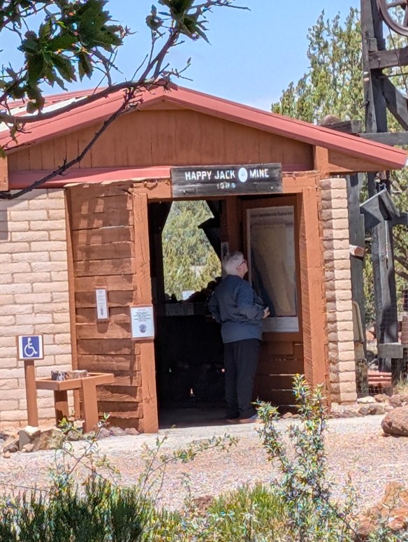
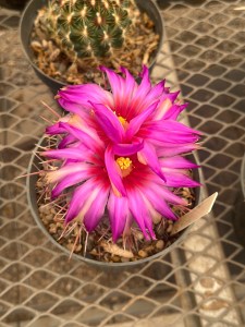
The Nature Center is open year round. If you’re interested in exhibits about geology, history, and culture of the Chihuahuan desert, there is a mining exhibit detailing desert mining and the geological changes that have occurred in the Trans-Pecos of Texas over the last 2 billion years! A bird blind is available for birders, and there’s a cactus museum which houses over 200 species, sub-species, and varieties of cacti and succulents.

If you don’t feel like hiking, there are botanical gardens which encompass a wildscape garden, a self-guided stroll through a Trans Pecos Natives garden, a pollinator garden trail, and a native grasses exhibit.

Check the website for Chihuahuan Desert Nature Center before heading out. The Center is located off of Hwy 118, 4 miles SE of Fort Davis at 43869 St. Hwy. 118, Their hours are Monday-Saturday, 9a-5p.

MILE MARKER: Would you believe that cactus can be found as far north as Canada?! Some species have evolved to withstand cold temperatures and dry conditions. Southern prairies and certain regions by the Great Lakes, provide habitats with enough sun, well-drained soil, and suitable temperatures for cacti to thrive.

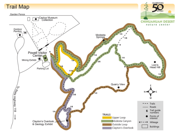
HIKE IT!: There are lots of great hiking trails at the Chihuahuan Desert Nature Center. There are 5 trails ranging from .25 mile (scenic loop inside the botanical garden) to a 2.5 mile loop, which is considered a strenuous hike. Remember, you are hiking at an elevation of approximately 5,000 feet! Consider the weather and your own physical abilities. While the trails are mostly earthen, they may be uneven so take your hiking sticks, sunscreen, a good hat to cover your head and face, and plenty of water. After all, you’re desert hiking!

Trail Map for CDNC Photo courtesy of Chihuahuan Desert Nature Center

Why Padre Island National Seashore Should be on Your Bucket List

Last week, we talked about places where history seems to be standing still. There are places in our country that inhabit their physical surroundings, virtually unchanged for hundreds, if not thousands, of years.

Padre Island National Seashore is one of those places. In the early 1800’s, Spain was the first to lay claim to the island, followed by Mexico, which owned the island from 1821 through 1836, at which point, the Republic of Texas claimed the land between the Nueces River and the Rio Grande. Finally, the United States wrested ownership of the island after acquiring the territory of the Republic of Texas in the mid 1800’s. Of course, the history books neglect to mention that prior to the various entities claiming ownership of the island, the indigenous people of the Karankawa were there first. The Karankawa were a nomadic group that traveled along the coastline of the barrier islands. Their traditional lands ran from Galveston Bay to the Bay of Corpus Christi. The Karankawa are first entered into the historical records in1528 when a Spanish ship wrecked on an island, near Galveston, that was inhabited by the Karankawa. Álvar Núñez Cabeza de Vaca, who was one of the shipwrecked sailors stranded on the islands, became one of the first people to provide a written history of the indigenous people and of Texas. In the mid 1700’s, there were several attempts by the Spaniards to “missionize” (code word for relocate and steal land from) the Karankawa but the fight to steal the lands lasted until the early 1800’s when military actions and smallpox decimated the population of the Karankawa. For more detailed history on the Karankawa, check out this post on the Texas State Historical Association’s website.

Padre Island has been known by many names over the years. It is currently known as Padre Island after Padre Nicolas Balli, a Spanish priest who settled there in 1804. Prior to being known as Padre Island, it was also known as La Isla Blanca (White Island) and Isla de los Malaguitas (Island of the Malaquites–a band of the Karankawa). Another interesting historical note about Padre Island is that from World War II to the1960’s, the island had a Navy bombing range on the northern tip of the island, which makes sense considering there is a naval base at nearby Corpus Christi.

Malaquite Beach Photo by M. Gonzalez
Goat’s Foot Morning Glory Photo courtesy of NPS

Padre Island was established as a National Park Service in 1962 and was dedicated by Lady Bird Johnson. It is one of ten national seashores under the National Park Service banner. Padre Island has the longest stretch of undeveloped barrier island in the world! Today, Padre Island National Seashore is a nature lover’s paradise! The National Seashore is home to hundreds of plants, animals, and birds. There are over 400 species of flowering plants. Padre Island and the surrounding area provides over “380 migratory, overwintering, and resident bird species (nearly half of all bird species documented in North America),” a habitat that includes prairies, dunes, tidal flats, and a hypersaline lagoon environment known as The Laguna Madre (the mother lagoon). Thirteen of these species are considered species of concern, threatened, or endangered. Birders come from all over the world to Padre Island National Seashore hoping to catch a glimpse of a rare or endangered bird.

Kemp’s ridley (Lepidochelys kempii) hatchlings making their way across the beach. Photo courtesy of NPS

And speaking of endangered, the Kemp’s ridley sea turtle, one of the most endangered sea turtle species in the world, nests on Padre Island’s shores from April to mid-July. This is one of the few places you can watch newly hatched babies get released into the wild! If you’re there between April and July, be on the lookout for red dots (reflective lollipop stakes) red flagging tape, or bright yellow flags with a turtle silhouette. This means there are turtle nests nearby and to be on the lookout! Also, if you spot a nest that hasn’t been marked, or if you see someone moving a reflector or tampering with a nest, do your part to save the turtles and report your sightings to 1-866-TURTLE5. Learn more about how you can help protect these turtles by visiting the NPS website about the Sea Turtles of Padre Island.

Padre Island National Seashore is open 24 hours a day, 365 days a year. If the entrance station is not open upon arrival, you are on the honor system and expected to pay the entrance fee on your way out. If you decide to camp there, you can go back to the station once it’s open and pay your camping fee then. The Visitor Center is open from 9a-5p every day of the year except for Thanksgiving and Christmas days. Beach accessible wheelchairs and walkers are available for use free of charge. They are available at the Visitor Center and are first come, first served.

MILE MARKER: Padre Island is the only place in Texas where 5 species of sea turtles exist:  Kemp’s ridley sea turtles, green sea turtles, loggerhead sea turtles, hawksbill sea turtles, and leatherback sea turtles. If you’re interested, check here to find out when sea turtle hatchling releases will be scheduled. People come from all over the world to watch hatchlings make their way across the beach and back into the ocean.

HIKE IT!: Grasslands Nature Trail is a .75 mile loop located near the park entrance. The trail is paved and easy to walk on. This trail allows for sweeping views of the dunes and the grasslands, as well as various wildflowers, birds, and other wildlife. Because this trail is paved, it is also wheelchair accessible. Be sure to take water with you. Use bug spray if needed and don’t feed the wildlife!