On our podcast, we’ve talked before about how the average person can make a difference in how our lands are cared for and conserved. You traveled with us to the Chihuahuan Desert Nature Center and saw how research, education, and conservation work cohesively. Now, let’s visit another beautiful area off Cibolo Creek in Boerne, Texas, that shows what a handful of people and a small city can do when they work together to preserve and conserve.
Photo by S. Resendez
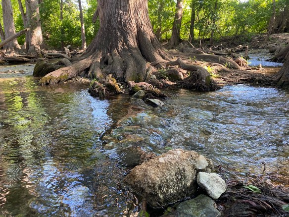
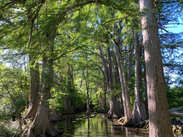
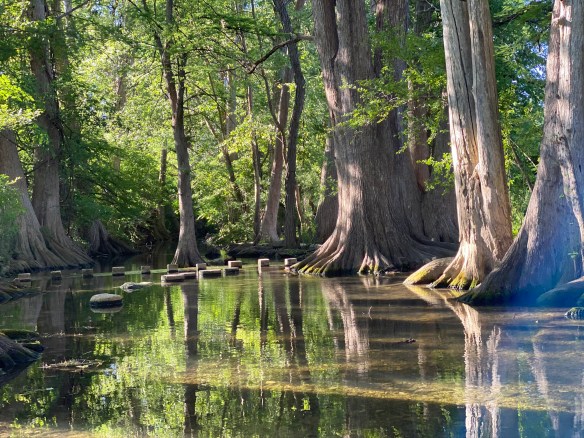
In 1988, Carolyn Chipman Evans, her husband, Brent Evans, along with several friends, began advocating to restore and conserve a segment of Cibolo Creek. Gaining the support of the city of Boerne, the group brought the need for the conservation of their part of Cibolo Creek to the public and began a movement to create what eventually became the Cibolo Center for Conservation. With the purchase of the neighboring Herff Farm in 2007, and the creation of the Nest Nature School, the Center offers the local and surrounding community the opportunity to educate, hike, and garden. The Center provides a space for special events and exhibits, as well as a weekly farmer’s market. They serve more than 70,000 children, adults, and families a year.
Photo by S. Resendez
Cibolo Center for Conservation offers a plethora of outdoor learning programs for children, as well as opportunities for 18+ interns, educators, and adult education workshops for adults. Read all about it here.
Whether you’re visiting for the scenery, the wildlife, or a quiet escape into nature, Cibolo Creek Nature Center is a place that invites you to slow down and discover something new. Cibolo Creek Nature Center is located at 140 City Park Rd, Boerne, TX. Their visitor center hours are M–F from 9 am to 4:30 pm and the trail hours are from 8am to dusk, 7 days a week.
Photo by S. Resendez
MILE MARKER: Many visitors don’t realize that Cibolo Creek Nature Center is more than just a beautiful place, it’s a site rich with history and biodiversity. Archaeologists have found evidence of human life here dating back over 10,000 years, and the preserve protects four distinct ecosystems within just a few miles of trail. From the shady creekside to the open prairie, every step offers a glimpse into the natural and cultural story of the Texas Hill Country.
HIKE IT!: The main trail in the park is the Prairie, Creekside, and Woodlands Trail Loop. There is a map at the center that shows how each section of the hike traverses through distinct ecological areas. There are several other trails and many of them can be combined to create a longer hiking experience if that’s what you’re seeking.
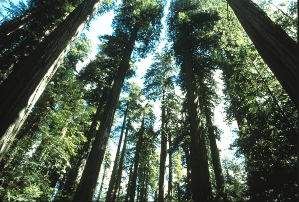
When people think of the Redwood National Forest, the first thing that comes to mind is the trees. Redwood National Forest is home to some of the tallest trees on earth, but the landscapes in and around the forest consist of more than just giant trees. Oak woodlands, rivers, prairies, and coastline make up the surrounding landscape. But we get it; you go for the trees. We all go for the trees…but there’s so much more!
Redwood National and State Parks is unique because the National Park Service (federal) and California State Parks (state) jointly manage the parks. Approximately 55% of the park is under federal management: the federal government, through the National Park Service (NPS), owns and manages a portion of the parkland, which was initially designated as Redwood National Park in 1968. The remaining 45% of the park is managed by the state of California, through California State Parks. California owns and manages the land in three separate state parks that are part of the larger, cooperatively managed unit: Del Norte Coast Redwoods State Park, Jedediah Smith Redwoods State Park, and Prairie Creek Redwoods State Park. In 1994, the NPS and California State Parks formed a cooperative management agreement to manage the parks as a single unit, maximizing resource protection.
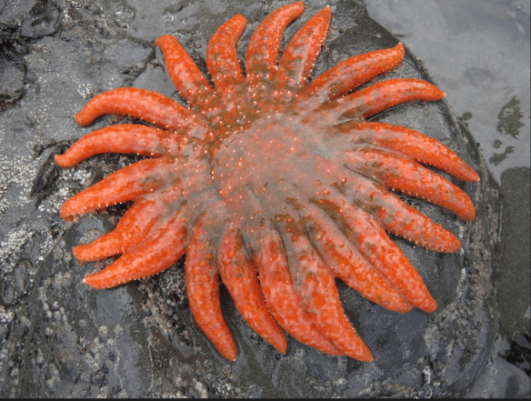
Sea Star on Rock
Photo courtesy of NPS
The abundance of ecological diversity in the Redwood Forest led to it being designated a UNESCO World Heritage Site in 1980. The diverse species of animals range from birds, land mammals, marine mammals, fish, and tide pool creatures such as sea stars and sea anemones. The Redwood Forest is also home to several threatened and endangered species such as the Northern Spotted Owl and the Steller Sea Lion. Redwood National and State Parks work hard to preserve, monitor, and safeguard fish and wildlife habitats to support recovery.
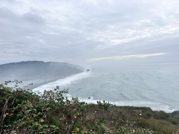
Redwood National Park is a total of 139,000 acres, or about 217 square miles, when combined with the three state parks (Jedediah Smith, Del Norte Coast, and Prairie Creek). Without the state parks, the national park itself is 131,983 acres, or 206 square miles, which includes about 40,000 acres of old-growth forest. The entire park extends for 35-60 miles along the northern California coastline.
Redwood National Forest Coastline
Photo by S. Resendez
The Redwood National and State Park(s) is open year round but the Visitor’s Centers operate on a seasonal schedule. Check the website for information on hours and times. Cell service is limited and while GPS works, it often offers confusing directions. plan ahead by:
Carrying a physical map, especially if venturing into remote areas.
Using official park maps, available at visitor centers and on the park’s website.
Using road signs within the park rather than GPS apps, which may misdirect you.
It’s also a good idea to check conditions before heading out because heavy fog might prevent you from seeing some of the sights you’re planning to visit. Luckily, the NPS site has a page made just to let you know what current conditions are at the park at all times. Check that page right before you head out for alerts, road closures, and trail information.
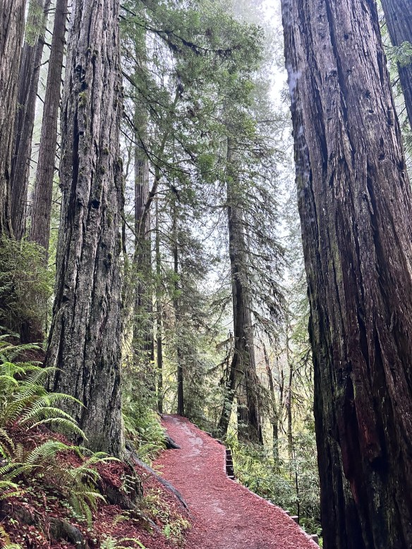
MILE MARKER: Did you know the redwoods in California’s Redwood National and State Parks are not just the tallest trees on Earth — they’re weather-makers too? These ancient giants capture fog from the Pacific, absorbing moisture through their needles and creating their own microclimate. It’s a self-sustaining forest, where the trees literally drink from the clouds.
Hiking Trail in the Redwood Forest
Photo by S. Resendez
HIKE IT!: Once again, the National Park Service website for The Redwood National Forest and State Parks has done an excellent job helping you to plan your best hike. Their web page breaks down hikes by time and region. From short walks to all-day hikes, they’ve got you covered. Make sure you check out the current conditions page before you head out, then get your sticks and go!
The trails in Acadia National Park tell a story carved by ancient glaciers and by the hands and hearts of the people who have called this place home. Long before it became a hiker’s paradise, Mount Desert Island was the ancestral homeland of the Wabanaki people, who paddled the rocky shores and named the mountains and waters that still define Acadia’s wild beauty. Later came the “rusticators” — artists, writers, and dreamers of the 19th century — who found inspiration in its rugged cliffs and helped spark a movement to protect it.
Before it became known as Acadia, this park had many names…Pemetic, Sieur de Monts, and Lafayette. The area in, and around, Arcadia, began colonization in the late 1700’s. By the early 1800’s, farming, foresting, fishing, and shipbuilding became the major occupations. Hundreds of acres of trees were deforested to make wood products. Farmers began growing crops like wheat, rye, corn, and potatoes. By the mid-1800’s, fishermen and sailors focused on creating a life on the sea. And word got around about the natural beauty of the area, so tourism also became a part of early life in Acadia.
Photo by S. Resendez
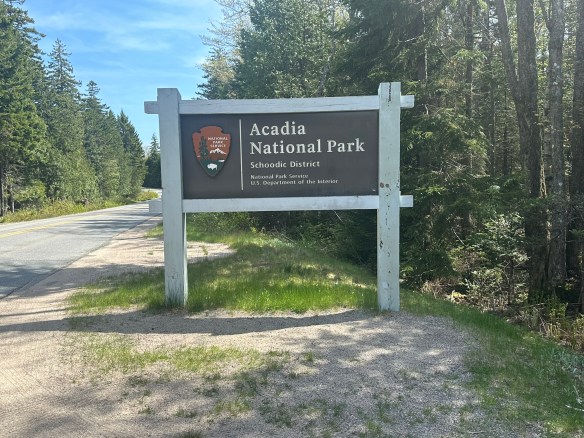
Charles W. Eliot, George B. Dorr, and John D. Rockefeller presented 5,000 acres to the American people in the form of a national monument, which was signed into effect by President Woodrow Wilson. At the time, the park was under the name, Sieur de Monts. More property was donated by wealthy patrons, many of them affluent women, and efforts continued to obtain full national park status. In 1919, President Wilson signed the act establishing Lafayette National Park and Dorr became the first park superintendent. In 1929, congress authorized the National Park Service to accept a donation of land on the Schoodic Peninsula and that was when the park’s current name, Acadia National Park, was adopted.
Photo by S. Resendez
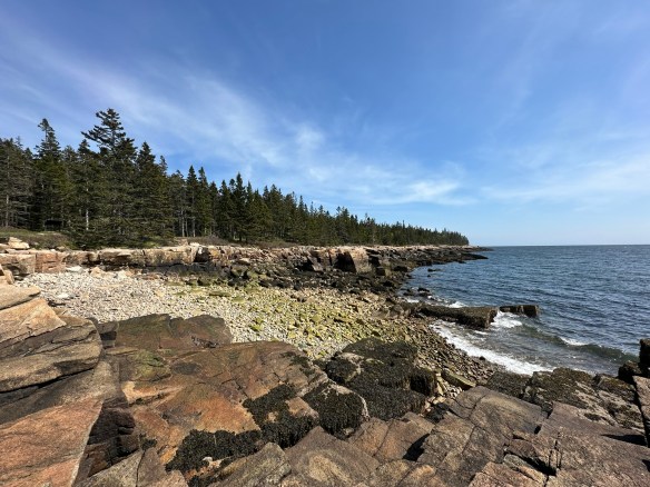
Acadia National Park preserves approximately 50,000 acres in Maine. Ecosystems contained within Acadia include mountains, shorelines, forests, lakes and ponds, steams and watersheds, marshes, swamps, and wetlands. It boasts. more than 1,100 plant species and diverse wildlife from microorganisms and larger animals. It is currently, as of this writing, the 10th most visited national park.
Acadia National Park is usually open 24 hours a day but check the website for specific information regarding operating hours for the visitor’s center. Summer is the busy season but it’s always good to plan in advance because you never know when things might change. Acadia is a huge park and while there are many areas that are accessible to people with disabilities, there are also many areas that are not accessible. The best way to check is to go directly to their accessibility page for specific information.
Photo by S. Resendez
MILE MARKER: Did you know that Acadia National Park was the first national park created entirely from private land donations? Also, Acadia’s famous carriage roads were built by John D. Rockefeller Jr., not for cars, but as a refuge from them. He even designed the roads and bridges to blend naturally into the landscape, using local granite and hand-carved details.
HIKE IT!: There are SO MANY hikes in Acadia, there’s not enough room to list them here. It’s a good thing that Acadia’s NPS website has a whole page that sorts all the hikes for you! Find your favorite hiking trail by location, by environment, by route, or by public transportation. Look here for links that will take you straight to the information you need to hike your hike.
In the mid-1800’s, California was the place to be. Gold had been discovered. The race was on to get the gold and nothing would stand in the way of the prospectors looking to get rich. As is usually the case, there were some obstacles in the way, namely people.
Bridal Veil Falls
Photo by S. Resendez
The Indigenous people of Yosemite Valley called the valley “Ahwahnee” or “gaping mouth-like place”. The Ahwahnee lived in the area for thousands of years, developing a deep, reciprocal relationship with the land, but were eventually devastated by illness and displaced by settlers and park officials. In the end, the Mariposa Battalion, a Euro-American militia entered the area and drove the native Ahwahneechee people onto reservations,
As more people made their way into California, specifically Yosemite Valley, hotels, inns, and stagecoach companies began catering to the early tourists. In 1864, Yosemite was recognized by the federal government as someplace that should be protected. Abraham Lincoln signed the Yosemite Grant, placing Yosemite under the protection of the state of California.
President Teddy Roosevelt and John Muir standing on rock at Glacier Point, Yosemite, May 1903; Yosemite Falls and cliffs of Yosemite Valley in distance.
Photo courtesy NPS [RL012904]
In 1903, President Theodore Roosevelt visited Yosemite and guided by naturalist John Muir, spent three nights camping in the Mariposa Grove and later, in a snowstorm near Sentinel Dome, then finally in a meadow near the base of Bridalveil Falls. This stay led Roosevelt to expand federal protection of Yosemite, and it inspired him to sign into existence 5 national parks, 18 national monuments, 55 national bird sanctuaries and wildlife refuges, and 150 national forests.
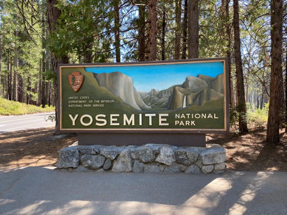
Yosemite National Park is open 24 hours per day, 365 days per year. The Hetch Hetchy area is only open from sunrise to sunset (except for permitted backpackers). There are other park entrances but check the website to see whether or not they are open. All day visitors must exit Hetch Hetchy by sunset. The road is also closed to all vehicles (including backpackers) from sunset to sunrise. Yosemite National Park covers nearly 1,200 square miles (3,100 square km) in the Sierra Nevada, with elevations ranging from about 2,000 feet (600 m) to 13,000 ft. The welcome center is located next to the Yosemite Village Parking and the Village Store in Yosemite Valley. Get help planning your visit and pick up free trail maps, junior ranger booklets, and more at the welcome center. Hours are 9:00 AM–5:00 PM and the Village is open year-round.
El Capitan
Photo by S. Resendez
Things to do are numerous but if you’re visiting during the busy season, you need to make sure you plan ahead. Planning your visit will help to make sure you’re able to see everything you want to see while you’re there.
MILE MARKER: Did you know that some of the Buffalo Soldiers that were stationed at Fort Davis were stationed to park protection duties? After their frontier service, many Buffalo Soldiers were assigned to protect the newly formed national parks, including Yosemite. Between 1891 and 1913, soldiers from the 9th and 24th Cavalry, among others, served as the official administrators and park rangers in Yosemite.
HIKE IT!: There are a million things to do in Yosemite but hiking is the penultimate experience here. In and around Yosemite Valley, there are several day hikes rated easy to moderate that range from 0.5 miles all the way to 13 miles. There are also some shorter, more moderate hikes, that have elevation but if you plan ahead, you can check out the information and get yourself on a trail that suits your abilities. If you’re looking for trails outside of Yosemite Valley, check out Yosemite’s page all about the hiking trails. You’re sure to find something that suits your hiking style.
Thanks for joining us at Two Chicks with Hiking Sticks. We’ve been picking up new subscribers on YT so we thought it would be a good time to take a moment to reintroduce ourselves. Our goal with our all of our content, podcast and blog, is to entertain and educate about the outdoors through experiences that will empower us to explore the rich intersections of culture, history, and the natural world.
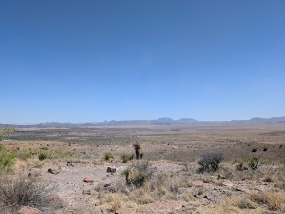
Chihuahuan Desert
Photo by M. Gonzalez
We also think we’re at a good age to encourage other people who have had a long time urge to get into the outdoors and do some hiking but have always felt that perhaps they couldn’t hike long hikes, or maybe they’re recovering from an injury and aren’t sure they’re ready to hike. Or maybe they’re just afraid to get started. If any of those statements sound familiar, you’re in the right place!
We firmly believe that hiking is for everyone! Being outdoors is good for all of us. It’s important to touch grass now and then. To know that if things get too hectic in our daily lives, a walk or hike amongst the greenery can help us all to breathe. Being outside helps bring our blood pressure down. It brings down our stress levels. It helps us to focus. It grounds us.
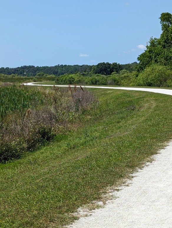
Sweetwater Wetlands Park
Photo by M. Gonzalez
You don’t have to hike miles and miles to gain the benefits of hiking and being outdoors. Research published in 2019 in the Journal of Positive Psychology provides evidence that subjects who spent just five minutes in a natural environment showed significant increases in positive emotions compared to participants who sat in a windowless room.
It’s not only how long a single outing is, but also how often you get out. Shorter, repeated exposures (interval exposure) can bring benefits. Even 10 minute exposures, if repeated over time, show positive effects. And here’s something interesting…these same studies also show that very long durations (hours) don’t always yield proportionally greater benefits, depending on the setting and how strenuous the activity is. This means that short intervals outside can yield the same, if not better, results than long, extended activity!
Comanche Lookout Park
Photo by M. Gonzalez
If you go for a hike (or spend time in nature) just once, even 10-15 minutes will likely give you a mental boost: better mood, lower stress.
More frequent shorter outings may be as or more helpful than infrequent long ones.
Hiking regularly (say, one or more hikes/week) is better than one long hike then many days indoors.
We take you to visit city, state, and national parks. We talk about the culture and the history surrounding them, then we talk about the hikes. And, we have some laughs as we do it. So, what are you waiting for? Grab your hiking sticks, join the Two Chicks, and go “Hike Your Own Hike!”
Glacier Bay National Park and Preserve is more than a stunning wilderness—it’s a living story of ice, culture, and resilience. Once completely covered by massive glaciers, this area is still reshaping itself, revealing dramatic fjords and thriving ecosystems. Home to Tlingit heritage sites, soaring mountains, and wildlife from bears to humpback whales, Glacier Bay invites you to explore its past while experiencing its raw, untamed beauty.
Photo by S. Resendez
The time when the gradual shifting of glaciers began is now referred to as “The Little Ice Age”. It lasted for approximately 550 years and in addition to the extreme cold, there were periods of extreme climate fluctuation that made it difficult for any human beings to survive and thrive. Food scarcity and famine, disease and unrest, plagued the native populations and for at least the last 100 years into the late 1800’s and early 1900’s, the Tlingit people were forced to gradually move off their ancestral lands.
But the shifting of the glaciers also brought out the mysteries of the land and suddenly, a new ecosystem was created which brought attention to the area in and around what we now call Glacier Bay. In 1925, when Glacier Bay became a National Monument, the land in and around Glacier Bay was the ancestral home to the four clans of the Huna (Hoonah) Łingít. In its attempt to preserve and conserve the natural beauty at Glacier Bay, the National Park Service (NPS) fostered new federal laws that severely impacted the lives of the indigenous people. Where they were once free to hunt, fish, and forage the land, new restrictions now curtailed, if not outright prohibited, the Huna Łingít’s ability to live freely on land that was once an integral part of their everyday lives.
Photo by S. Resendez
In December of 1980, President Jimmy Carter signed the Alaska National Interest Lands Conservation Act that created Glacier Bay National Park and Preserve. After becoming a national park, the National Park Service and Hoonah Indian Association, began working together to reestablish and reinvigorate traditional and cultural activities. There remains a concerted effort to collect and preserve oral history amongst the Hoonah. And on the shores of Bartlett Cove, a cooperative venture led to the first tribal house to honor the Glacier Bay since Łingít villages were destroyed by the moving glacier 250 years ago. The Huna Ancestor’s House is open to park visitors and provides opportunities to learn about Huna Łingít history, culture, and their ancestral way of life.
Accessibility: Bartlett Cove has a few short trails, a public dock, campground, Glacier Bay Lodge with the Park Visitor Center on the second level, and the Visitor Information Station. These pathsare not paved, and may have exposed roots and rocks. The Tlingit Trail provides a wheelchair accessible gravel path between the public dock parking area and the front of the Huna Tribal House. While navigable by many new wheelchairs, not all trails meet ADA standards. There is also a beautiful wooden boardwalk that provides access to a viewing deck overlooking a serene pond. This 1/2-mile section of the Forest Trail is accessible and easy to negotiate. For more detailed information about accessibility, visit the Glacier Bay National Park and Preserve website.
MILE MARKER: When Captain George Vancouver sailed by in 1794, he didn’t discover Glacier Bay as we know it — because it was completely covered by ice. A single glacier more than 100 miles long and 4,000 feet thick filled the entire bay. By the late 1800s, the ice had already retreated over 30 miles, revealing the stunning fjords and waterways we see today.
HIKE IT!:Several hiking trails are available to hike during your visit to Glacier Bay. You can view, or print, Bartlett Cove Trails Map for a simple visual of the shorter hiking trails. You can also visit the hiking page at the Glacier Bay NPS site. The best known hike at Glacier Bay would probably be the Forest Trail. It’s a 1 mile loop trail that’s rated as easy. The terrain is mostly flat and trail surface varies between dirt, gravel and boardwalk. There are benches and viewing platforms so factor in time to have a seat and enjoy nature. There is also a ranger led guided walk along this trail every afternoon.
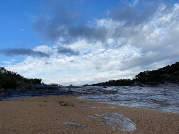
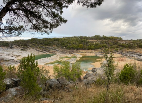
There are signs that approximately 10,000-12,000 years ago, in the area we now recognize as the central Texas hill country, the Paleoindian people were utilizing the natural resources of the area to create tools for hunting megafauna such as bison and wooly mammoth. The grasslands of central Texas were the perfect environment for these animals. Add abundant water and flint, or as the Spaniards called it, pedernal, used to create those tools for hunting, and we can see why the area was such a draw for the indigenous people.
Fast forward to the 16th century, Spanish explorers and missionaries are making their foray inland towards central Texas. Lipan Apache are roaming the area and the Franciscans in charge of the missions in San Antonio are suggesting that a mission may need to be built in this part of Texas, as well. While that suggestion never comes to fruition, the influence of the Spaniards is cemented on the land. While in the area, the Spanish explorers begin to refer to the flowing water as the Pedernales River, due to the abundant amount of flint, or pedernal, in the riverbed.
After Texas became a state in 1845, small farming communities began to develop. and in the late 1800’s, the area in and around Pedernales Falls grew, but by the 1930’s, that same area began a decline. Lack of population growth, a depressed economy, and drought, probably helped to diminish and keep the local citizens to the bare minimum. The surrounding land was used for grazing until the original owner sold the land to Charles (C.A.) and Harriet Wheatley.
Photo by S. Resendez
The Wheatley’s named their new ranch, the Circle Bar Ranch and began improvement projects. They built a road that connected their ranch to the nearest county road and began building their home. They brought in purebred Hereford cattle and eventually, steer and goats. Although the Wheatley’s enjoyed hunting, they strongly believed that natural resources should be preserved and protected for the enjoyment of future generations. The Wheatley’s were prolific conservationists. Charles Wheatley helped to organize the National Wildlife Management Institute and was one of the founders of the Texas Fish and Game Commission. He was a friend of Governor Neff, who was responsible for creating the Texas State Parks system. Harriet Wheatley was also a lover of nature who enjoyed hunting and was active in the San Antonio Conservation Society, the Bexar County Girl Scouts, and the Blue Bird Auxiliary. She and Charles were both known to be expert fly fishermen and she even published a book entitled, Lady Angler: Fishing Hunting, and Camping in the Wilderness Areas of America.
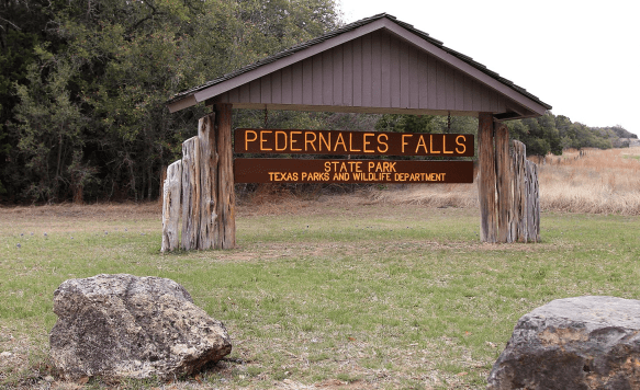
In 1969, Harriet Wheatley sold the ranch to the state of Texas with her wish that “that it be conserved, and all of the wildlife be taken care of, and that it be enjoyed from generation to generation.” The park officially opened in 1971 as Pedernales Falls State Park. The park’s terrain typifies the Edwards Plateau, with woodlands, cedar brakes, grasslands, and lush riparian zones lining the Pedernales River.
The Pedernales Falls State Park is located at 2585 Park Road 6026, Johnson City, TX 78636. The park is open daily open daily and the office is open 8 a.m. to 4:30 p.m. The park’s phone number is (512) 389-8900.
Accessibility: Call ahead for specific information regarding building accessibility. They do have an all-terrain wheelchair available for use in the park. Contact the park to reserve it for your visit.
MILE MARKER: Beneath the falls and limestone shelves, the riverbed preserves fossilized tracks of ancient creatures. If you look closely in certain areas, you can spot impressions of prehistoric marine life that lived here when the Hill Country was covered by a shallow sea more than 100 million years ago.
HIKE IT!: Ten trails, from easy to challenging, are available for hiking, biking, and horseback riding. Trails vary in length from half mile to ten miles mean there are trails for every type of hiker! For more detailed information about the types of trails, check out the hiking trails page on the Pedernales State Park website.
Have you ever wanted to know what other hikers carry in their hiking packs? This is your chance to take a quick peek into the backpacks of the Two Chicks.
We’ll talk a bit about what we carry and why we carry it. We hope you enjoy this podcast and we hope it inspires you to do some hiking!
Don’t forget to check out our Hiking Information page for lots of downloadable checklists you can use for your next hike. Also, what’s in your pack? Drop a quick comment down below and tell us what you carry and what’s the one thing you won’t leave behind when YOU go hiking.
View of the Shenandoah River from the Murphy-Chambers Farm Overlook.
Photo courtesy of NPS/Autumn Cook
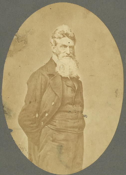
Near the area where the Potomac and Shenandoah rivers meet, a group of nineteen men, led by Captain John Brown, invaded the arsenal at Harpers Ferry. The group then took several of the residents of the surrounding neighborhood as prisoners, while emancipating several slaves, and held off United States troops, under the command of Colonel Robert E. Lee, for almost 30 hours, before finally being captured, wounded, or killed. Captain John Brown was captured, tried, convicted, and executed for high treason and inciting slaves to insurrection. While this endeavor appears to have been a failure, the actions of the Captain and the men who accompanied him helped to launch the United States into the Civil War.
Captain John Brown
Photo by S. Resendez
Because Harpers Ferry was chosen by George Washington to be the location of the 2nd national armory in the US at that time, Harpers Ferry was a prime spot for a faction to seize control. Between 1861 and 1865, the town of Harpers Ferry changed hands eight times. Strategically located at the confluence of two rivers and two railway lines, the arsenal at Harpers Ferry and its strategic location made it a hotbed of invasion and occupation that continued throughout the Civil War. In October of 1867, after the Civil War, Storer College was founded. It became the first higher education institution in West Virginia open to African Americans.
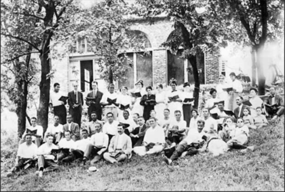
From 1909-1968, John Brown Fort stood on the site of Storer College on Camp Hill in Harpers Ferry. In this circa 1915 photograph, Storer College students, faculty members, and their families pose in front of the fort during an evening choral session. Year: 1915. Image Credit: Historic Photo Collection, Harpers Ferry NHP.
African American families continue to maintain their deep connections to the area in and around Harpers Ferry and today, more than 250 years after the first family settled the area, Jefferson County still boasts the longest established African American community in the state of Virginia.
In 1944, Harpers Ferry National Monument was authorized by Congress and in 1963, the park was renamed Harpers Ferry National Historical Park. Today, Harpers Ferry is not only a significant historical site, it also boasts a wide and varied ecosystem that encompasses a deciduous forest, flood plains, mountains, rivers, streams, wetlands, marshes, and swamps. “The park is home to approximately 14 amphibian,18 reptile, 36 mammal, 30 spider, 43 fish, 174 bird, and 276 insect species.”
Harpers Ferry National Historical Park is open year round with the exception of Thanksgiving Day, December 25, and January 1. The Visitor Center is located at 171 Shoreline Drive, Harpers Ferry, WV 25425 and is open daily from 9a to 5p. Shuttle buses run every day the park is open, every 10-15 minutes. Park museums/exhibits and restrooms in the historic Lower Town are open daily from 9 a to 5 p. Hours change seasonally so make sure you visit the website or call for the most up to date information.
Accessibility: The park has two wheelchairs available that may be borrowed by visitors upon request. The park’s shuttle buses are equipped for those with physical limitations. The buses kneel and have lifts to accommodate those who are unable to utilize the stairs. For more details on accessibility for physical, hearing loss, low vision/blindness, please check the website.
MILE MARKER: Harpers Ferry is an anchor point on the Lewis & Clark National Historical Trail. It served as the starting point for the Corps of Discovery’s journey westward on the Lewis & Clark Expedition in 1803.
HIKE IT!: There are several trails with varying levels of length and difficulty ranging from 1 mile to 6.5 miles long. Be sure to check out the hiking page of the Harpers Ferry NPS website for detailed information on the hikes and the Appalachian Trail!
Loudoun Heights Trail in the fall
Photo courtesy NPS / Volunteer Devin Taggart
We’re covering new ground today as this is our first time exploring an NPS National Historic Trail. Based on the NPS definition of what denotes a National Historic Trail, we learn that a National Historic Trail is a “long-distance route that follows and commemorates a historic path of travel that changed the history and character of the U.S.” Today these routes offer opportunities to visit surviving sites, trail segments, and defining places of history as we learn about the diverse stories they tell. According to the NPS site, there are currently 19 trails that range from 16 miles long to a little over 5,000 miles long. For more information about all the trails, click on the link here.
Map courtesy of NPS
Beginning in Mexico City and winding its way through Texas and up into Louisiana, the Camino Real de Los Tejas covers approximately 2,600 miles. This isn’t a “hikeable” trail by definition, rather it should be considered as a chance to follow the historical footsteps of the people who traveled across countries and through inhospitable lands to begin settling the areas we now recognize as Texas and Louisiana.
Spanish Missions in Texas
Photo by M. Gonzalez
Because we’re writing this from our home base in San Antonio, it’s easy to talk about where the trail leads us from here, but before it got to San Antonio, the trail meandered up from Coahuila, Mexico, near the Rio Grande, to Laredo, Texas, in and around Goliad, Texas (where the Camino Real de Los Tejas museum is located), and up through Victoria and Cuero. From here, the trail veers back towards San Antonio, or continues on to Bryan, Texas. There are also documented starting points, once the border was crossed, in Eagle Pass up to San Antonio. From San Antonio, the road continued on through New Braunfels (which later became a German settlement), up to San Marcos, to Austin or towards Bastrop (home of the Lost Piney Woods). From there, the branches seemed to gather near Crockett and continue on towards Nacogdoches and on towards Louisiana. The Camino Real de Los Tejas split or combined according to the seasons. If the weather affected the planned route, the way could be rerouted to avoid flooded areas or other hazards along the way.
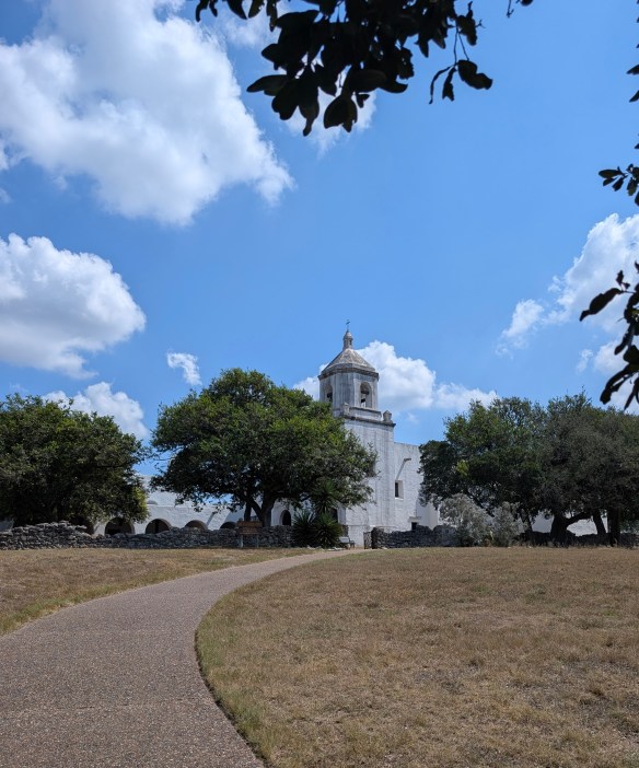
There are several missions along this corridor, some missions having been moved from other areas closer to the Gulf of Mexico, and rebuilt to follow the San Antonio River, going east towards Louisiana or west towards California. In this part of Texas, the most famous missions in and around this area are, arguably, the San Antonio Missions National Historical Park, a UNESCO World Heritage site. However, other missions pepper the way along the Camino Real, such as Mission Nuestra Señora del Espíritu Santo de Zúñiga in Goliad State Park.
Mission Nuestra Señora del Espíritu Santo de Zúñiga
Photo by M. Gonzalez
This amazing spot along the Camino Real showcases the work of the CCC (Civilian Conservation Corp) which was instrumental in building, conserving, and restoring a variety of buildings in and around Texas. While Mission Espiritu Santo was established in the mid-1700’s, it was the fourth mission with the same name and after several relocations, found its final home in the area known as La Bahía, which later became known as Goliad, Texas. As time passed and the mission was no longer needed, Franciscan Priests finally closed this mission in 1830.
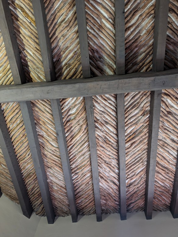
Between 1933-1942, the men of the CCC followed the plans to meticulously reconstruct the mission under the direction of a young architect by the name of Raiford Stripling. But before they would begin their project, they had to work on a “beginner” project in order to ensure that everyone understood the methods used to build the original mission in the 1700’s. In order to practice, they set about making a cottage for the park’s “superintendent to be”. In building this cottage, the men of the CCC could practice their brick making skills, along with learning to work with native materials, and making latilla ceilings (a traditional Southwestern design element consisting of peeled branches or small pieces of wood (latillas) laid between beams (vigas) to create a rustic, decorative ceiling). They learned how to hand carve large, ornate doors and forge iron hinges and once the cottage was finished, they understood what needed to be done to recreate the actual Mission de Espiritu Santo.
Latillas and Vigas
Photo by M. Gonzalez
The Mission Nuestra Señora del Espíritu Santo de Zúñiga is the highlight of Goliad State Park and rightfully so. This mission, reconstructed on top of the its original 1749 foundation and wall remnants, is a testament to architecture and history as we make our way along the Camino Real de Los Tejas on the way to Louisiana.
If you’re interested in learning more about the Royal Road or following in the path of long ago Spanish settlers, look here for a FREE downloadable checklist of places to visit along the Camino Real de Los Tejas.
But there’s more to Goliad, Texas than meets the eye! We’re not done with our stop here just yet because in the midst of traveling this royal road through history, we also find ourselves in the heat of the battle for Texas independence! We’re going to look at, and talk about, flags you might not have known even existed! Stay with the Two Chicks for more adventures in Goliad, Texas!
MILE MARKER: A staircase, carved from two logs, could be placed in tight spaces that might have otherwise only had room for a ladder. Known as “Escaleras de Madera” or Staircases of Wood, they were also sometimes referred to as “Witches Staircases” as folklore denotes the stairs were designed to prevent witches from climbing them.
Escalera de Madera
Photo by M. Gonzalez
HIKE IT!: There is a paved trail that runs through the park and connects the Presidio La Bahía to Goliad State Park and continues on towards downtown Goliad. Within the park, there is a trail that follows alongside the San Antonio River. It’s easy to park in the parking lot at the state park and walk the trail which is relatively flat and accessible. There are also hiking trails at the Medina Valley Natural Area. This area, just south of San Antonio, was part of the Camino Real de Los Tejas and there are some lovely trails to hike along the Medina River.