If you’ve checked out our video podcasts and if you’ve enjoyed the content we’ve been sharing with you, we would REALLY appreciate it if you would go to our YouTube Channel and SUBSCRIBE.
We promise you won’t find a mailbox full of emails you don’t need, you’ll just be helping us on YouTube so we can get our content out and build our audience.
When you click the link above, it will take you directly to our YouTube Page. From there, it’s as easy as clicking “Subscribe”. That’s it! Super easy and you’ll be helping us out. Thanks in advance for your help!
(Liking our posts here and subscribing to our blog posts also helps us out. We appreciate all of you who are taking the time to read our posts!)
There are signs that in around 1849, Mescalero Apache watered their horses at the Mescalero Springs. Later, Mexican farmers dug canals by hand to irrigate their crops, which they later sold to people who lived in Fort Davis. The farmers called these springs the San Solomon Springs. In 1927, the springs were dredged and a canal was built to better utilize the flow of the water. Records show that the springs around Balmorhea have been in use for almost 11,000 years.
San Solomon Springs Motor Courts Photo by S. Resendez
In 1934, the State Board of Texas acquired approximately 46 acres around the San Solomon Springs. The Civilian Conservation Corp (CCC) arrived at the springs in July 1934 and began work on building what would later become Balmorhea State Park. The CCC created the 1.3 acre pool around the springs. They also built the concession building, the bath houses, and the motel court using native limestone and hand hewn adobe bricks.
Balmorhea Swimming Pool
Photo by S. Resendez
The San Solomon Springs is the largest in a series of 6 springs located in the Chihuahuan desert. The Balmorhea State Park Swimming Pool is the world’s largest spring-fed pool and often referred to as the crown jewel of the Texas State Parks System. The springs originally emptied into what is known as a ciénga or desert wetland. Construction of the swimming pool, back in 1934, resulted in the destruction of the natural springs which were rebuilt and fashioned into two man-made ciéngas.
Ciénega
Photo by M. Gonzalez
There is an overlook by the RV section of the park for visitors to look for wildlife like deer, javelina, squirrels, turtles, lizards and dragonflies, which also utilize the springs. San Solomon Springs also serves as a stop for resident and migratory birds and is home to several rare and endangered species of snails and fish. San Solomon Springs is the largest spring in the Balmorhea area, and the habitat at Balmorhea State Park is very important for the conservation of these species.
Balmorhea State Park is located at 9207 TX-17, Toyahvale, TX 79786. Daily entrance fee for adults is $7 and free for children 12 and under. Park hours are from 8a to 7:30p or sunset (whichever comes first) and office hours are from 8a-5p. They often reach capacity and highly recommend reservations for both camping and day use. You can reserve passes online or by calling the customer service center before you visit. Check the park’s Facebook page for updates. Read their FAQ page for more detailed information about park and pool rules. Make sure you plan your visit before going!
Chihuahuan Desert Nature Center Entrance Photo by S. Resendez
About 41 miles south and just outside of Fort Davis, Texas, sits the Chihuahuan Desert Nature Center. The Chihuahuan Desert Research Institute (CDRI) is a nonprofit organization that was established in 1973 and housed in Alpine, Texas. Its principal founders were science professors at Sul Ross State University, a university that the institute continues to work closely with today. Today, the CDRI is the Chihuahuan Desert Nature Center and is located on 507 acres in the foothills of the Davis Mountains.
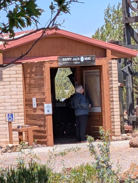
Susan intently studying the locations of the mines!
Photo by M. Gonzalez
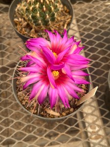
The Nature Center is open year round. If you’re interested in exhibits about geology, history, and culture of the Chihuahuan desert, there is a mining exhibit detailing desert mining and the geological changes that have occurred in the Trans-Pecos of Texas over the last 2 billion years! A bird blind is available for birders, and there’s a cactus museum which houses over 200 species, sub-species, and varieties of cacti and succulents.
Photo by M. GonzalezPhoto by M. GonzalezPhoto by S. Resendez
If you don’t feel like hiking, there are botanical gardens which encompass a wildscape garden, a self-guided stroll through a Trans Pecos Natives garden, a pollinator garden trail, and a native grasses exhibit.
Check the website for Chihuahuan Desert Nature Center before heading out. The Center is located off of Hwy 118, 4 miles SE of Fort Davis at 43869 St. Hwy. 118, Their hours are Monday-Saturday, 9a-5p.
MILE MARKER: Would you believe that cactus can be found as far north as Canada?! Some species have evolved to withstand cold temperatures and dry conditions. Southern prairies and certain regions by the Great Lakes, provide habitats with enough sun, well-drained soil, and suitable temperatures for cacti to thrive.
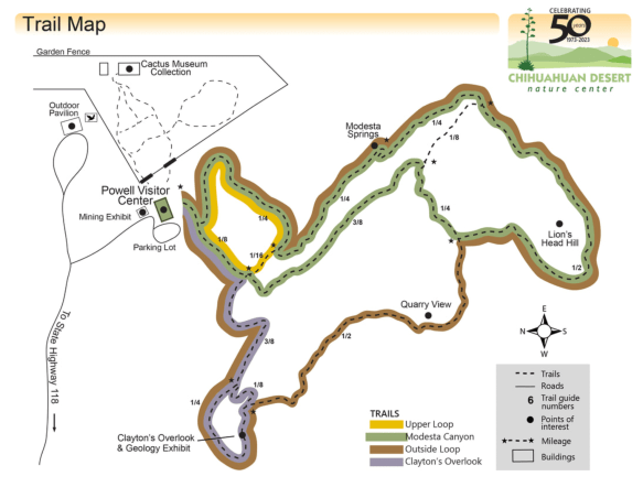
HIKE IT!: There are lots of great hiking trails at the Chihuahuan Desert Nature Center. There are 5 trails ranging from .25 mile (scenic loop inside the botanical garden) to a 2.5 mile loop, which is considered a strenuous hike. Remember, you are hiking at an elevation of approximately 5,000 feet! Consider the weather and your own physical abilities. While the trails are mostly earthen, they may be uneven so take your hiking sticks, sunscreen, a good hat to cover your head and face, and plenty of water. After all, you’re desert hiking!
Trail Map for CDNC
Photo courtesy of Chihuahuan Desert Nature Center
Got questions? We might have some answers!! Tune in for a short chat about questions or comments some of you have mentioned either on our Facebook Page, YouTube, or Instagram. If you have any other questions or comments, feel free to write them below. If you let us know, we’ll hand out some more trail mix in a future podcast. Thanks for listening!
Minidoka, one of ten incarceration sites established during World War II, stands as a powerful reminder of the injustices faced by Japanese Americans forcibly removed from their homes during the onset of World War II.
In the 1880’s, Japanese immigrants began making their way to America, primarily to Hawai’i, where they worked in the sugar plantations. From there, many Japanese immigrants made their way to the mainland where they worked clearing mines, building the railroad, at sawmills, and in the fields. This was due in part to The Chinese Exclusion Act of 1882, which was the first significant law prohibiting immigration of Chinese laborers for 10 years.
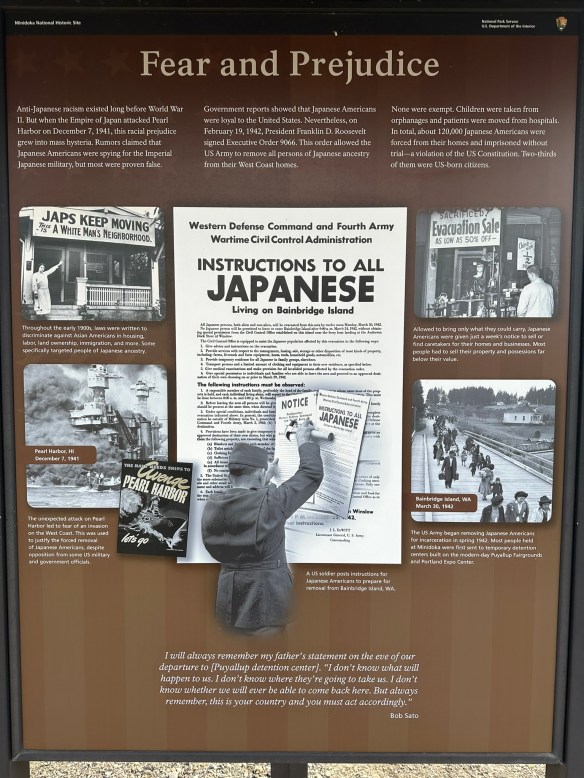
By the early 1900’s, Japanese families had assimilated into American culture. With a strong presence in Hawai’i and along the entire west coast of the United States, Japanese American families were fully productive members of society. They were business owners, educators, entrepreneurs, and neighbors. Despite lingering racist sentiment, much of it stemming from the Asian Exclusion Act of 1924, Japanese-American families had tentatively created a place for themselves in America. Then, on December 7, 1941, Imperial Japan launched an unprovoked attack on Pearl Harbor. The United States declared war with Japan and life for Japanese Americans immediately changed.
Photo by S. Resendez
Predicated by the Asian Exclusion Act of 1924, on February 19, 1942, President Franklin D. Roosevelt signed Executive Order 9066, declaring certain areas within the United States as “war zones” thus enacting the removal of any and all Japanese Americans from their homes, forcing them into imprisonment without the benefit of due process. This remained in effect for the duration of the war. Despite some opposition and varied court cases filed against it, the executive order was not overturned until 1944.
Japanese Americans were first sent to temporary detention facilities, usually animal stables, racetracks, or fair grounds, and were held there until they were transported to their assigned War Relocation Camp. Ten major camps were set up for Japanese-American relocations. Minidoka was just one of them.
Minidoka National Historic Site is located in Jerome, Idaho, in the south-central part, not too far from Twin Falls. The concentration camp sat on approximately 33,000 acres and housed approximately 13,000 people, mostly from Washington, Oregon, and Alaska. The compound consisted of over 600 buildings, including the barracks where families lived. Before families arrived at Minidoka, they were given little to no notice that they had to vacate their homes. They were not allowed to bring anything they could not carry themselves.
Upon arrival at Minidoka, the prisoners learned that the camp was barely able to house all the incoming. Barracks had been hastily built using green wood and tar paper. One young man wrote of getting off the bus and walking into a dust storm. The minimally built shelters did nothing to keep out the elements as the green wood shrank and created gaps for the wind, dust, and rain to get through. There was no privacy in the large, shared buildings, and as an added insult to injury, prisoners were forced into labor, building more of the barracks that would be needed to house the hundreds of people coming in daily. Even the plumbing and sewage system wouldn’t be completed for several months. Across the nation, over 120,000 people were forced to live in these camps, in horrific conditions, with many of them being U.S. citizens,
Photo by S. Resendez
Minidoka consisted of 36 residential blocks with 12 barracks, a mess hall, and a latrine. Each barrack was 120’x 20’, which was divided into six units. Each unit housed a family or a group of individuals. Each unit had one lightbulb and one coal burning stove. The walls dividing the units did not extend to the ceiling and the barracks had no insulation. Bathrooms consisted of a row of toilets and a row of showers. There were no partitions or dividing walls. Each block held a mess hall which served as a “hub” of sorts for families to gather and eat and hold community events like holiday parties or dances.
While not ideal, the families and individuals living within the concentration camp made the best they could of their situation. They educated their children in makeshift schools. They created sports teams, building a baseball field and basketball courts so they could play. They hosted cultural events amongst themselves, held religious services, and even published their own newspaper. The Japanese American people proved to be resourceful as well as resilient.
Baseball Field
Photo by S. Resendez
While in the concentration camps, males were offered the “opportunity” to serve their country as long as they signed acknowledgment and swore “unqualified allegiance” to the US and that they also forswore allegiance to any foreign power, including the Japanese Emperor. Most of the interred men wanted to serve their country but were angry at having to declare their allegiance to a country for which they never gave up their allegiance. How could they renounce allegiance to an emperor they never swore allegiance to in the first place? In the end, the men who decided to answer “no” to the questions regarding their allegiance were removed from the internment camps and sent to high security camps or detention centers. Most of the 30,000 Japanese American men who saw battle became part of 442nd Regimental Combat Team and the 100th Infantry Battalion, with many still who became part of the Company B of the 1800th Engineering Battalion. In all, they were awarded six Distinguished Service Crosses during the first eight weeks of combat and three Presidential Unit Citations. Eventually, joining the 442nd Combat Team and the 100th Infantry Battalion, Company B of the 1800th Engineering Battalion is often recognized as the most decorated American unit for its size and length of service.
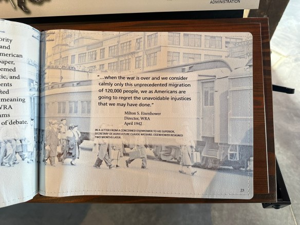
“Americans are going to regret the injustices that we may have done.”
Photo by S. Resendez
In late 1944, in the case of Ex parte Mitsuye Endo, the Supreme Court ruled that Executive Order 9066 was unconstitutional. Also being reviewed by the Supreme Court in 1944, was the case Korematsu v. United States. In this case, (which was happening at almost the exact, same time as the Mitsuye Endo case) the use of the internment camps was upheld and is often cited as “one of the worst Supreme Court cases of all times”. In his dissent, Justice Frank Murphy said this,
I dissent, therefore, from this legalization of racism. Racial discrimination in any form and in any degree has no justifiable part whatever in our democratic way of life. It is unattractive in any setting, but it is utterly revolting among a free people who have embraced the principles set forth in the Constitution of the United States. All residents of this nation are kin in some way by blood or culture to a foreign land. Yet they are primarily and necessarily a part of the new and distinct civilization of the United States. They must, accordingly, be treated at all times as the heirs of the American experiment, and as entitled to all the rights and freedoms guaranteed by the Constitution.~~Korematsu v. United States, 323 U.S. 214 (Supreme Court of the United States 1944)
When the camps closed and the prisoners were released, they were given the paltry sum of $25 and a one-way bus or train ticket to the destination of their choice. Despite the fact that the war was over and the despite the fact that Japanese Americans fought for their country alongside other American soldiers, anti-Japanese sentiments made integrating back into their communities difficult.
Life After Minidoka
Photo by S. Resendez
After the war ended, President Truman signed the Japanese American Evacuation Claims Act of 1948. This entitled anyone who was incarcerated to file claims for damages and loss of property but reparations did not come close to the $148 million dollars claimed. Only $37 million dollars had been allocated for damages. After the Civil Rights Movement, reparations were again sought and in 1980, the commission on Wartime Relocation and Incarceration of Civilians was signed into law. They discovered that the incarceration was the result of “racial prejudice, wartime hysteria, and a failure of political leadership.” In 1988, the Civil Liberties Act of 1988 was formalized, with President Ronald Reagan formally acknowledging the unconstitutional nature of the internment camps. Japanese Americans who were wrongfully imprisoned finally received reparations of $20,000 along with a formal apology.
Survivors and family members, friends, and allies of the people who were incarcerated at Minidoka participate in an annual pilgrimage. To learn more about their pilgrimage, click here.
The Minidoka Visitor Center is located at 1428 Hunt Road in Jerome, Idaho. If the visitor center is not open during your visit, you can check the after hours box for brochures. The historic site grounds are open year-round for self-guided walking tours. The Visitor Center is open Friday, Saturday, and Sunday from 10a to 5p. Restrooms are unavailable if the Visitor Center is closed.
The books mentioned in the podcast are Facing the Mountain: A True Story of Japanese American Heroes in World War II by Daniel James Brown and The Train to Crystal City: FDR’s Secret Prisoner Exchange Program and America’s Only Family Internment Camp During World War II by Jan Jarboe Russell
MILE MARKER: Despite the limited rations given at the internment camp, residents created gardens, grew crops, built hog and poultry farms and became completely self-sustainable. They even managed to create their own tofu plants.
HIKE IT!: Minidoka National Historic Site offers 1.6 miles (2.5 km) of gravel walking trails which is basically a self-guided tour of the grounds. It is essentially flat and not difficult to navigate on foot. It is not considered an “accessible” trail. There is plenty to see and read along the route. The sign boards offer stories of information regarding the activities on the land.
“The mountains are calling and I must go.” – John Muir
11,000 years ago, humans began to venture into the untamed wilderness we now know as Rocky Mountain National Park. Replete with an abundance of wild animals, flora, fauna, and glacier-sculpted mountains, the Ute came to settle in the meadows and the valleys, eventually moving on in the 1700’s. With the Louisiana Purchase of 1803, the United States acquired the land that we know now as the Rocky Mountain National Park. In the late 1850’s, the gold rush in and around Pike’s Peak brought prospectors to the area. Hunters and trappers also began to discover the abundance of wildlife in the rugged area and despite the harsh winters, ranchers, hunters, miners, and homesteaders began to settle.
As tourism built, a conservation movement was already underway. Now renowned naturalists, John Muir, Gifford Pinchot, and Teddy Roosevelt, were instrumental in establishing the Estes Park Protective and Improvement Association. Enos Mills, a naturalist and nature guide began promoting, in earnest, the creation of a national park. After years of exhaustive lobbying, lecturing, and letter writing by Mr. Mills, President Woodrow Wilson signed the Rocky Mountain National Park Act in 1915, despite opposition from miners and loggers in the area.
During the depression of the 1930’s, the CCC (Civilian Conservation Corp) helped the National Park Service to build Trail Ridge Road. This was an integral part of the park because unlike other national parks at that time, there was no rail service to take tourists to the park. Rocky Mountain National Park was primarily an “auto park”. This meant that roads were a necessity for tourists to be able to experience all the beauty the park had to offer.
Rocky Mountain National Park hosts approximately 4 million visitors a year, with a record high of 4.7 million back in 2020.
There are 3 main entrances:
Grand Lake Entrance if you wish to go clockwise on Trail Ridge Road.
Beaver Meadows The entrance to get you to Bear Lake and you can also reach Trail Ridge Rd.
Fall River Entrance if you wish to go counter-clockwise on Trail Ridge Road and a good place to see bighorn sheep.
As of the date this post was written, timed entry reservations are not needed in the spring and fall seasons. After May 23rd, you MUST make a timed entry reservation and if you wish to include a visit to Bear Lake, that must be stipulated with your timed entry reservation. Make sure you go to the Rocky Mountain National Park website and check out the Plan Your Visit section. Always make sure you’re looking ahead and planning your trip. Entrance fees can vary with your age and passes can be purchased ahead of time. Cash is NOT accepted so plan to use your credit card. There are fee-free entrance days but if you choose to go on those days, be aware that the park entrances may have extra long lines for entry. Everything you need to know is on the website so decide what time of year you’d like to visit, plan ahead, then go! If you live in and around the Rocky Mountain National Park and visit often, you might consider purchasing a transponder for your vehicle. Transponders are for park visitors who visit the park frequently, especially before 9a and after 2p, outside of the timed entry window. Check the park information page for more information about transponders.
There are approximately 355 miles of hiking trails throughout the park. Some good, simple hikes to do – especially when you are coming up to this altitude and need to take it easy.
Sprague Lake .7 miles (loop)
Bear Lake .7 miles (loop)
Alberta Falls 1.6 miles (in and out)
There are also many more moderate, difficult, and longer trails, too. Be sure to check out the Park newspaper for all the trail information and always check with the rangers on trail conditions before you head out, especially if you’re hiking in the spring and the fall, when weather can quickly take a turn.
If you’re not interested in hiking and just want to bask in the glory of the beautiful Rocky Mountains, take the Trail Ridge Road up to Alpine Ridge and the Alpine Visitor Center. Did you know that Rocky Mountain National Park has many aspects of the boreal forest? While not in the continuous range of the geographic boreal forest, scientists have noted that many trees and animals in the Rocky Mountain National Park are the same as what you would find in the boreal forest that stretches from Alaska to New Foundland, and through Russia.
Feeling a little adventurous? While Trail Ridge Road is the highest, continuous, paved road in the nation, the Old Fall River Road is a scenic road that reminds you to slow down and enjoy the scenery. Old Fall River Road is an 11 mile long, one-way, gravel road. The speed limit is 15 mph and will take you, approximately, one hour to complete. There are several switchbacks and if driving up a road with no guardrails makes you antsy, this road may not be for you. But it is a one-way road so you will not encounter opposing traffic. Most of the people who take this road are driving it because they’re in no hurry. There are wider spots for you to pull over if someone does want to pass you. If you have the time, I would suggest taking Old Fall River Road up to Alpine Ridge and taking the Trail Ridge Road back down. Adventure awaits!
Rocky Mountain National Park is open year round, 24 hours a day, 365 days a year. It is located at 1000 US Hwy 36 Estes Park, CO 80517
The Information Office is open year-round: 8:00 a.m. – 4:00 p.m. daily in summer; 8:00 a.m. – 4:00 p.m. Mondays – Fridays and 8:00 a.m. – 12:00 p.m. Saturdays – Sundays in winter. Recorded Trail Ridge Road status: (970) 586-1222.
Information on accessible trails can be found here and all-terrain wheelchairs can be reserved at no cost to you. Just call the Estes Park Mountain Shop at 970-586-6548.
MILE MARKER: There were so many women trailblazers that contributed to the development and conservation of this park, they could have a blog post of their own. Homesteaders, authors, teachers, and conservationists, these women were an integral part of making Rocky Mountain National Park the jewel it is today. To read more about them, go here to the history of the park and learn more about these female trailblazers!
HIKE IT!: There are so many trails to hike at Rocky Mountain National Park, there really are too many to list. But, the website offers a wonderful page of suggested hikes broken down into lake hikes, waterfall hikes, and summit hikes. Further research will also take you to pages of hikes based on the time of year you will be visiting. And don’t forget, “Hike your own hike!”