Taking a Deep Dive into Carlsbad Caverns: Stalagmites, Stalactites, Draperies, and Popcorn!

Carlsbad Caverns Entrance Sign Photo courtesy of NPS

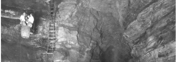
Imagine a time when, if you wanted to travel down into Carlsbad Caverns, instead of hiking or taking an elevator down, you had to load yourself up into a big, old, guano harvesting bucket and have people lower you down. Would you do it? At one time, lots of people did! People wanted to know what sort of world was beneath the surface of the earth. What lives down there? What does it look like? What is it like to be below the surface of the earth?!

Entering Carlsbad Caverns via guano mining bucket Photo courtesy of NPS

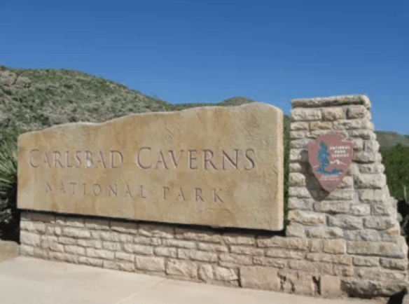
There was enough intrigue and curiosity about these caverns that in October of 1923, President Calvin Coolidge put out a proclamation denoting Carlsbad Caverns a National Monument. What is interesting about that proclamation is that even while recognizing Carlsbad as something that needed to be preserved, its size and depth were still not fully known. The proclamation itself uses phrases like, “extraordinary proportions” and “vast chambers of unknown character and dimensions” and even notes that there was, at that time, one entrance but also included “such other entrances as may be found”. Despite the unknown aspect, everyone recognized that it was in our nation’s best interest to protect this cave. In May of 1930, Carlsbad Caverns was fully established as a National Park.

Since then, we have learned that Carlsbad Caverns encompasses over 300 limestone caves in what was discovered to be a fossil reef that was “laid down by by an inland sea about 265 million years ago”. Above ground, there were signs that the land in that area had been utilized by Indigenous people, probably Mescalero Apaches, as early as 1200-1400 years ago. Spanish explorers showed up in the mid-1500’s and laid claim to the area. Eventually, as the Spaniards left, settlers worked their way through the Guadalupe Mountains. As time passed, travelers stopped in and around the general area and began to build ranches and farms. In 1898, a 16 year old farmhand by the name of Jim White entered the cave for the first time. Jim White eventually became the main guide to reporters, photographers, geologists, and geographers who wanted to learn more about the caverns. After passing away at the age of 63, for his exploration, guide services, and promotion of sharing the caverns with the public, he was unofficially honored with the title of “Mr. Carlsbad Caverns”.

Stalactites and Stalagmites…they still confuse me. Photo by S. Resendez

In 1925, the first trail into the cave was built, eliminating the need to be lowered in a guano bucket. In 1963, the bat flight amphitheater was built at the natural entrance and began allowing visitors to sit and watch the bats take flight.

Today, if you’d like to visit Carlsbad Caverns National Park, you will need to go to their official NPS website and look for information on how to make a timed reservation or call 877-444-6777. In addition to making your timed reservation, expect to pay your entrance fee and to bring your ID along with your timed pass when it’s time for your visit. Cavern entrance hours are from 9:30a to 2:30p with the last reservation time being 2:15p.

Bat Flight Amphitheater Photo courtesy Carlsbad Caverns NPS / Peter Jones

If you’re only interested in watching the bat flight, you won’t need a reservation and there is no fee but seating at the amphitheater is first come, first serve, so get there early if you want to make sure you’ll have a place to sit. The bat flight program is held every evening from April through October. Bat flight takes place at the Bat Flight Amphitheater, which is located at the Natural Entrance to Carlsbad Cavern. The start time for the program changes as the summer progresses and sunset times change so make sure you check on the website before you head out. Bat flight programs may also be canceled due to inclimate weather, so again, check ahead of your visit! **Insider Tip** The best bat viewing months are August and September when baby bats born earlier in the summer begin flying with the colony. Also, migrating bats from colonies further north often join in the flights. Are you a morning person? Early risers (approx. 4-6 a.m.) can watch for the bats as they re-enter the cavern! Bat entrances often come with spectacular dives from heights of hundreds of feet. Remember: To protect the bats, electronic devices are not allowed at the Bat Flight Program and surrounding area. Electronic devices include cameras of any kind, laptop computers, cell phones, iPads, iPods, tablets, and MP3 players.

Bat Flight from inside Natural Entrance Photo courtesy of Carlsbad Caverns NPS / Peter Jones

If you’ve never been to Carlsbad Caverns, the NPS website offers a webpage designed for first time visitors. Make sure you visit it for more detailed information about what to expect for your visit to the cave. Visitor hours are from 9a to 5p. Cave hours are from 9:30a to 2:30p. The last elevator coming OUT of the cavern is at 4:45p. If you decide you’d prefer to hike out, you must begin by 2:30 pm and plan to complete your hike out by 3:30 pm.

Accessibility: The Natural Entrance Trail is not Americans with Disabilities Act (ADA) compliant due to its steep grade (15%–20%) and therefore not accessible with wheelchairs; however, the Big Room Trail is accessible by elevator once you enter the underground rest area. This is a “one mile trail that is wet from dripping water and can be slippery, bumpy, uneven, and difficult to navigate. It is not Americans with Disabilities Act approved and should only be attempted with assistance. Maps defining the wheelchair accessible areas can be obtained in the visitor center. Due to steep grades and narrowness of the trail, barriers, and signs have been installed to note the portions that are inaccessible in a wheelchair.” There is an accessibility guide brochure available at the Visitor Center with more detailed information.

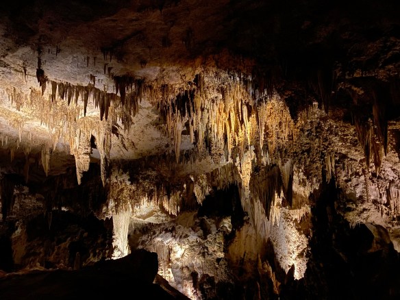
MILE MARKER: Did you know that Carlsbad Caverns was part of an ancient fossilized reef in a long-gone inland sea?! Instead of fish, coral, and sea sponges, you now have towering stalagmites, stalactites, and weird cave formations made from limestone that was once alive with marine life. You’re literally walking through the skeleton of a prehistoric ocean!!

HIKE IT!: If you decide to venture into the caverns and choose to walk down using the Big Room route instead of taking the elevator, you will have hike approximately 1.25 miles. The walk is relatively flat and will take you approximately 1.5 hours to (average) to walk. There is a shorter route available which is about .6 mile and will take approximately 45 minutes (average) to complete. Only clear water is allowed in the cavern. Also, hiking sticks are not allowed unless medically necessary. If you’re interested in a surface hike, there are trails in and around the area. Check here for back country trail information prior to making your plans as some of these trails have been subject to repair and renovation after a flood in 2022.

Trail Mix #2

Got questions? We might have some answers!! Tune in for a short chat about questions or comments some of you have mentioned either on our Facebook Page, YouTube, or Instagram.

This episode, we’ll be discussing…

  • What’s the difference between walking and hiking?
  • What is your favorite small park?
  • Would we ever consider doing guided hikes?
  • What’s the difference between an NPS Park Store and an affiliate store?
  • Can you take things from National Parks?
  • Who decided gold was the standard of wealth back in the gold rush days?

If you have any other questions or comments, feel free to write them below. If you let us know, we’ll hand out some more trail mix in a future podcast. Thanks for listening!

Hiking Around an Ancient Volcano: Devils Tower National Monument

Photo by S. Resendez

Many people will look at this towering section of striated stone and think to themselves that it looks familiar, even if they’ve never been there. Yes, this is the site made famous in the Steven Spielberg 1977 movie, Close Encounters of the Third Kind. But before it became a focal point of a movie about contact with extraterrestrials, it was famous in its own right. The Devils Tower National Monument, also known as Bear Lodge, was dedicated by President Theodore Roosevelt as America’s first national monument in 1906.

Photo by S. Resendez

There are a multitude of theories surmising how the tower came to be. In reality, all theories agree that the tower did not start out as a tower. In fact, the structure began beneath the earth’s surface and was created from magma that came to be in its current state via erosion. We will probably never know which theory regarding the actual creation is correct due to the fact that the erosion essentially eliminated the evidence to substantiate any theory.

Photo by S. Resendez

Despite questions surrounding its creation, the physical tower is imposing. Devils Tower is 1,267 feet (386 m) tall and sits above the Belle Fourche River. It is the world’s largest example of columnar jointing. It is considered a sacred place for over 20 Native American tribes and ceremonies are still held there. As you walk on the trails, you may come across cloths or small bundles attached to the trees. These are Native American prayer cloths and represent the spiritual connection some tribes have with the Tower. Do not touch, disturb or remove the prayer cloths. Also, it is considered culturally insensitive to photograph these prayer cloths.

Park roads and trails are open 24 hours/day. Visitor Center/Library summer hours are from 9a to 6p. Hours change by season so if you want to see the visitor center, make sure you verify on the website before going. The park usually sees around 500,000 visitors per year; over 80% of whom come between Memorial Day and Labor Day (late May to early September), so plan accordingly.

Parking is very limited. The park often experiences maximum parking capacity for several hours every day throughout the summer (usually between 10a-3p). There is a map and a suggestion to park outside the park and hike into the visitor’s center, if you don’t want to deal with the parking issue.

Accessibility: The Visitor Center is wheelchair accessible and can accommodate wheelchairs up to 35 inches in width. Accessible restrooms are available. While the trail loop is paved, steep grades mean the trail is not recommended for wheelchair users.

Photo by S. Resendez

MILE MARKER: The word for devil/evil spirit is Wakansica. It can be translated as “bad god” or “evil spirit”. The Lakota word for black bear is Wahanksica. It is possible that the name Devils Tower, which is called “Bear Lodge” in Lakota, came about due to a mistranslation of “Wahanksica” for “Wakansica”. It is also possible that Colonel Richard Irving Dodge, a man who publicly advocated for the genocide of Native Americans, ascribed the name Devils Tower to this sacred mountain merely to offend and disrespect indigenous tribes. To find out more about the movement to restore the original Native American name of Devils Tower back to Bear Lodge, click here.

HIKE IT!: There are several hiking trails in and around the Devils Tower. The most popular is the Tower Trail but there are plenty of other hiking trails for hikers of different levels to enjoy. The NPS website for Devils Tower does a great job of breaking down the hiking trails based on how much time you think you plan on spending at the park. Make sure you check it out and plan your hike ahead of time!

Help Out the Two Chicks!!

Two Chicks at Fort Davis

We have a favor to ask of you all…

If you’ve checked out our video podcasts and if you’ve enjoyed the content we’ve been sharing with you, we would REALLY appreciate it if you would go to our YouTube Channel and SUBSCRIBE.

We promise you won’t find a mailbox full of emails you don’t need, you’ll just be helping us on YouTube so we can get our content out and build our audience.

Our YouTube Channel address is https://www.youtube.com/@TwoChicksWithHikingSticks

When you click the link above, it will take you directly to our YouTube Page. From there, it’s as easy as clicking “Subscribe”. That’s it! Super easy and you’ll be helping us out. Thanks in advance for your help!

(Liking our posts here and subscribing to our blog posts also helps us out. We appreciate all of you who are taking the time to read our posts!)

Screenshot

West Texas Gems: Balmorhea and the Chihuahuan Desert Nature Center

There are signs that in around 1849, Mescalero Apache watered their horses at the Mescalero Springs. Later, Mexican farmers dug canals by hand to irrigate their crops, which they later sold to people who lived in Fort Davis. The farmers called these springs the San Solomon Springs. In 1927, the springs were dredged and a canal was built to better utilize the flow of the water. Records show that the springs around Balmorhea have been in use for almost 11,000 years.

San Solomon Springs Motor Courts
Photo by S. Resendez

In 1934, the State Board of Texas acquired approximately 46 acres around the San Solomon Springs. The Civilian Conservation Corp (CCC) arrived at the springs in July 1934 and began work on building what would later become Balmorhea State Park. The CCC created the 1.3 acre pool around the springs. They also built the concession building, the bath houses, and the motel court using native limestone and hand hewn adobe bricks.

Balmorhea Swimming Pool Photo by S. Resendez

The San Solomon Springs is the largest in a series of 6 springs located in the Chihuahuan desert. The Balmorhea State Park Swimming Pool is the world’s largest spring-fed pool and often referred to as the crown jewel of the Texas State Parks System. The springs originally emptied into what is known as a ciénga or desert wetland. Construction of the swimming pool, back in 1934, resulted in the destruction of the natural springs which were rebuilt and fashioned into two man-made ciéngas.

Ciénega Photo by M. Gonzalez

There is an overlook by the RV section of the park for visitors to look for wildlife like deer, javelina, squirrels, turtles, lizards and dragonflies, which also utilize the springs. San Solomon Springs also serves as a stop for resident and migratory birds and is home to several rare and endangered species of snails and fish. San Solomon Springs is the largest spring in the Balmorhea area, and the habitat at Balmorhea State Park is very important for the con­ser­vation of these species.

Balmorhea State Park is located at 9207 TX-17, Toyahvale, TX 79786. Daily entrance fee for adults is $7 and free for children 12 and under. Park hours are from 8a to 7:30p or sunset (whichever comes first) and office hours are from 8a-5p. They often reach capacity and highly recommend reservations for both camping and day use. You can reserve passes online or by calling the customer service center before you visit. Check the park’s Facebook page for updates. Read their FAQ page for more detailed information about park and pool rules. Make sure you plan your visit before going!

Chihuahuan Desert Nature Center Entrance
Photo by S. Resendez

About 41 miles south and just outside of Fort Davis, Texas, sits the Chihuahuan Desert Nature Center. The Chihuahuan Desert Research Institute (CDRI) is a nonprofit organization that was established in 1973 and housed in Alpine, Texas. Its principal founders were science professors at Sul Ross State University, a university that the institute continues to work closely with today. Today, the CDRI is the Chihuahuan Desert Nature Center and is located on 507 acres in the foothills of the Davis Mountains.

Susan intently studying the locations of the mines! Photo by M. Gonzalez

The Nature Center is open year round. If you’re interested in exhibits about geology, history, and culture of the Chihuahuan desert, there is a mining exhibit detailing desert mining and the geological changes that have occurred in the Trans-Pecos of Texas over the last 2 billion years! A bird blind is available for birders, and there’s a cactus museum which houses over 200 species, sub-species, and varieties of cacti and succulents.

If you don’t feel like hiking, there are botanical gardens which encompass a wildscape garden, a self-guided stroll through a Trans Pecos Natives garden, a pollinator garden trail, and a native grasses exhibit.

Check the website for Chihuahuan Desert Nature Center before heading out. The Center is located off of Hwy 118, 4 miles SE of Fort Davis at 43869 St. Hwy. 118, Their hours are Monday-Saturday, 9a-5p.

MILE MARKER: Would you believe that cactus can be found as far north as Canada?! Some species have evolved to withstand cold temperatures and dry conditions. Southern prairies and certain regions by the Great Lakes, provide habitats with enough sun, well-drained soil, and suitable temperatures for cacti to thrive.

HIKE IT!: There are lots of great hiking trails at the Chihuahuan Desert Nature Center. There are 5 trails ranging from .25 mile (scenic loop inside the botanical garden) to a 2.5 mile loop, which is considered a strenuous hike. Remember, you are hiking at an elevation of approximately 5,000 feet! Consider the weather and your own physical abilities. While the trails are mostly earthen, they may be uneven so take your hiking sticks, sunscreen, a good hat to cover your head and face, and plenty of water. After all, you’re desert hiking!

Trail Map for CDNC Photo courtesy of Chihuahuan Desert Nature Center