Hiking Around an Ancient Volcano: Devils Tower National Monument

Photo by S. Resendez

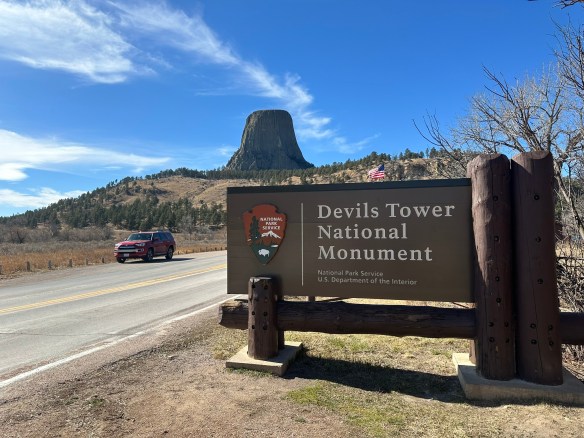
Many people will look at this towering section of striated stone and think to themselves that it looks familiar, even if they’ve never been there. Yes, this is the site made famous in the Steven Spielberg 1977 movie, Close Encounters of the Third Kind. But before it became a focal point of a movie about contact with extraterrestrials, it was famous in its own right. The Devils Tower National Monument, also known as Bear Lodge, was dedicated by President Theodore Roosevelt as America’s first national monument in 1906.

Photo by S. Resendez

There are a multitude of theories surmising how the tower came to be. In reality, all theories agree that the tower did not start out as a tower. In fact, the structure began beneath the earth’s surface and was created from magma that came to be in its current state via erosion. We will probably never know which theory regarding the actual creation is correct due to the fact that the erosion essentially eliminated the evidence to substantiate any theory.

Photo by S. Resendez

Despite questions surrounding its creation, the physical tower is imposing. Devils Tower is 1,267 feet (386 m) tall and sits above the Belle Fourche River. It is the world’s largest example of columnar jointing. It is considered a sacred place for over 20 Native American tribes and ceremonies are still held there. As you walk on the trails, you may come across cloths or small bundles attached to the trees. These are Native American prayer cloths and represent the spiritual connection some tribes have with the Tower. Do not touch, disturb or remove the prayer cloths. Also, it is considered culturally insensitive to photograph these prayer cloths.

Park roads and trails are open 24 hours/day. Visitor Center/Library summer hours are from 9a to 6p. Hours change by season so if you want to see the visitor center, make sure you verify on the website before going. The park usually sees around 500,000 visitors per year; over 80% of whom come between Memorial Day and Labor Day (late May to early September), so plan accordingly.

Parking is very limited. The park often experiences maximum parking capacity for several hours every day throughout the summer (usually between 10a-3p). There is a map and a suggestion to park outside the park and hike into the visitor’s center, if you don’t want to deal with the parking issue.

Accessibility: The Visitor Center is wheelchair accessible and can accommodate wheelchairs up to 35 inches in width. Accessible restrooms are available. While the trail loop is paved, steep grades mean the trail is not recommended for wheelchair users.

Photo by S. Resendez

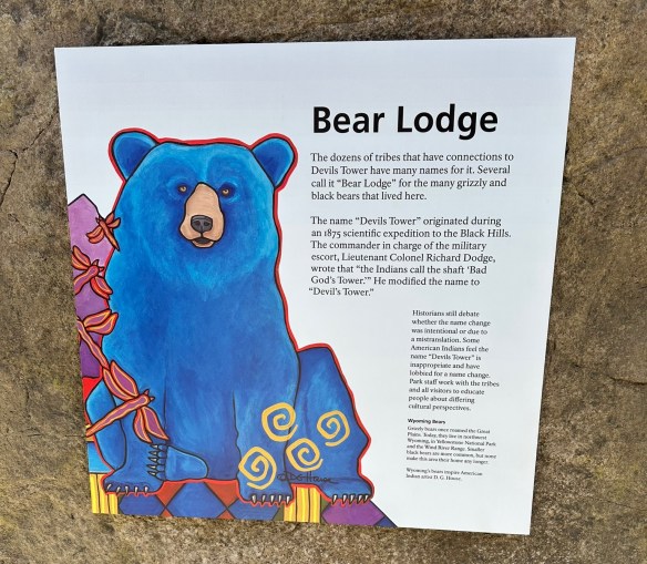
MILE MARKER: The word for devil/evil spirit is Wakansica. It can be translated as “bad god” or “evil spirit”. The Lakota word for black bear is Wahanksica. It is possible that the name Devils Tower, which is called “Bear Lodge” in Lakota, came about due to a mistranslation of “Wahanksica” for “Wakansica”. It is also possible that Colonel Richard Irving Dodge, a man who publicly advocated for the genocide of Native Americans, ascribed the name Devils Tower to this sacred mountain merely to offend and disrespect indigenous tribes. To find out more about the movement to restore the original Native American name of Devils Tower back to Bear Lodge, click here.

HIKE IT!: There are several hiking trails in and around the Devils Tower. The most popular is the Tower Trail but there are plenty of other hiking trails for hikers of different levels to enjoy. The NPS website for Devils Tower does a great job of breaking down the hiking trails based on how much time you think you plan on spending at the park. Make sure you check it out and plan your hike ahead of time!

Help Out the Two Chicks!!

Two Chicks at Fort Davis

We have a favor to ask of you all…

If you’ve checked out our video podcasts and if you’ve enjoyed the content we’ve been sharing with you, we would REALLY appreciate it if you would go to our YouTube Channel and SUBSCRIBE.

We promise you won’t find a mailbox full of emails you don’t need, you’ll just be helping us on YouTube so we can get our content out and build our audience.

Our YouTube Channel address is https://www.youtube.com/@TwoChicksWithHikingSticks

When you click the link above, it will take you directly to our YouTube Page. From there, it’s as easy as clicking “Subscribe”. That’s it! Super easy and you’ll be helping us out. Thanks in advance for your help!

(Liking our posts here and subscribing to our blog posts also helps us out. We appreciate all of you who are taking the time to read our posts!)

Screenshot

West Texas Gems: Balmorhea and the Chihuahuan Desert Nature Center

There are signs that in around 1849, Mescalero Apache watered their horses at the Mescalero Springs. Later, Mexican farmers dug canals by hand to irrigate their crops, which they later sold to people who lived in Fort Davis. The farmers called these springs the San Solomon Springs. In 1927, the springs were dredged and a canal was built to better utilize the flow of the water. Records show that the springs around Balmorhea have been in use for almost 11,000 years.

San Solomon Springs Motor Courts
Photo by S. Resendez

In 1934, the State Board of Texas acquired approximately 46 acres around the San Solomon Springs. The Civilian Conservation Corp (CCC) arrived at the springs in July 1934 and began work on building what would later become Balmorhea State Park. The CCC created the 1.3 acre pool around the springs. They also built the concession building, the bath houses, and the motel court using native limestone and hand hewn adobe bricks.

Balmorhea Swimming Pool Photo by S. Resendez

The San Solomon Springs is the largest in a series of 6 springs located in the Chihuahuan desert. The Balmorhea State Park Swimming Pool is the world’s largest spring-fed pool and often referred to as the crown jewel of the Texas State Parks System. The springs originally emptied into what is known as a ciénga or desert wetland. Construction of the swimming pool, back in 1934, resulted in the destruction of the natural springs which were rebuilt and fashioned into two man-made ciéngas.

Ciénega Photo by M. Gonzalez

There is an overlook by the RV section of the park for visitors to look for wildlife like deer, javelina, squirrels, turtles, lizards and dragonflies, which also utilize the springs. San Solomon Springs also serves as a stop for resident and migratory birds and is home to several rare and endangered species of snails and fish. San Solomon Springs is the largest spring in the Balmorhea area, and the habitat at Balmorhea State Park is very important for the con­ser­vation of these species.

Balmorhea State Park is located at 9207 TX-17, Toyahvale, TX 79786. Daily entrance fee for adults is $7 and free for children 12 and under. Park hours are from 8a to 7:30p or sunset (whichever comes first) and office hours are from 8a-5p. They often reach capacity and highly recommend reservations for both camping and day use. You can reserve passes online or by calling the customer service center before you visit. Check the park’s Facebook page for updates. Read their FAQ page for more detailed information about park and pool rules. Make sure you plan your visit before going!

Chihuahuan Desert Nature Center Entrance
Photo by S. Resendez

About 41 miles south and just outside of Fort Davis, Texas, sits the Chihuahuan Desert Nature Center. The Chihuahuan Desert Research Institute (CDRI) is a nonprofit organization that was established in 1973 and housed in Alpine, Texas. Its principal founders were science professors at Sul Ross State University, a university that the institute continues to work closely with today. Today, the CDRI is the Chihuahuan Desert Nature Center and is located on 507 acres in the foothills of the Davis Mountains.

Susan intently studying the locations of the mines! Photo by M. Gonzalez

The Nature Center is open year round. If you’re interested in exhibits about geology, history, and culture of the Chihuahuan desert, there is a mining exhibit detailing desert mining and the geological changes that have occurred in the Trans-Pecos of Texas over the last 2 billion years! A bird blind is available for birders, and there’s a cactus museum which houses over 200 species, sub-species, and varieties of cacti and succulents.

If you don’t feel like hiking, there are botanical gardens which encompass a wildscape garden, a self-guided stroll through a Trans Pecos Natives garden, a pollinator garden trail, and a native grasses exhibit.

Check the website for Chihuahuan Desert Nature Center before heading out. The Center is located off of Hwy 118, 4 miles SE of Fort Davis at 43869 St. Hwy. 118, Their hours are Monday-Saturday, 9a-5p.

MILE MARKER: Would you believe that cactus can be found as far north as Canada?! Some species have evolved to withstand cold temperatures and dry conditions. Southern prairies and certain regions by the Great Lakes, provide habitats with enough sun, well-drained soil, and suitable temperatures for cacti to thrive.

HIKE IT!: There are lots of great hiking trails at the Chihuahuan Desert Nature Center. There are 5 trails ranging from .25 mile (scenic loop inside the botanical garden) to a 2.5 mile loop, which is considered a strenuous hike. Remember, you are hiking at an elevation of approximately 5,000 feet! Consider the weather and your own physical abilities. While the trails are mostly earthen, they may be uneven so take your hiking sticks, sunscreen, a good hat to cover your head and face, and plenty of water. After all, you’re desert hiking!

Trail Map for CDNC Photo courtesy of Chihuahuan Desert Nature Center