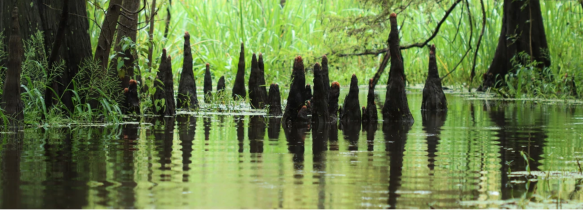
National Park Service, Big Thicket National Preserve, Photo by Scott Sharaga
Big Thicket National Preserve was established in October of 1974 and was the first of the National Preserves in the United States. Big Thicket encompasses an area of approximately 113,000 acres and works its way through several counties and at least 6 waterways.
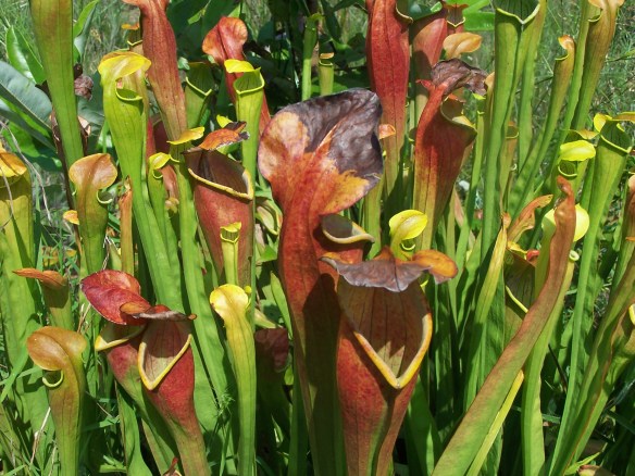
The Big Thicket is located near Beaumont, Texas and is considered part of the Piney Woods of East Texas. With a diverse range of plants and animals, it is often referred to as “America’s Ark” for its mind-blowing biodiversity. The Big Thicket serves as host for over 1,300 plant species, including 4 types of carnivorous plants! There are alligators, bobcats, armadillos, and over 300 bird species. As a matter of fact, Big Thicket is very popular during the bird migratory season. Swamps, pine forests, and sandhills comprise multiple ecosystems in one park. There are rare orchids and pitcher plants thriving in its boggy areas and 40 miles of hiking trails through diverse habitats across 9 diverse ecosystems.

National Park Service, Big Thicket National Preserve, Photo by Scott Sharaga
Here are the nine distinct ecological systems within the Big Thicket:
- Pine Forests–Includes the longleaf pine and loblolly pine. Often maintained by controlled burns to mimic natural wildfires.
- Hardwood Forests–Includes oak, hickory, sweetgum, and beech trees. Great for birdwatching and spotting woodland wildlife.
- Swamps–Saturated lowlands with bald cypress and water tupelo. Many of these support hanging mosses and aquatic plants.
- Baygalls–Waterlogged areas fed by groundwater, often at the base of slopes. Characterized by sweetbay, blackgum, and magnolia trees. This system houses rare amphibians, orchids, and carnivorous plants.
- Sandhills–Dry, sandy ridges with scrub oaks and grasses.
- Savannahs–These are open grassy areas dotted with scattered trees and maintained by fire. This area serves as home to pitcher plants and wildflowers. It also serves as a transitional zone between the forest and prairie.
- Floodplains and Bottom Lands–Found along the Neches River and other waterways.
- Bogs–Acidic wetlands with peaty soils. This area is famous for its carnivorous plants: pitcher plants, sundews, and bladderworts.
- Riparian Corridors–Edges of streams and creeks, vital for aquatic and semi-aquatic species.
As you can see, there is something for every type of hiker in the Big Thicket!
The Big Thicket Visitor Center is open 9:00 am to 5:00 pm, central time, 7 days a week. It is closed on Thanksgiving, December 25, and January 1. The roads, trails, and waterways of the preserve are open 24 hours. To spend a night in the preserve, you’ll need a free backcountry camping permit from the visitor center. Are you a hunter or trapper? Remember, Big Thicket’s hunting season runs from early October to the end of February. Hog trapping season runs from early February until the start of hunting season in October. Permits for hunting and trapping are available at the visitor center.
Big Thicket offers opportunities for camping, hiking, swimming, hunting, trapping, fishing, and paddling! Make sure you check in with the Visitor’s Center for the latest information on the preserve and any updates you may need to know before you head out.

Accessibility: The Visitor Center is wheelchair accessible as are bookstore, exhibits, and theater. The park film is open-captioned and audio described. Assistive Listening Devices (ALDs) are available at the front desk. For people with sensory issues, sensory kits are also available at the front desk. Also, Sundew Trail Inner Loop and the Pitcher Plant Trail are wheelchair accessible, as well as picnic tables and restrooms within the preserve.
MILE MARKER: Big Thicket was the first U.S. national preserve created specifically to protect a biological (not scenic or geological) resource.
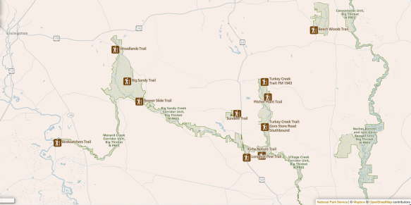
HIKE IT!: Big Thicket National Preserve has over 30 miles of hiking trails. From short loops to long backcountry trails, hiking is one of the best ways to explore the preserve. And if you’re really interested in getting to know Big Thicket, check out our FREE downloadable Big Thicket Ecosystem Scavenger Hunt! checklist. This checklist can help you make your way through all the ecosystems and guide you on what to look for in each area.